
Tropical Storm “Nalgae” (Paeng) strengthening ahead of landfall in northern Philippines
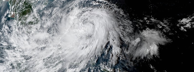
Featured image: Tropical Storm "Nalgae" (Paeng) at 07:50 UTC on October 28, 2022. Credit: JMA/Himawari-8, RAMMB/CIRA, The Watchers
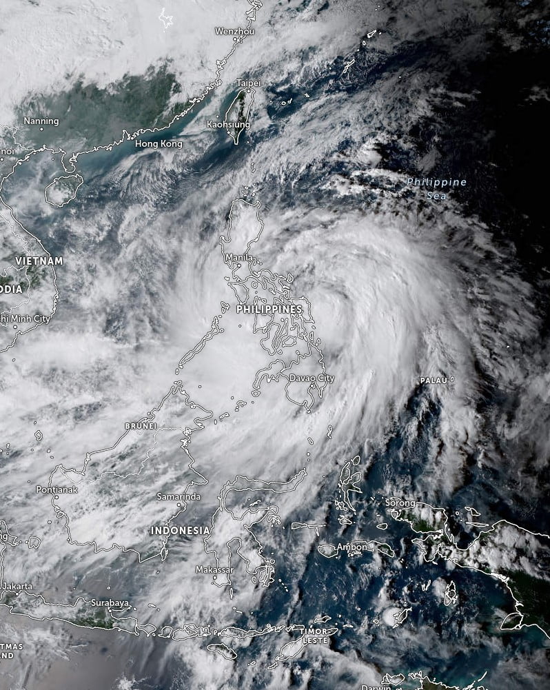
Tropical Storm “Nalgae” — known as Paeng in the Philippines — formed on October 27, 2022, in the Philippine Sea as the 22nd named storm of the 2022 Pacific typhoon season. The storm is already blamed for the deaths of at least 13 people in the Philippines.
The first landfall is expected around 18:00 UTC on October 28. However, heavy rains caused by this system since October 27 caused floods and landslides in which at least 13 people lost their lives.
10 of them were from the flood-hit town of Datu Blah Sinsuat on Mindanao island, said Naguib Sinarimbo — civil defense chief for the regional government.
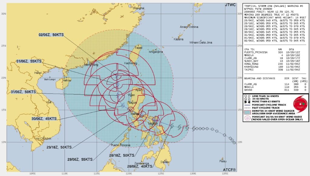
At 06:00 UTC on October 28, the center of Tropical Storm “Nalgae” was located about 660 km (410 miles) ESE of Manila, Philippines.
It had maximum 10- and 1-minute sustained winds of 75 km/h (45 mph), with gusts to 110 km/h (45 mph).
The minimum central barometric pressure was 994 hPa and the system was moving WNW at 26 km/h (16 mph).
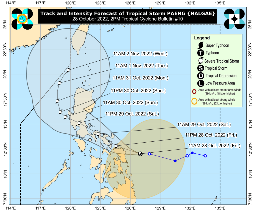
The system is forecast to continue moving W or WNW over the next 12 hours, PAGASA said in its bulletin released at 06:00 UTC today (14:00 LT).
Due to the westward movement of this tropical cyclone, a landfall scenario or close approach to Eastern Samar or Northern Samar this afternoon or tonight (LT) is not ruled out.
Afterwards, Nalgae (Paeng) will move generally WNW and may traverse the Bicol Region tonight through tomorrow morning (LT).
Between tomorrow afternoon and evening (LT), the center of Nalgae may make another landfall over the east coast of Quezon (including Polillo Islands) or Aurora.
The system is forecast to further intensify while moving over the warm waters of the Philippine Sea and may reach a severe tropical storm category within 24 hours.
Hazards affecting land areas
Heavy rainfall
Today through tomorrow early morning (LT): Heavy to intense with at times torrential rains likely over Bicol Region and Eastern Visayas. Moderate to heavy with at times intense rains over Quezon, MIMAROPA, Caraga, Zamboanga Peninsula, BARMM, Northern Mindanao, and the rest of Visayas. Light to moderate with at times heavy rains possible over Metro Manila, Cagayan Valley, Aurora, and the rest of CALABARZON and Mindanao.
Tomorrow morning through Sunday morning, October 30: Heavy to intense with at times torrential rains likely over CALABARZON, Bicol Region, Aurora, Isabela, Nueva Vizcaya, and Quirino. Moderate to heavy with at times intense rains over Metro Manila, mainland Cagayan, Cordillera Administrative Region, Western Visayas, Marinduque, Romblon, Mindoro Provinces, and the rest of Central Luzon. Light to moderate with at times heavy rains possible over Zamboanga Peninsula and the rest of Luzon and Visayas.
Under these conditions, flooding and rain-induced landslides are expected, especially in areas that are highly or very highly susceptible to these hazards as identified in hazard maps and in localities with significant antecedent rainfall.
Heavy rain areas may be updated in the succeeding bulletins should there be significant shifts in the track and intensity forecast, PAGASA said.
Severe winds
Winds may reach gale-force strength during the passage of Nalgae (Paeng) within any of the areas where Tropical Cyclone Wind Signal No. 2 is hoisted. Strong winds may be experienced within any of the areas where Tropical Cyclone Wind Signal (TCWS) No. 1 is hoisted throughout the entire passage.
Per latest track and intensity forecast, the highest wind signal that will likely be hoisted is Wind Signal No. 3 in anticipation of storm-force conditions associated with this system.
The surge of the Northeast Monsoon enhanced will also bring strong winds with gusts reaching gale-force strength over Batanes, Babuyan Islands, Ilocos Provinces, the northern and eastern portions of mainland Cagayan, the eastern portions of Isabela, and the northern portion of Apayao.
Coastal inundation
There is minimal to moderate risk of storm surge of up to 2.0 m in height which may cause flooding in the low-lying and exposed coastal areas of Bicol Region, Quezon including Pollilo Islands, the eastern portion of Aurora, the northern and eastern portions of Northern Samar, and the eastern portion of Eastern Samar. For more information refer to Storm Surge Watch #2 issued at 2:00 PM today.
Hazards affecting coastal areas
Under the influence of the surge of the Northeast Monsoon, a marine gale warning is in effect over the seaboards of Northern Luzon and the eastern seaboards of Central Luzon, Southern Luzon, Visayas, and Mindanao.
Tropical Cyclone Wind Signal no. 2
Affected areas:
- Luzon
- Catanduanes, Albay, Sorsogon, Masbate including Ticao and Burias Islands, Camarines Sur, Camarines Norte, Marinduque, the northern portion of Romblon (Calatrava, San Andres, San Agustin, Romblon, Corcuera, Banton, Concepcion, Cajidiocan, San Fernando, Magdiwang), Quezon including Pollilo Islands, the eastern portion of Batangas (Lobo, Taysan, Rosario, Padre Garcia, San Juan, Lipa City, Santo Tomas), and the sounteastern portion of Laguna (Alaminos, San Pablo City, Rizal, Nagcarlan, Majayjay, Luisiana, Cavinti, Paete, Kalayaan, Santa Maria, Mabitac, Pakil, Famy, Siniloan, Pangil, Lumban, Liliw)
- Visayas
- Northern Samar, Eastern Samar, Samar, Biliran, and the northern portion of Leyte (San Isidro, Calubian, Tabango, Leyte, Capoocan, Carigara, Barugo, San Miguel, Babatngon, Tacloban City, Alangalang, Santa Fe, Palo, Tanauan, Dagami, Pastrana, Jaro, Kananga, Villaba, Tunga, Tabontabon, Tolosa)
- Mindanao
- –
Tropical Cyclone Wind Signal no. 1
Affected areas:
- Luzon
- The rest of Romblon, the rest of Laguna, Rizal, Occidental Mindoro including Lubang Islands, Oriental Mindoro, Calamian Islands, Cuyo Islands, the rest of Batangas, Cavite, Metro Manila, Bataan, Pampanga, Bulacan, Tarlac, Nueva Ecija, Aurora, Zambales, Pangasinan, La Union, Benguet, Nueva Vizcaya, Quirino, the central and southern portions of Isabela (San Agustin, Jones, City of Santiago, Cordon, Echague, Dinapigue, San Mariano, San Guillermo, Angadanan, City of Cauayan, Benito Soliven, Ramon, San Isidro, Alicia, San Mateo, Cabatuan, Luna, Reina Mercedes, Naguilian, Palanan, Aurora, Burgos, San Manuel, Gamu, Ilagan City, Divilacan), Ifugao, the southern portion of Ilocos Sur (Sugpon, Cervantes, Alilem, Suyo, Tagudin, Santa Cruz, Sigay), and the southwestern portion of Mountain Province (Bauko, Sabangan, Tadian)
- Visayas
- Southern Leyte, Cebu including Bantayan and Camotes Islands, Bohol, Negros Occidental, Negros Oriental, Guimaras, Aklan, Antique, Capiz, Iloilo, Siquijor, and the rest of Leyte
- Mindanao
- Dinagat Islands, Surigao del Norte including Siargao and Bucas Grande Islands, the northern portion of Surigao del Sur (Carrascal, Cantilan, Madrid, Carmen, Lanuza, Cortes, City of Tandag, Bayabas, Cagwait, San Miguel, Tago, Marihatag), Agusan del Norte, the northeastern portion of Agusan del Sur (Sibagat), Camiguin, and the eastern portion of Misamis Oriental (Gingoog City, Magsaysay, Medina, Talisayan, Balingoan, Kinoguitan)
Considering these developments, the public and disaster risk reduction and management offices concerned are advised to take all necessary measures to protect life and property. Persons living in areas identified to be highly or very highly susceptible to these hazards are advised to follow evacuation and other instructions from local officials. For heavy rainfall warnings, thunderstorm/rainfall advisories, and other severe weather information specific to your area, please monitor products issued by your local PAGASA Regional Services Division.
References:
1 Tropical Storm “Paeng” bulletin issued by PAGASA at 06:00 UTC (14:00 LT) on October 28, 2022
I'm a dedicated researcher, journalist, and editor at The Watchers. With over 20 years of experience in the media industry, I specialize in hard science news, focusing on extreme weather, seismic and volcanic activity, space weather, and astronomy, including near-Earth objects and planetary defense strategies. You can reach me at teo /at/ watchers.news.
Commenting rules and guidelines
We value the thoughts and opinions of our readers and welcome healthy discussions on our website. In order to maintain a respectful and positive community, we ask that all commenters follow these rules.