
Alert Level for Cotopaxi volcano raised to Yellow, Ecuador
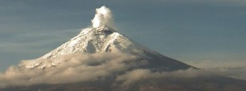
Featured image: Cotopaxi volcano on October 25, 2022. Credit: IGEPN
Minor eruptive activity is taking place at Cotopaxi — one of the world’s most dangerous volcanoes — since October 21, 2022, prompting IGEPN to raise the Alert Level to Yellow (2 of 4).
- After an increase in seismicity since mid-April 2015, Cotopaxi finally erupted on August 14, 2015, for the first time since 1940. Volcanic ash reached an estimated altitude of 15.2 km (50 000 feet) a.s.l. by the end of the UTC day. Highways, homes and cars near the volcano were coated in ash as a result
- The last significant eruption of Cotopaxi took place in 1904
- Cotopaxi is an active stratovolcano in the Andes Mountains, located about 50 km (31 miles) south of the capital Quito, Ecuador
- This is one of the world’s highest volcanoes, reaching a height of 5 897 m (19 347 feet)
- It is considered one of the world’s most dangerous volcanoes due to a glacial cover that makes it prone to fast-moving volcanic rock and mud flows, or lahars, and its proximity to a heavily populated area
A low-amplitude tremor signal recorded by the seismic network on October 21 and 22 was associated with gas-and-ash emissions, IGEPN reports.1
The emissions were not visible due to darkness and weather conditions, but minor ashfall and sulfur odor were reported by mountaineers in the Refugio José Rivas, 2 km (1.2 miles) N of the summit crater. The mountaineers were evacuated.
The Washington VAAC reported that from 21:50 – 22:00 UTC on October 21 ash plumes rose to 7.6 – 8.5 km (25 000 – 28 000 feet) a.s.l. and drifted NE based on information from IG and the Guayaquil MWO, satellite images, and webcam views. The ash had dissipated by 04:10 UTC on October 22.
A second ash plume was identified in webcam and satellite images rising to 7 km (23 000 feet) a.s.l. and drifting W at 07:00 UTC on October 22. Ash was no longer visible by 12:50 UTC.
IG noted that following the end of the tremor signal seismicity declined and plumes of gas-and-steam rose as high as 1 km (3 280 feet) above the summit and drifted W.
Based on the reports from IG the Servicio Nacional de Gestión de Riesgos y Emergencias (SNGRE) raised the Alert Level to Yellow (the second lowest level on a four-color scale) on October 22.
Weather conditions at the volcano improved on October 23 and a layer of dark gray ash on the volcano, deposited the previous two days, became visible.
Based on seismic data and media reports, small secondary lahars generated from the melted glacier beneath the ash deposit traveled short distances down the flanks.
Weather clouds frequently prevented views of the volcano on October 24 and 25, though steam emissions rising 200 m (650 feet) above the summit and drifting W were visible during a break in the cloud cover the morning of October 25.
On Monday, October 24, technicians from the Geophysical Institute inspected the drainages located on the north and northeast flanks of the volcano and found no evidence of secondary lahars that have descended to the lower area of the volcano through these ravines.2
“We assume that the tracks were higher than these flanks. It is probable that these flows originated from a limited melting of the glacier surface, due to the presence of a light layer of black ash and the rains present in the area.”
From October 23 to 26, the seismicity has remained at moderate levels and progressively decreased from 187 to 78 earthquakes per day.
The gases emitted from the crater are at moderate levels and there are no signs of deformation on the flanks of the building. It should be emphasized that the cloudiness in the area of the volcano has been permanent, except for brief moments in the mornings.
On the morning of October 26, a faint white column of gases and water vapor was observed in the Sincholagua chamber (to the NNE of the volcano), rising to 200 m (650 feet) a.s.l.
Geological summary
Symmetrical, glacier-clad Cotopaxi stratovolcano is Ecuador’s most well-known volcano and one of its most active. The steep-sided cone is capped by nested summit craters, the largest of which is about 550 x 800 m (1 800 x 2 600 feet) in diameter.
Deep valleys scoured by lahars radiate from the summit of the andesitic volcano, and large andesitic lava flows extend as far as the base of Cotopaxi.
The modern conical volcano has been constructed since a major edifice collapse sometime prior to about 5 000 years ago.
Pyroclastic flows (often confused in historical accounts with lava flows) have accompanied many explosive eruptions of Cotopaxi, and lahars have frequently devastated adjacent valleys.
The most violent historical eruptions took place in 1744, 1768, and 1877. Pyroclastic flows descended all sides of the volcano in 1877, and lahars traveled more than 100 km (62 miles) into the Pacific Ocean and western Amazon basin. The last significant eruption of Cotopaxi took place in 1904.3
References:
1 Global Volcanism Program, 2022. Report on Cotopaxi (Ecuador). In: Sennert, S K (ed.), Weekly Volcanic Activity Report, 19 October-25 October 2022. Smithsonian Institution and US Geological Survey.
2 UPDATE OF THE STATE OF THE COTOPAXI VOLCANO IN THE LAST 72 HOURS – IGEPN – October 26, 2022
3 Cotopaxi – Geological summary – GVP
I'm a dedicated researcher, journalist, and editor at The Watchers. With over 20 years of experience in the media industry, I specialize in hard science news, focusing on extreme weather, seismic and volcanic activity, space weather, and astronomy, including near-Earth objects and planetary defense strategies. You can reach me at teo /at/ watchers.news.
Commenting rules and guidelines
We value the thoughts and opinions of our readers and welcome healthy discussions on our website. In order to maintain a respectful and positive community, we ask that all commenters follow these rules.