
More than 330 000 customers without power as major winter storm hits California
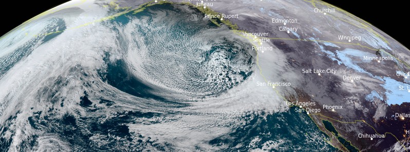
Featured image: Image credit: NOAA/GOES-West, RAMMB/CIRA, TW. Acquired at 00:00 UTC on January 27, 2021
A strong frontal system — Category 3 atmospheric river — impacting California and parts of Nevada through Thursday, January 28, 2021, will bring gusty winds, very heavy rain, and mountain snow, in some parts extreme. Whiteout/blizzard conditions and heavy snow in the Sierra Nevada may cause road closures and travel delays.
- Extreme avalanche danger is expected across Central Sierra Nevada Mountains from Wednesday, January 27 through Friday, January 29.
- Additionally, flash flooding and debris flows are possible across parts of central and southern California.
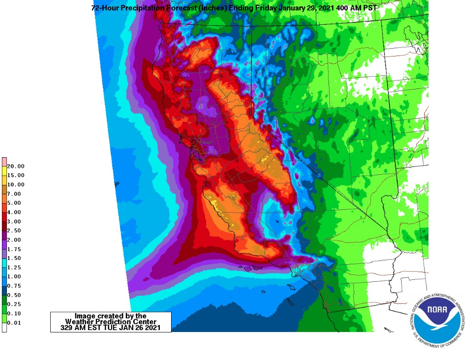
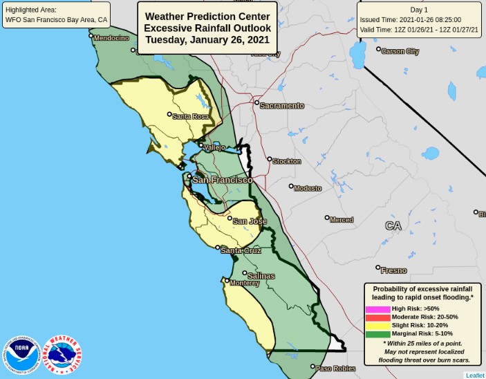
- Over the next three days, as much as 250 – 380 mm (10 to 15 inches) of rain could fall along the central California coast roughly between Monterey and Santa Barbara. This amount of rain in a 72-hour period is very rare for this region, with an annual exceedance probability of only 2%.
- Another significant storm is expected to reach the region early next week! Be ready.
Excessive heavy lower elevation rain is expected to bring dangerous flash flood risk to coastal California into Wednesday, January 27, NWS warns. Meanwhile, extreme snowfall amounts are expected across the Sierra Nevada through Thursday.
As a result of strong winds, more than 330 000 customers in California are without power, as of 09:00 UTC on January 27, and the number keeps rising.
Several major highways were already closed on Tuesday and evacuation orders triggered in San Mateo County in anticipation of heavy rain.
Authorities warned that the 34 800 ha (86 000 acres) of land burned around the Santa Cruz Mountains in the fall of 2020 by the massive CZU Lightning Complex fire is especially vulnerable.
Burn scars left by the Dolan fire, which destroyed over 48 560 ha (120 000 acres) nearby, are also vulnerable.
The soil is now weak without vegetation to hold it in place and at heightened risk for debris flows and mudslides, the LA Times reports.
GOES-WEST IR imagery this evening is capturing the atmospheric river plume rapidly moving into far NW California (eg. Point Mendocino). Overcast conditions across our region will rapidly evolve into heavy rain bands & strong winds this evening. Be weather-aware tonight! #CaWx pic.twitter.com/Vqb8oOlup7
— NWS Bay Area (@NWSBayArea) January 26, 2021
Blizzard Warning for the Sierra 10 PM tonight thru Friday. Strong winds will produce zero visibility & whiteout conditions with high drifting snow. This will be a dangerous & life-threatening situation. Do not attempt to travel.
Winter Storm Info – https://t.co/CRkNyVZRtH pic.twitter.com/F9Xy8omvTo
— NWS Reno (@NWSReno) January 26, 2021
"This is a blockbuster winter storm event for us," said Mark Deutschendorf, a meteorologist at the National Weather Service in Reno, Nevada.
"Travel is not recommended from late Tuesday night to Friday across the Sierra and Lake Tahoe area, including western Nevada. If you do venture outdoors, be prepared to spend time an extended period of time in your car."
The Sierra Avalanche Center in Truckee has issued a BACKCOUNTRY AVALANCHE WARNING for the Greater Lake Tahoe area a couple of hours ago. Extreme avalanche danger is expected for Wednesday, Thursday, and into Friday morning in the mountains.
The Eastern Sierra Avalanche Center has issued a BACKCOUNTRY AVALANCHE WARNING for the eastern slopes of the Sierra Nevada between Virginia Lakes and Bishop Creek. Widespread high avalanche danger is expected through Friday.
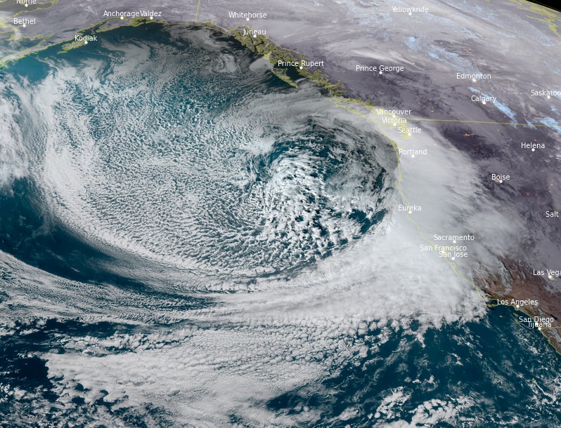
Image credit: NOAA/GOES-West, RAMMB/CIRA, TW. Acquired at 00:00 UTC on January 27, 2021
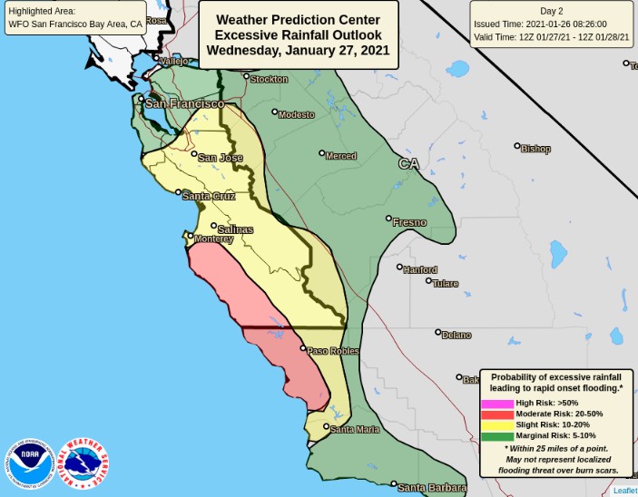
Moderate to heavy rainfall will spread across central and southern California as a robust Pacific front moves inland, NWS meteorologists Campbell and Snell noted early Wednesday morning (EST).
Deep moisture will be directed onshore and will help produce several inches of rain along the coast and lower elevations. Flash flooding and debris flow near recent burn scars may occur.
WPC has highlighted part of this region as having a Moderate Risk for excessive rainfall.
Mountain snow will likely be heavy at times across the Sierra Nevada. Several feet of snow (as much as 3 m / 10 feet) will add up through Thursday night, with road closures and travel delays very likely.
Numerous locations have Winter Storm Warnings and Winter Weather Advisories in effect.
Blizzard Warnings are also in effect for part of the Sierra Nevada. A Flash Flood Watch has been posted as well.
Over the next three days, as much as 250 – 380 mm (10 to 15 inches) of rain could fall along the central California coast roughly between Monterey and Santa Barbara.
This amount of rain in a 72-hour period is very rare for this region, with an annual exceedance probability of only 2%.
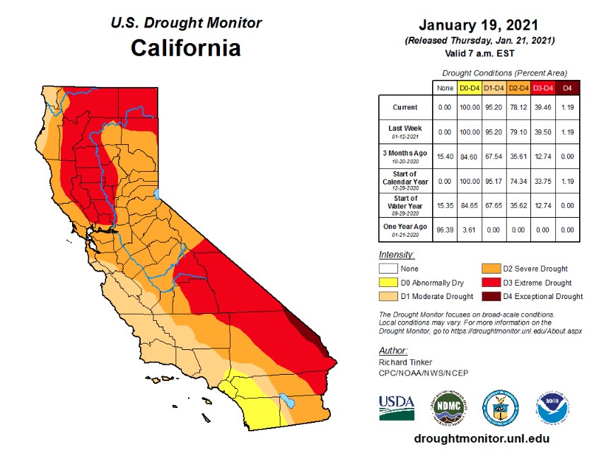
While extremely dangerous, this weather event is expected to provide much-needed relief as the current statewide snowpack in California is just 40% of the average to date.
Severe drought conditions cover nearly 80% of the state, which relies on winter snowpack for water supply.
I'm a dedicated researcher, journalist, and editor at The Watchers. With over 20 years of experience in the media industry, I specialize in hard science news, focusing on extreme weather, seismic and volcanic activity, space weather, and astronomy, including near-Earth objects and planetary defense strategies. You can reach me at teo /at/ watchers.news.
Hi Teo Blašković,
Thanks for your great info! It’s tough to find such comprehensive news about the odd weather now, that we’re in the End of the Earth Age.
May God(dess) bless you & your loved ones and the entire The Watchers news family with good health, lovingkindness, plenty of tasty food&drink in the upcoming test times, joy in your hearts, peace-of-mind&spirit…
Take good care and Cheers,
Joyce
p.s. I posted some important info about the Covid1984 vaccines to Linkedin. When you have a moment, please take a look. Thank you!
https://www.linkedin.com/in/joyce789/
https://www.linkedin.com/feed/update/urn:li:activity:6755825323889303552/
Thank you, Joyce <3