
Tropical Cyclone “Imogen” brings floods and disruptions to Queensland, Australia
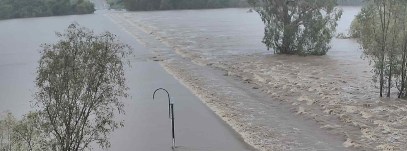
Image credit: Department of Transport and Main Roads, Queensland
Tropical Cyclone "Imogen" brought heavy rains, flooding, and disruptions to Queensland, Australia, after making landfall over Karumba around 13:00 UTC (23:00 LT) on Sunday night, January 3, 2021. It generated 105 km/h (65 mph) winds, dumped more than 200 mm (7.8 inches) of rain, and left 1 400 residents without power.
Imogen crossed the coast near Karumba overnight into Monday, January 4, with winds of 105 km/h (65 mph) and rainfall of 240 mm (9 inches) recorded at Normanton airport.
Karumba resident Verena Olesch said it felt "almost like an earthquake" when the cyclone made landfall. "Everybody was really well prepared, we had a cyclone clean up just before Christmas."
"The rain has stopped for now, and there are light winds. The clean up has already begun and should only be superficial damage."
Olesch added that much of the impact was limited to fallen trees and water damage, but it was "nothing we can’t deal with."
More than 1 000 customers in Normanton and Karumba were left without power in the wake of the storm, as well as 180 on Mornington Island.
Ergon Energy crews were forced to wait for the storm to subside early Monday morning before conducting aerial patrols to identify faults after flooding hampered access to the network.
My brother-in-law filmed this earlier today near his home in Townsville, Queensland. Shortly afterwards the bridge in the video was totally submerged. Welcome to the wet season with added #cycloneimogen. #rain #fnq #weather #Townsville pic.twitter.com/Tcm93ZWafx
— Simon Atkinson (@atko1978) January 5, 2021
North Queensland is on high alert as Cyclone Imogen makes landfall, tearing buildings apart and dumping floodwaters.
As @ebonycavallaro reports, the deluge isn't over yet. #9News pic.twitter.com/Hs98FgyDaO
— 9News Queensland (@9NewsQueensland) January 4, 2021
North Queensland is bracing for the worst with hundreds of millimetres expected to fall in already saturated towns.
Creeks and rivers are bursting their banks as ex-tropical cyclone Imogen continues to carve a path down the coast. @lcalcutt @maya_fellows9 #9News pic.twitter.com/xAziWNRWDe
— 9News Queensland (@9NewsQueensland) January 5, 2021
On Tuesday afternoon (LT), January 5, Imogen was a tropical low located about 120 km (75 miles) east of Georgetown.
A coastal trough extends from Imogen into the Coral Sea, triggering widespread rain, heavy showers, and thunderstorms for the northeast.
Periods of localized intense rainfall are likely along the coast and ranges, which could lead to life-threatening flash flooding. Damaging wind gusts are possible with thunderstorms, from Ingham to Ayr.
The Bureau of Meteorology has issued a marine wind warning, as well as minor, moderate, and major flood warnings for much of Queensland.
Commenting rules and guidelines
We value the thoughts and opinions of our readers and welcome healthy discussions on our website. In order to maintain a respectful and positive community, we ask that all commenters follow these rules.