
Major storm hits U.S. East Coast, leaving more than 230 000 customers without power
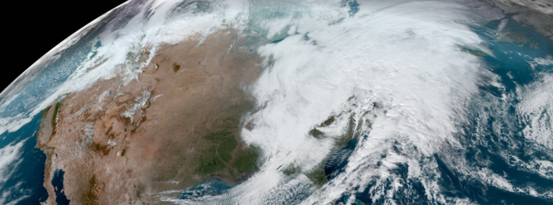
Image credit: NOAA/GOES-16, RAMMB/CIRA, Acquired 18:00 UTC on November 30.
A powerful storm swept through the U.S. East Coast on Monday, November 30, 2020, leaving more than 230 000 customers without power in the region. The storm system brought damaging winds and heavy rains, downing multiple trees and power lines and producing several tornadoes.
Most of the affected customers affected were in Maine, where more than 100 000 lost power, followed by Massachusetts with 47 000 affected customers, Rhode Island with 32 000, Connecticut with 28 000, and New York 23 000. The Storm Prediction Center received around 60 reports of wind damage to trees, power poles, and wires.
In Maine, wind gusts close to 96 km/h (60 mph) downed multiple trees in Durham, Lisbon, Woolwich, and Bar Harbor, among other places. As of Tuesday, December 1, about 102 000 people remain without power in the state, according to poweroutage.us.
The National Weather Service (NWS) issued a high-wind warning for southern Maine effective until Tuesday.
"People should avoid being outside in forested areas and around trees and branches. If possible, remain in the lower levels of your home during the windstorm, and avoid windows. Use caution if you must drive," the NWS said.
In Massachusetts, multiple crashes occurred due to wet and slippery roads, with one which resulted in a punctured fuel tank and spill. No serious injuries were reported, according to the State Police.
As powerful winds continued, authorities advised people to secure any loose outdoor items and prepare emergency lights in case of prolonged outages.
Just got a confirmed 81mph from Blue Hill. Power outages escalating. @boston25 pic.twitter.com/UUCUikEK4T
— Jason Brewer (@JBrewerBoston25) November 30, 2020
It's getting really nasty out there, especially with those strong gusts of wind. Make sure to stay with WCVB and StormTeam 5 for the latest on this impact weather. #MAwx #stormcoverage #Boston #Massachusetts https://t.co/MmYmo3NIpV pic.twitter.com/kHHv37jzka
— WCVB-TV Boston (@WCVB) November 30, 2020
Tree down on Bennington Street in East Boston. @NBC10Boston pic.twitter.com/caDOeY7WqN
— Abbey Niezgoda NBC10 Boston (@AbbeyNBCBoston) November 30, 2020
The system also produced a tornado 22 km (14 miles) west of Dover, Delaware, the NWS confirmed, and possibly at least one twister in Montgomery County. Meanwhile, coastal flooding was reported in the Bower area.
The powerful storm was moving southwest to northeast across the Tennessee Valley to the west of the Philadelphia region and it "pulled up a lot of mild air really quickly," said NWS Mount Holly lead meteorologist, Dean Iovino.
Around 5 500 customers lost power in the area, mostly in the Chester and Montgomery counties.
As of Tuesday, the NWS warned of occasionally heavy rain and possibly some thunderstorms ahead of the cold front, which will likely impact Maine.
"A large and energetic low-pressure system that brought widespread inclement weather across the eastern U.S. yesterday will be slow to depart from the northeastern U.S.," it wrote.
"In addition, gusty southerly winds will be especially strong along the New England coast. Meanwhile, the large circulation of the storm will continue to draw colder air across the Great Lakes and dump snow on the downwind side of the lakes."
"Moderate to heavy snow will be most likely today near the shore of Lake Erie. Some lake-effect snow is also expected near the shore of Lake Michigan today and Lake Ontario on Wednesday (December 2)."
The snow is forecast to dissipate later on Wednesday as the large low-pressure system weakens and moves further into Canada, NWS added.
"Light snow will move farther east across northern New England Wednesday night into Thursday morning (December 3)."
there might have been just as many outages in the lee of the lakes as as out east..i was out twice; they said half the county was down…..some spots got over 20 inches of heavy wet snow after a heavy rain, & hence the branches & wires were covered with 2 inches of ice…i could hear the trees in the woods snapping as i was trying to dig out…