
Tropical Storm “Arthur” forms off the coast of Florida as the first named storm of the 2020 Atlantic hurricane season
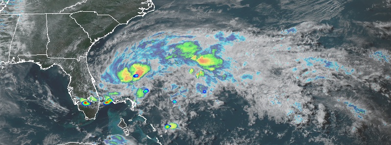
Featured image: Tropical Depression "Arthur" at 21:30 UTC on May 16, 2020 (VIS, CTP and lightning). Credit: NOAA/GOES-East, RAMMB/CIRA
A depression east of Florida has strengthened into Tropical Storm "Arthur" at 03:00 UTC on May 17, 2020, as the first named storm of the 2020 Atlantic hurricane season. The season officially starts on June 1 and ends on November 30, dates that conventionally delimit the period of each year when most tropical cyclones form in the Atlantic basin.
This is the sixth year in a row that the Atlantic Ocean has had at least 1 named storm prior to the official start of the hurricane season.
A Tropical Storm Watch remains in effect for portions of the North Carolina coast — Surf City to Duck, and Pamlico and Albemarle Sounds.
The system has been affecting parts of Florida with heavy rains and thunderstorms even before it fully developed. A number of flash flood warnings were issued along its southeastern coast, while street flooding was reported across the Miami metro area.
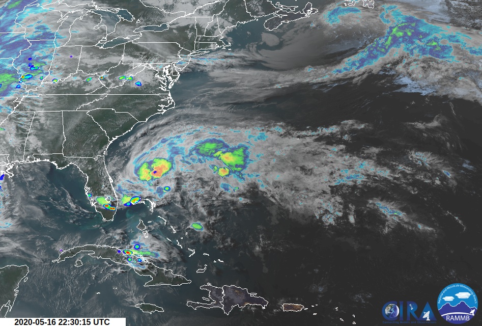
Image credit: NOAA/GOES-East, RAMMB/CIRA. Acquired at 22:30 UTC on May 16, 2020
According to AccuWeather, Thursday, May 14 was the second wettest May day on record for the city of Marathon in the Florida Keys with 146.3 mm (5.76 inches) — the record still holds May 27 of 1959 when the city recorded 167.6 mm (6.60 inches) of rain.
From May 14 to 15, the city recorded 163.8 mm (6.45 inches), up from the average May rainfall of 85 mm (3.35 inches).
GULP.
Just an incredible lightning display at 8:34 pm in Ft. Lauderdale. @Local10Weather @NWSMiami #flwx
And a really good night to stay away from the beach, eh? pic.twitter.com/xyE100kXtM
— Bill Roth (@BillRoth_) May 17, 2020
Incredible #lighting display on #FtLauderdale #Beach #tonight on https://t.co/dK2scSeD09 @NWSMiami pic.twitter.com/qLfFJfMqM4
— PTZtv (@PTZtv) May 17, 2020
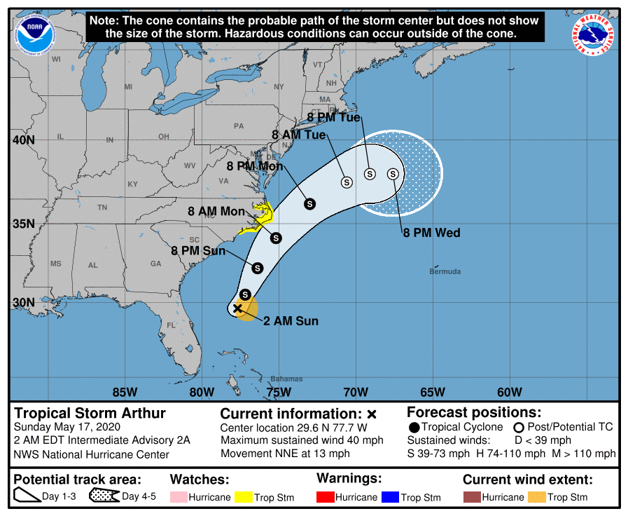
At 06:00 UTC on May 17, the center of Tropical Storm "Arthur" was located about 655 km (405 miles) SSW of Cape Hatteras, North Carolina. The system had maximum sustained winds of 65 km/h (40 mph) and minimum central pressure of 1 006 hPa. The storm is moving NNE at 20 km/h (13 mph).
According to the NHC forecast, this general motion is expected to continue today, followed by a faster NE motion on Monday.
Arthur is expected to remain well offshore the east coast of Florida, Georiga and South Carolina today, and then move near or east of the coast of North Carolina on Monday, May 18.
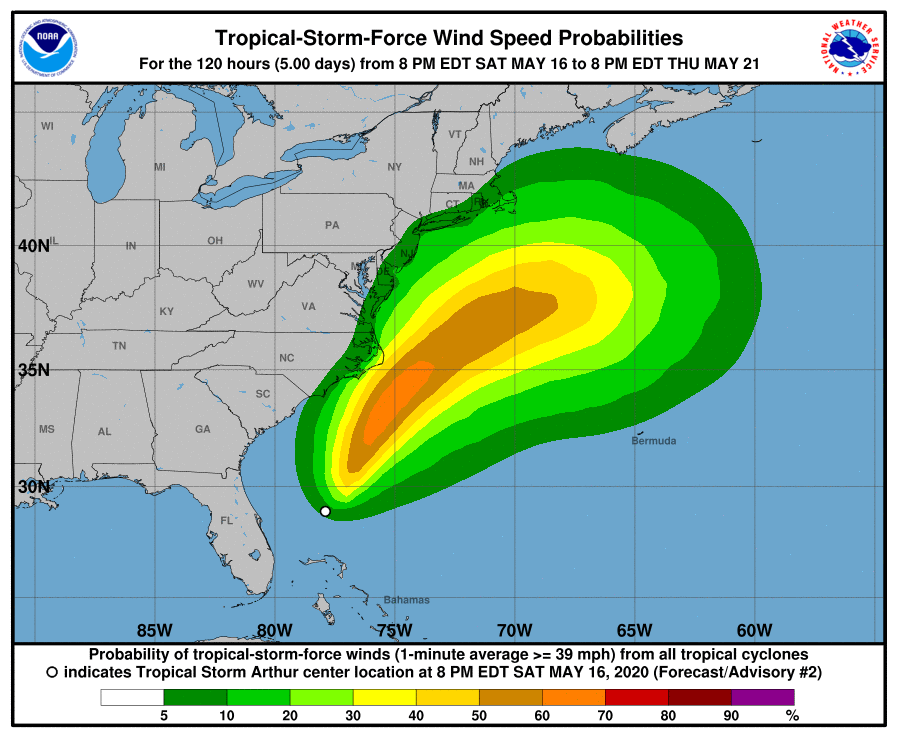
Tropical-storm-force winds extend outward up to 130 km (80 miles) from the center.
Tropical storm conditions are possible within the watch area on Monday.
Arthur is expected to produce additional rain accumulations of 25 – 50 mm (1 to 2 inches) over the central and northwest Bahamas, through this morning.
Arthur is also expected to produce total rain accumulations of 25 – 50 mm over coastal North Carolina tonight and Monday.
Swells generated by Arthur are affecting portions of the east coast of central and northern Florida. These swells are expected to spread northward during the next few days, and could cause life-threatening surf and rip current conditions across much of the U.S. southeast and mid-Atlantic coasts.
I'm a dedicated researcher, journalist, and editor at The Watchers. With over 20 years of experience in the media industry, I specialize in hard science news, focusing on extreme weather, seismic and volcanic activity, space weather, and astronomy, including near-Earth objects and planetary defense strategies. You can reach me at teo /at/ watchers.news.
Commenting rules and guidelines
We value the thoughts and opinions of our readers and welcome healthy discussions on our website. In order to maintain a respectful and positive community, we ask that all commenters follow these rules.