
Winter-like conditions, showers, and thunderstorms expected across the Midwest and the Eastern U.S.
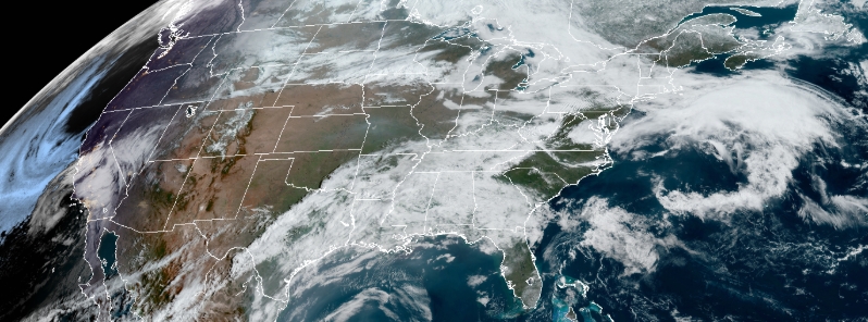
Image credit: NOAA/GOES-West, RAMMB/CIRA. Acquired April 8, 2020, at 14:10 UTC.
Winter-like conditions, showers, and thunderstorms are expected to sweep across the Midwest and the Eastern U.S. as a pair of frontal systems traverse the country's eastern half, according to the National Weather Service's (NWS) forecast on April 8, 2020.
As the bout of severe weather ends in the eastern Ohio Valley on Wednesday morning, April 8 another frontal wave will pose risks farther south into central Mississippi Valley and Tennessee Valley, before a strong cold front arrives from the west in the evening.
"The cold blast will surely bring the perception that winter has returned," said AccuWeather meteorologist Courtney Travis.
By Thursday, April 9, the strong front is predicted to rip through the Eastern U.S., with thunderstorms likely across the states in the Mid-Atlantic region in the morning. There is also a chance for showers and thunderstorms in the western Gulf Coast in the evening.
Rain & snow showers will continue through Thursday. There is an increased risk of snow/rain on Wed-Thurs, but this will be focused for areas south of US 50 in NV and the Eastern Sierra. Are you looking forward to a warm up for late week? More https://t.co/IG7KDUIHQc pic.twitter.com/TZRiI7a2Nu
— NWS Reno (@NWSReno) April 7, 2020
As the strong cold front moves off the East Coast rapidly, a low-pressure system is expected to quickly strengthen near the coast of New England. As a response, winds will pick up across New England, with accumulating snow possible across the northern part of the region.
Winter storm watchers are in force for northern Maine as snow up to 0.3 m (1 foot) is likely. Dangerous travel and whiteout conditions are possible when gusty winds accompany the heavy snow.
"In addition, some lake-effect snow will likely develop on Thursday downwind from the lower Great Lakes on the backside of the low-pressure system," NWS stated.
There will be a dramatic change in the weather across the eastern US this week as a "bomb cyclone" ushers chilly winds, and even some snow, across the region: https://t.co/dzJ1dWzuMg pic.twitter.com/RXnBspF5Hk
— AccuWeather (@breakingweather) April 7, 2020
By the end of the week, areas from the Upper Midwest to the central Appalachians are likely to see the most extreme drop in temperatures.
"A frost or freeze is possible both Friday and Saturday morning over the Shenandoah Valley and perhaps in other locations where blossoms have emerged early due to recent warmth. These blossoms could be damaged," AccuWeather warned.
Commenting rules and guidelines
We value the thoughts and opinions of our readers and welcome healthy discussions on our website. In order to maintain a respectful and positive community, we ask that all commenters follow these rules.