
Severe damage, disrupted communications as Category 5 Severe Tropical Cyclone “Harold” hits Vanuatu
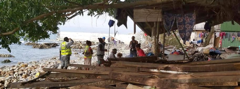
Image credit: IFRC Asia Pacific
Category 5 Severe Tropical Cyclone "Harold" continues to move southeast over the Coral Sea after making landfall over Vanuatu's Espiritu Santo Island at around 00:00 UTC (11:00 LT) and Pentecost at around 07:10 UTC on April 6, 2020, with maximum sustained winds up to 215 km/h (134 mph).
- Severe damage, disrupted communications, and flooding in low-lying areas was reported across Sanma, Malampa, and Penama provinces.
- The Vanuatu Meteorology and Geohazards Department (VMGD) warned that powerful winds will continue to pound the provinces of Sanma, Penama, Malampa, and Shefa.
Residents of the Sanma, Malampa, Torba, and Penama said Monday their provinces were devastated, with communication lines down in the worst-affected areas.
"There is lots of damage in Sanma, they lost lots of buildings," said Vanuatu Red Cross CEO Jacqueline de Gaillande.
"We don't know if we can provide any supports to the island because we are not allowed to travel inter-island and we are waiting for the government to make that decision," she continued. No injuries have been reported at the time of press.
"Red Cross volunteers are supporting their communities by helping people evacuate, undertaking assessments, and sharing life-saving info," the International Federation of Red Cross (IFRC) Asia Pacific also stated.
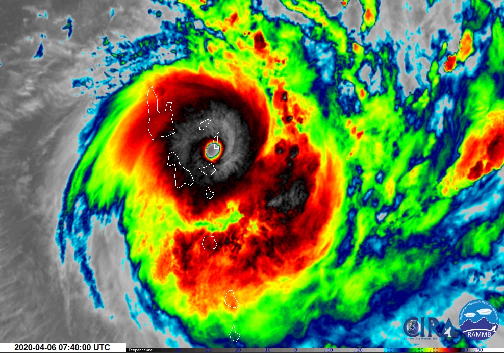
Tropical cyclone "Harold" at 07:40 UTC on April 6, 2020. Credit: JMA/Himawari-8, RAMMB/CIRA
As of 09:00 UTC (20:00 LT), Harold was located about 35 km (22 miles) NE of Ambrym and 80 km (50 miles) N of Epi. The storm was moving in an easterly-southeasterly direction at 19 km/h (12 mph) over the past 3 hours.
Happening now Tropical cyclone Harold is hitting Northern Vanuatu hard.
Red Cross teams are working around the clock supporting their communities by helping people evacuate, undertaking assessments and sharing life-saving info.
@vanuaturedcross #TCHarold pic.twitter.com/t1vsIsbkue
— IFRC Intl. Federation #RedCross #RedCrescent (@ifrc) April 6, 2020
#TCHarold on Santo.
Roof of Maritime office is gone. pic.twitter.com/Md7SWRemS6— YOUmustSTAYatHOME! (@PlainFleur) April 6, 2020
Breaking: #TCHarold has made landfall at 10am this morning on the island of Espiritu Santo in Vanuatu.
Updates coming in from our #PacificClimateWarrior Vanuatu, Paula Leo sharing images from Santo of the impacts of #TCHarold. Prayers go out to our families and friends. pic.twitter.com/ivJlh7gqrO
— 350 Pacific (@350Pacific) April 6, 2020
#Harold Part of the damage caused by the Cyclone #Harold in #Vanuatu pic.twitter.com/h8pOL5hSKx
— Angel Elemiah (@MaximoSPQR) April 6, 2020
#CycloneHarold #Vanuatu #TCHarold #Santo First images coming in from main street of #Luganville on Espiritu Santo island which is experiencing the full force of Harold. pic.twitter.com/ltcVijAyxZ
— Sandra in Vanuatu (@sandravanuatu) April 6, 2020
According to VMGD, damaging gale force winds of 90 km/h (56 mph) gusting to 110 km/h (68 mph) will continue to batter the provinces of Torba and Shefa within the next six to 12 hours.
Destructive storm force winds of 120 km/h (75 mph) with gusts up to 150 km/h (93 mph) are currently affecting the provinces of Sanma, Penama, and Malampa.
Hurricane-force winds of 215 km/h (134 mph) gusting to 235 km/h (146 mph) will continue striking the provinces of Penama and Malampa in the next six to 12 hours.
"Damaging gale force winds, destructive storm force winds and hurricane-force winds with heavy rainfalls and flash flooding over low lying areas and areas close to river banks including coastal flooding is expected over Sanma, Penama, Malampa, and Shefa provinces including Torba," VMGD said.
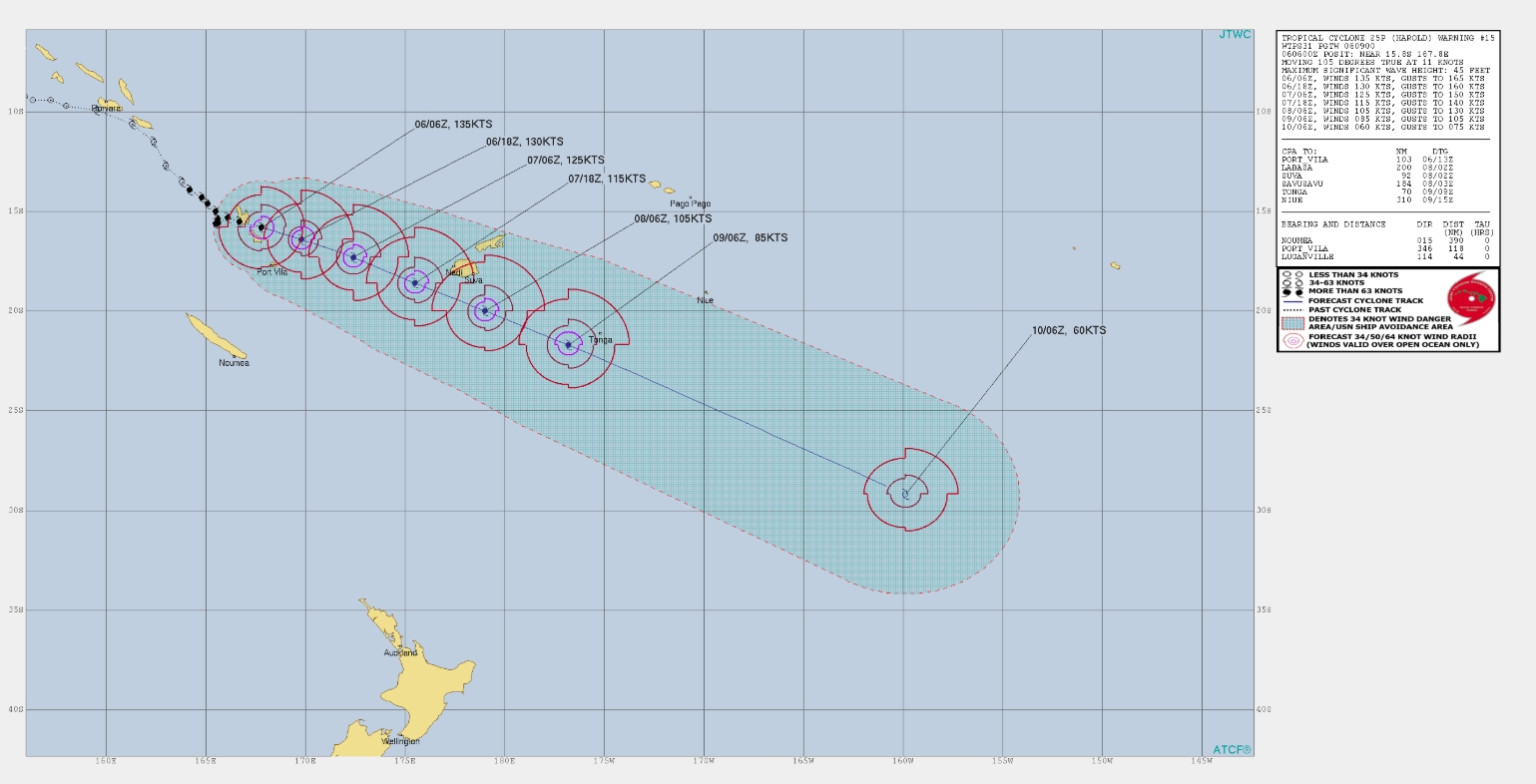
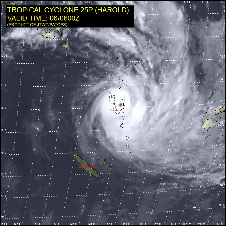
Image credit: JTWC/SATOPS
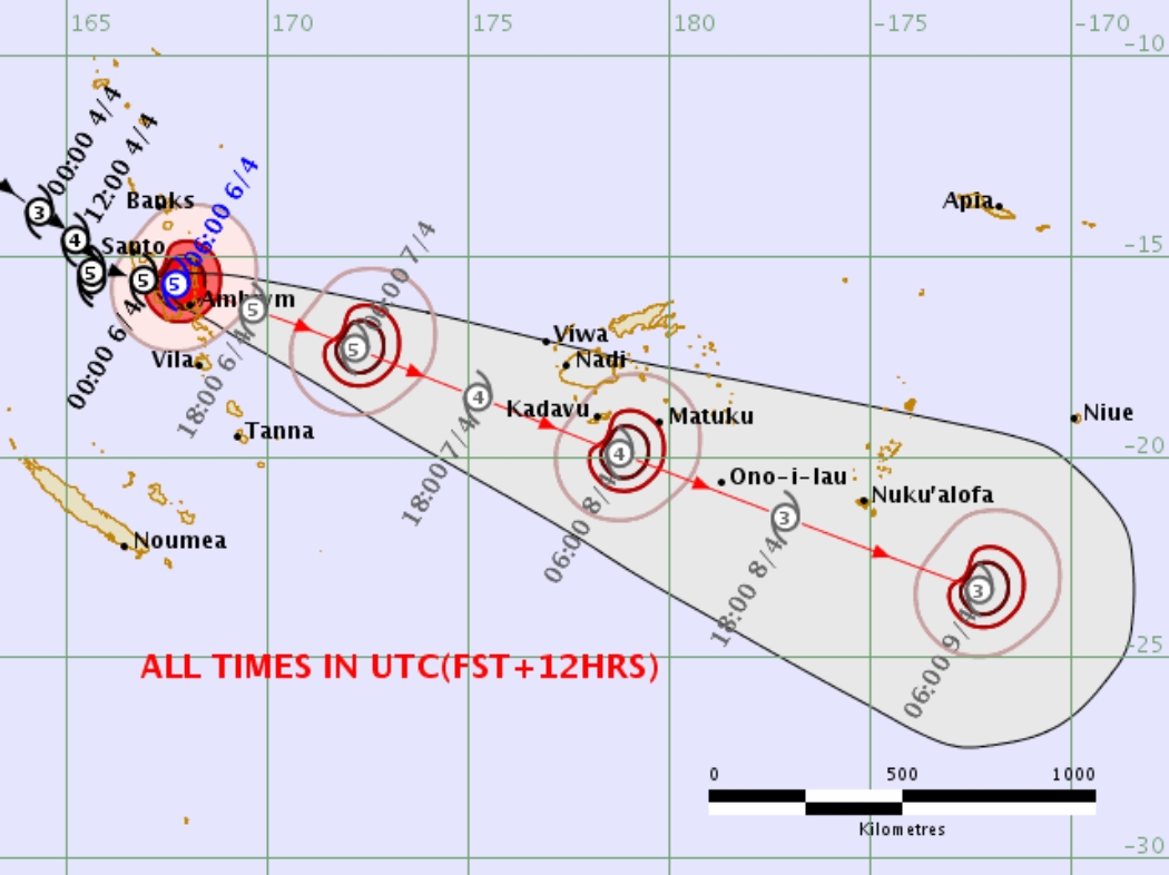
Image credit: Fiji Met
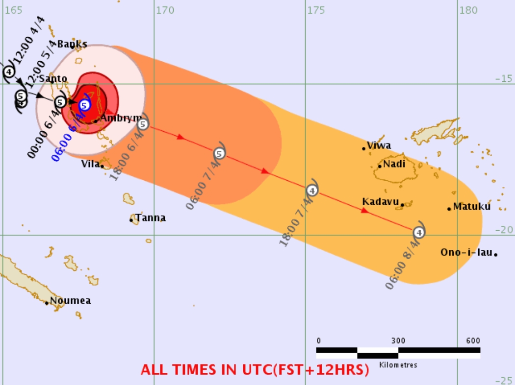
Image credit Fiji Met
"Very rough to phenomenal seas with heavy to phenomenal swells are expected over northern and central open and coastal waters tonight as the system continues to move over the Central Islands of Vanuatu," VMGD added.
"High Seas wind warning and a Marine strong wind warning are current for all coastal and open waters of Vanuatu. People, including seagoing vessels, are strongly advised not to go out to sea within the affected area until the system has moved out of the area."
Harold is expected to continue moving southeast and pass close to Kandavu Island by April 8.
Category 5 Severe Tropical Cyclone #Harold at sunset #CycloneHarold pic.twitter.com/2qK5PepNtB
— Zoom Earth (@zoom_earth) April 6, 2020
From exiting #EspirituSanto, to landfall on #Pentecost, Cyclone Harold underwent an absolute explosion in intensity. This storm is likely at Category 5 intensity above 160MPH.
A truly devastating impact. and it's still getting stronger. #CycloneHarold #Harold #Cyclone pic.twitter.com/rmaWoAmSVC— Alex Lubbers (@AlexLubbers2) April 6, 2020
Tropical #CycloneHarold: category 5 with wind gusts over 275 km/h about to make landfall in Espiritu Santo, #Vanuatu.
• 4th severe tropical cyclone this season.
• First category 5 since Gita in 2018.
• Strongest cyclone in Vanuatu since Pam in 2015. pic.twitter.com/066W66HcNd
— Island Climate Update (@ICU_NIWA) April 5, 2020
Prior to the storm's landfall in Vanuatu, 28 people aboard a ferry went missing in the Solomon Islands due to rough seas. The police have retrieved seven bodies so far — the search operation continues for 21 others missing.
Commenting rules and guidelines
We value the thoughts and opinions of our readers and welcome healthy discussions on our website. In order to maintain a respectful and positive community, we ask that all commenters follow these rules.