
Powerful fall storm slams New England and the Maritimes, leaving nearly 600 000 customers without power
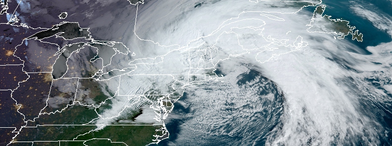
Featured image: Powerful fall storm over New England at 13:00 UTC on October 17, 2019. Credit: NOAA/GOES-East
A powerful fall storm affecting the United States from Mid-Atlantic to New England and the Canadian Maritimes will continue to deliver strong winds, locally heavy rain, and numerous coastal hazards today. Power cuts have already affected nearly 600 000 customers, mostly in the United States.
The storm rapidly intensified Wednesday night into Thursday, October 17 (underwent bombogenesis, why some media are calling it bomb cyclone), bringing heavy rain, high-elevation snow and hurricane-force winds.
"The storm strengthened at a fast enough pace into Thursday to be classified as a bomb cyclone. For a storm to meet bomb cyclone criteria, the barometric pressure has to fall at least 24 millibars, or 0.71 of an inch of Mercury, in 24 hours," AccuWeather meteorologist Alex Sosnowski noted.
An almost 12-hour infrared GOES-East satellite loop of the Northeast #BombCyclone. (Credit: NOAA, CIRA/RAMMB) pic.twitter.com/EbBWKM6Afd
— Jonathan Erdman (@wxjerdman) October 17, 2019
Several preliminary low pressure records were broken, Sosnowski added.
Providence, Rhode Island, set a new monthly record reaching 976.3 hPa at 03:54 LT. Thursday. Preliminary October records were also set in Boston and Concord, New Hampshire. Boston reached 975.3 hPa, surpassing the previous record of 982.4 hPa, while in Concord, the pressure dipped to 973.1 hPa, breaking the old record of 980.4 hPa. The National Weather Service will ultimately determine the validity of these records.
Since winds on the front side of the storm were from the east or southeast, instead of the northeast for New England, the system is not being considered as a true nor'easter, Sosnowski said.
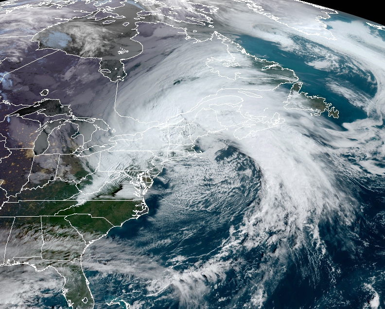
Image credit: NOAA/GOES-East
Trees and powerlines were downed mostly in southeast New England, where wind gusts of 145 km/h (90 mph) were recorded, as well as in 6 other states.
While wind gusts are now subsiding, nearly 550 000 customers are still without power – 221 000 in Maine, 218 000 in Massachusetts, 38 000 in Connecticut, 35 000 in Rhode Island and 33 000 in New Hampshire. At least 16 000 customers are without power in the Maritimes.
The storm will continue to bring heavy rainfall, gusty winds, and coastal erosion to parts of New England through Thursday before lifting quickly into eastern Canada by Friday, October 18, NWS said. Rain and possible higher elevation snow showers may linger into Friday for portions of interior New England.
Behind this system, temperatures should be rather cool for October standards, with daytime highs as much as 10 to 20 degrees below normal for much of the Appalachians into the Northeast.
Below normal temperatures also extend southward towards the Gulf Coast as well.
I'm a dedicated researcher, journalist, and editor at The Watchers. With over 20 years of experience in the media industry, I specialize in hard science news, focusing on extreme weather, seismic and volcanic activity, space weather, and astronomy, including near-Earth objects and planetary defense strategies. You can reach me at teo /at/ watchers.news.
Commenting rules and guidelines
We value the thoughts and opinions of our readers and welcome healthy discussions on our website. In order to maintain a respectful and positive community, we ask that all commenters follow these rules.