
Heavy rain, flash flooding hits Dallas, parts of North Texas
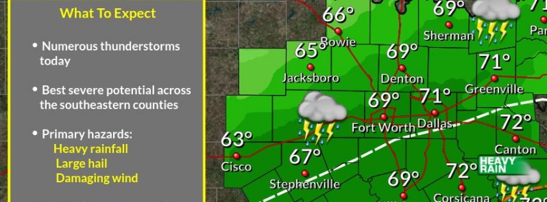
Image credit: NWS Fort Worth
Severe thunderstorms hit North Texas on April 23 and 24, 2019, flooding roadways and causing power outages across the region.
Dallas Love Field received 83.8 mm (3.3 inches) of rain overnight, flooding the lower levels of the airport's garages and reaching the roofs of some cars. During the same period, Carrolton, The Colony and Farmers Branch recorded up to 101.6 mm (4 inches) of rain.
Dallas' director of aviation said the flooding was caused by a stormwater outflow that's too narrow to handle that much water in a short time.
Rain is still coming down in North Texas this morning. Flash flood watch remains in effect until midnight tonight for an additional 2-3" of rain on top of what has already fallen. Be safe. #NBCDFWWeather pic.twitter.com/1kE8qUT3oA
— Keisha Burns (@KeishaBurnsNBC5) April 24, 2019
Dozens of cars parked at the Dallas Love Field Airport garage were flooded this morning due to heavy rain. Details: https://t.co/J612hMDlXm #NBCDFWWeather pic.twitter.com/lku4d9xUoS
— NBCDFW Weather (@NBCDFWWeather) April 24, 2019
Ominous skies and sheer over #Dallas this morning. #TXwx @NWSFortWorth @JimCantore @Ginger_Zee @WeatherNation @weatherchannel @EarthandClouds @yourtake @StormHour pic.twitter.com/aWa02WYq47
— eweather (@Eweather13) April 24, 2019
52 knots here at DFW!! Here’s what it looks like from the plane! pic.twitter.com/JIZaQnu4AE
— Ariel Cohen (@BuckeyeTSTM) April 24, 2019
While terminals at the airport were not affected, about 60 flights had been canceled along with at least 24 at Dallas-Fort Worth International Airport.
Some 28 000 customers were affected by power outages.
A threat for strong to severe thunderstorms with additional heavy rainfall and localized flooding remains into tonight across central and eastern Texas, NWS warns.
The threat for severe thunderstorms and heavy rainfall will move to the central Gulf Coast on Thursday, April 25.
Meanwhile, temperatures throughout much of the country will be very warm, especially over the Desert Southwest, where records are possible.
Another day of rain & storms is expected across most of the region. The best severe potential will be across the southeastern counties. Total rainfall accumulations of upwards of 2" are possible across Central Texas as the heavy rain axis shifts southward. #dfwwx #ctxwx #txwx pic.twitter.com/OMZg8WLwmZ
— NWS Fort Worth (@NWSFortWorth) April 24, 2019
A Flash Flood Watch remains in effect through this evening & has been expanded to include counties east of I-35. Widespread 2-4 inches expected with localized amounts higher than 5 inches. Drive with caution during your morning & afternoon commute! #dfwwx #ctxwx #txwx pic.twitter.com/s3evM6fbiB
— NWS Fort Worth (@NWSFortWorth) April 24, 2019
I'm a dedicated researcher, journalist, and editor at The Watchers. With over 20 years of experience in the media industry, I specialize in hard science news, focusing on extreme weather, seismic and volcanic activity, space weather, and astronomy, including near-Earth objects and planetary defense strategies. You can reach me at teo /at/ watchers.news.
Commenting rules and guidelines
We value the thoughts and opinions of our readers and welcome healthy discussions on our website. In order to maintain a respectful and positive community, we ask that all commenters follow these rules.