
Tropical Storm “Gordon” makes landfall just west of Alabama-Mississippi border
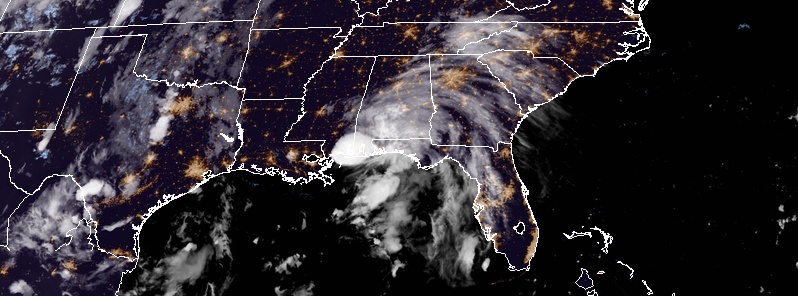
Featured image: Tropical Storm "Gordon" at 03:00 UTC on September 5, 2018. Credit: NOAA/GOES-East
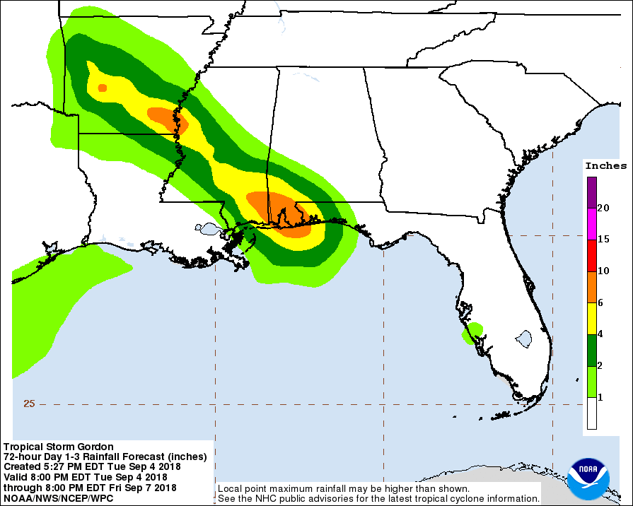
Tropical Storm "Gordon" made landfall just west of the Alabama-Mississippi border at 03:15 UTC on September 5, 2018 (22:15 CDT, September 4) with estimated maximum sustained winds of 110 km/h (70 mph) and minimum central pressure of 997 hPa. The storm is expected to bring life-threatening storm surge and hurricane conditions to portions of the central Gulf Coast, where a Storm Surge Warning and Hurricane Warning are in effect. The highest storm surge is expected along the coasts of Mississippi and Alabama from Biloxi to Dauphin Island. Heavy rainfall from Gordon will affect the western Florida Panhandle, southwest Alabama, southern and central Mississippi, northeastern Louisiana, and southern Arkansas, where totals could reach as high as 305 mm (12 inches). This rainfall will cause flash flooding in portions of these areas.
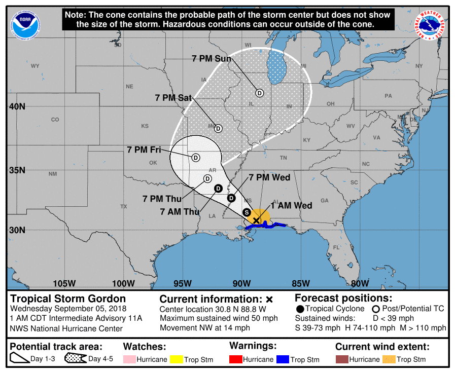
At 06:00 UTC on September 5, the center of Tropical Storm "Gordon" was located 70 km (40 miles) of Mobile, Alabama. The system had maximum sustained winds of 85 km/h (50 mph) and minimum central pressure of 1 002 hPa. It was moving NW at 22 km/h (14 mph).
On the forecast track, the center of Gordon will move across the lower Mississippi Valley through Wednesday, September 5. Some decrease in forward speed is expected over the next couple of days, followed by a turn toward the north-northwest and north on Friday, September 7.
Continued rapid weakening is expected while the system moves over land, and Gordon is forecast to become a tropical depression later this morning (CDT).
Tropical-storm-force winds extend outward up to 130 km (80 miles) from the center.
The combination of a dangerous storm surge and the tide will cause normally dry areas near the coast to be flooded by rising waters moving inland from the shoreline. The water could reach the following heights above ground somewhere in the indicated areas if the peak surge occurs at the time of high tide:
Mouth of the Mississippi River to Biloxi: 30 – 90 cm (1 to 3 feet).
Biloxi to the Alabama/Florida Border including Mobile Bay: 60 – 120 cm (2 to 4 feet).
Alabama/Florida Border to Navarre, Florida: 30 – 90 cm (1 to 3 feet).
The deepest water will occur along the immediate coast near and to the east of the landfall location, where the surge will be accompanied by large waves. Surge-related flooding depends on the relative timing of the surge and the tidal cycle, and can vary greatly over short distances.
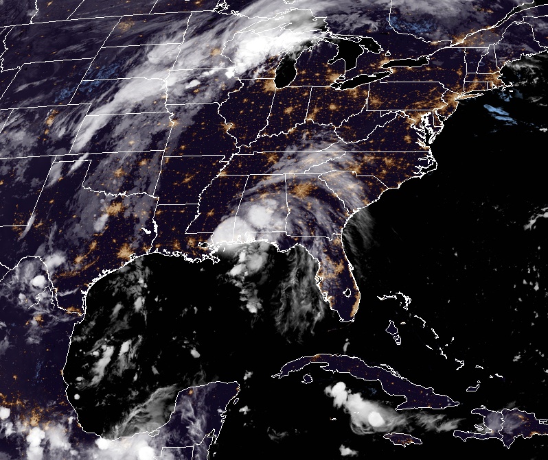
Tropical Storm "Gordon" at 04:30 UTC on September 5, 2018. Credit: NOAA/GOES-East
Gordon is expected to produce total rain accumulations of 102 – 204 mm (4 to 8 inches) over the western Florida Panhandle, southwest Alabama, southern and central Mississippi, northeastern Louisiana, and southern Arkansas, with isolated maximum amounts of 305 mm (12 inches) through late Thursday, September 6.
This rainfall will cause flash flooding across portions of these areas.
A couple of tornadoes are possible tonight near the coasts of Alabama and the western Florida Panhandle.
Update:
The Escambia County Sheriff's Office stated on Tuesday night that a child in Pensacola, Florida, was killed after a tree toppled over onto a mobile home, leaving the front of the structure crushed.
I'm a dedicated researcher, journalist, and editor at The Watchers. With over 20 years of experience in the media industry, I specialize in hard science news, focusing on extreme weather, seismic and volcanic activity, space weather, and astronomy, including near-Earth objects and planetary defense strategies. You can reach me at teo /at/ watchers.news.
Commenting rules and guidelines
We value the thoughts and opinions of our readers and welcome healthy discussions on our website. In order to maintain a respectful and positive community, we ask that all commenters follow these rules.