
Shallow M6.0 earthquake hits Kermanshah, killing at least 3 people and injuring over 300, Iran
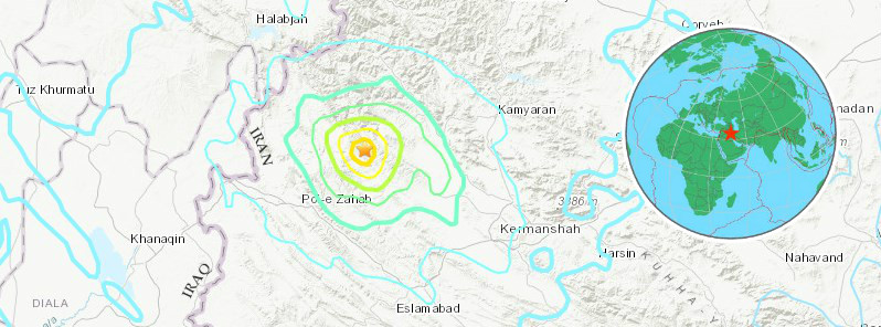
Image credit: USGS, EMSC
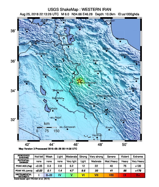
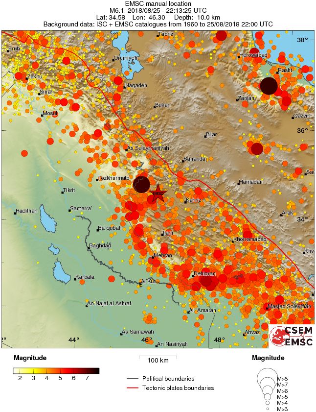
At least 3 people have been killed and more than 300 were injured after M6.0 earthquake hit western Iran at 22:13 UTC on August 25, 2018 (02:43 local time, August 26). USGS is reporting a depth of 10 km (6.2 miles). EMSC is reporting M6.1 at a depth of 10 km. The Iranian Seismological Center is reporting M5.9 at a depth of 8 km (5 miles). The quake was followed by at least 5 M4+ aftershocks and numerous smaller ones.
The same region was hit by M7.3 earthquake on November 12, 2017, in which at least 530 people were killed and 10 018 injured.
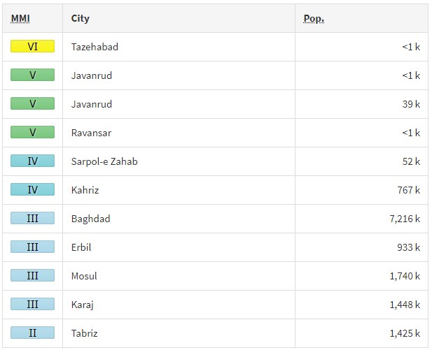
According to the USGS, the epicenter of August 25th earthquake was located 14.4 km (9 miles) SE of Tāzehābād (population 0), 26.5 km (16.4 miles) SW of Javānrūd (population 38 657), 42.8 km (26.6 miles) S of Pāveh (population 17 779), 44.2 km (27.4 miles) ENE of Sarpol-e Z̄ahāb (population 51 611), and 82 km (51 miles) WNW Kermanshah (population 621 100), Iran.
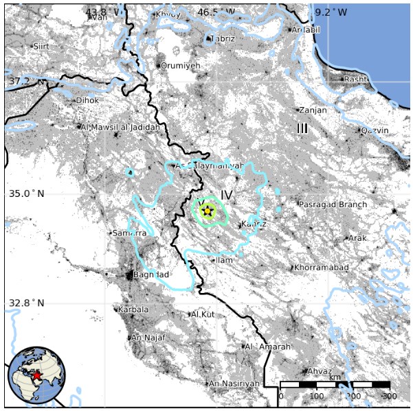
There are 3 280 000 people living within 100 km (62 miles).
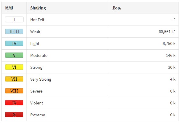
Some 4 000 people are estimated to have felt very strong shaking, 30 000 strong, 146 000 moderate, 6 750 000 light and 68 561 000 weak.
The USGS issued a yellow alert for shaking-related fatalities. Some casualties are possible and the impact should be relatively localized. Past events with this alert level have required a local or regional level response.
Overall, the population in this region resides in structures that are highly vulnerable to earthquake shaking, though some resistant structures exist. The predominant vulnerable building types are adobe block and low-rise nonductile concrete frame with infill construction.
Recent earthquakes in this area have caused secondary hazards such as landslides that might have contributed to losses.
Little to no landsliding and liquefaction is expected, but could still have occurred in highly susceptible areas.
Estimated population exposure to earthquake shaking
Selected cities exposed
Regional seismicity
Updates
State-run television station IRIB said the town of Tazehabad on the border with Iraq was the worst hit and that rescue teams were on their way there.
At least 3 people have been killed and 310 injured. The death toll is expected to rise.
The head of the emergency department Kermanshah University of Medical Sciences, Saeb Sharidari, told state news agency IRNA that six people were in critical condition.
The provincial head of the Red Crescent, Mohammad Reza Amirian, said there were potential problems with drinking water due to damaged infrastructure in villages, but that it had not yet been necessary to distribute food and tents.
Kermanshah governor Houshang Bazvand told the Tasnim news agency that electricity had been temporarily cut to several villages. A crisis center was set up, with hospitals and relief organizations placed on alert.
Seismotectonics of the Middle East and vicinity
No fewer than four major tectonic plates (Arabia, Eurasia, India, and Africa) and one smaller tectonic block (Anatolia) are responsible for seismicity and tectonics in the Middle East and surrounding region. Geologic development of the region is a consequence of a number of first-order plate tectonic processes that include subduction, large-scale transform faulting, compressional mountain building and crustal extension.
Mountain building in northern Pakistan and Afghanistan is the result of compressional tectonics associated with collision of the India plate moving northwards at a rate of 40 mm/yr with respect to the Eurasia plate. Continental thickening of the northern and western edge of the India subcontinent has produced the highest mountains in the world, including the Himalayan, Karakoram, Pamir and Hindu Kush ranges. Earthquake activity and faulting found in this region, as well as adjacent parts of Afghanistan and India, are due to collisional plate tectonics.
Beneath the Pamir-Hindu Kush Mountains of northern Afghanistan, earthquakes occur to depths as great as 200 km as a result of remnant lithospheric subduction. Shallower crustal earthquakes in the Pamir-Hindu Mountains occur primarily along the Main Pamir Thrust and other active Quaternary faults, which accommodate much of the region's crustal shortening. The western and eastern margins of the Main Pamir Thrust display a combination of thrust and strike-slip mechanisms.
Along the western margin of the Tibetan Plateau, in the vicinity of southeastern Afghanistan and western Pakistan, the India plate translates obliquely relative to the Eurasia plate, resulting in a complex fold-and-thrust belt known as the Sulaiman Range. Faulting in this region includes strike-slip, reverse-slip and oblique-slip motion and often results in shallow, destructive earthquakes. The relatively fast moving left-lateral, strike-slip Chaman Fault system in southeastern Afghanistan accommodates translational motion between the India and Eurasia plates. In 1505, a segment of the Chaman Fault system near Kabul, Afghanistan ruptured causing widespread destruction of Kabul and surrounding villages. In the same region, the more recent 30 May 1935, M7.6 Quetta, Pakistan earthquake, occurred within the Sulaiman Range, killing between 30,000 and 60,000 people.
Off the south coast of Pakistan and southeast coast of Iran, the Makran trench is the present-day surface expression of active subduction of the Arabia plate beneath the continental Eurasia plate, which converge at a rate of approximately 20 mm/yr. Although the Makran subduction zone has a relatively slow convergence rate, it has produced large devastating earthquakes and tsunamis. For example, the November 27, 1945 M8.0 mega-thrust earthquake produced a tsunami within the Gulf of Oman and Arabia Sea, killing over 4,000 people. Northwest of this active subduction zone, collision of the Arabia and Eurasia plates forms the approximately 1,500-km-long fold and thrust belt of the Zagros Mountains, which crosses the whole of western Iran and extends into northeastern Iraq. Collision of the Arabia and Eurasia plates also causes crustal shortening in the Alborz Mountains and Kopet Dag in northern Iran. Eastern Iran experiences destructive earthquakes that originate on both strike-slip and reverse faults. For example, the 16 September 1978 M7.8 earthquake, along the southwest edge of the Dasht-e-Lut Basin killed at least 15,000 people.
Along the eastern margin of the Mediterranean region there is complex interaction between the Africa, Arabia and Eurasia plates. The Red Sea Rift is a spreading center between the Africa and Arabia plates, with a spreading rate of approximately 10mm/yr near its northern end, and 16mm/yr near its southern end (Chu, D. and Gordon, R. G., 1998). Seismicity rate and size of earthquakes has been relatively small along the spreading center, but the rifting process has produced a series of volcanic systems across western Saudi Arabia.
Further north, the Red Sea Rift terminates at the southern boundary of the Dead Sea Transform Fault. The Dead Sea Transform is a strike-slip fault that accommodates differential motion between the Africa and Arabia plates. Though both the Africa plate, to the west, and the Arabia plate, to the east, are moving in a NNE direction, the Arabia plate is moving slightly faster, resulting in the left-lateral, strike-slip motion along this segment of the plate boundary. Historically, earthquake activity along the Dead Sea Transform has been a significant hazard in the densely populated Levant region (eastern Mediterranean). For example, the November 1759 Near East earthquake is thought to have killed somewhere between 2,000-20,000 people. The northern termination of the Dead Sea Transform occurs within a complex tectonic region of southeast Turkey, where interaction of the Africa and Arabia plates and the Anatolia block occurs. This involves translational motion of the Anatolia Block westwards, with a speed of approximately 25mm/yr with respect to Eurasia, in order to accommodate closure of the Mediterranean basin.
The right-lateral, strike-slip North Anatolia Fault, in northern Turkey, accommodates much of the westwards motion between the Anatolia Block and Eurasia Plate. Between 1939 and 1999, a series of devastating M7.0+ strike-slip earthquakes propagated westwards along the North Anatolia Fault system. The westernmost of these earthquakes was the 17th August 1999, M7.6 Izmit earthquake, near the Sea of Marmara, killed approximately 17,000 people.
At the southern edge of the Anatolia Block lies the east-west trending Cyprian Arc with associated levels of moderate seismicity. The Cyprian Arc represents the convergent boundary between the Anatolia Block to the north and the Africa Plate to the south. The boundary is thought to join the East Anatolia Fault zone in eastern Turkey; however no certain geometry or sense of relative motion along the entire boundary is widely accepted. (USGS)
I'm a dedicated researcher, journalist, and editor at The Watchers. With over 20 years of experience in the media industry, I specialize in hard science news, focusing on extreme weather, seismic and volcanic activity, space weather, and astronomy, including near-Earth objects and planetary defense strategies. You can reach me at teo /at/ watchers.news.
Commenting rules and guidelines
We value the thoughts and opinions of our readers and welcome healthy discussions on our website. In order to maintain a respectful and positive community, we ask that all commenters follow these rules.