
Extremely dangerous M7.3 earthquake hits Iran-Iraq border region – 530 killed, 10 018 injured
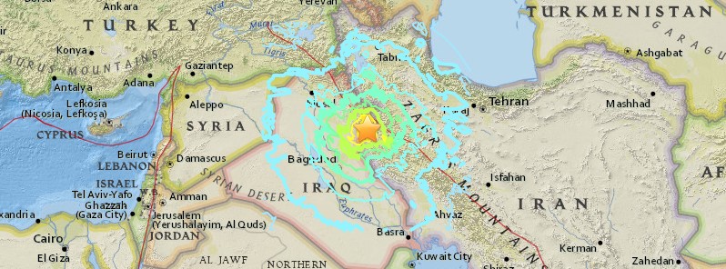
Image credit: USGS
A very strong and shallow earthquake registered by the USGS as M7.3 hit Iran – Iraq border region at 18:18 UTC (21:18 local time) on Sunday, November 12, 2017. The agency is reporting a depth of 23.2 km (14.4 miles). EMSC is reporting M7.2 at a depth of 19 km (11.8 miles). This earthquake can have a high humanitarian impact based on the magnitude and the affected population and their vulnerability.
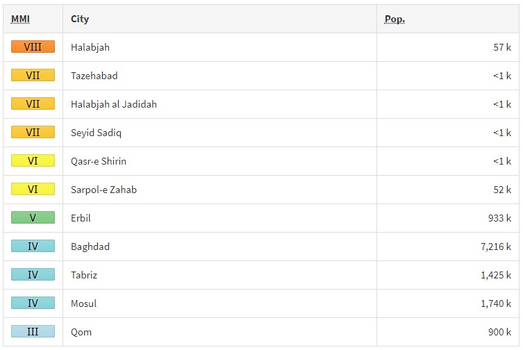
According to the USGS, the epicenter was located 22.4 km (13.9 miles) SSE of Derbendîxan (population 0), Iraq, 25.1 km (15.6 miles) NW of Tāzehābād (population 0), Iran, 32.6 km (20.2 miles) SSW of Ḩalabjah (population 57 333), Iraq, 52.4 km (32.6 miles) N of Sarpol-e Z̄ahāb (population 51 611), Iran and 52.9 km (32.9 miles) WSW of Pāveh (population 17 779), Iran.
There are 2 580 000 people living within 100 km (62 miles) and 340 000 within 50 km (31 miles).
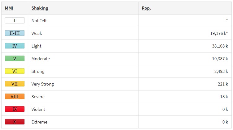
Some 18 000 people are estimated to have felt severe shaking, 221 000 very strong, 2 493 000 strong, 10 387 000 moderate and 38 108 000 weak.
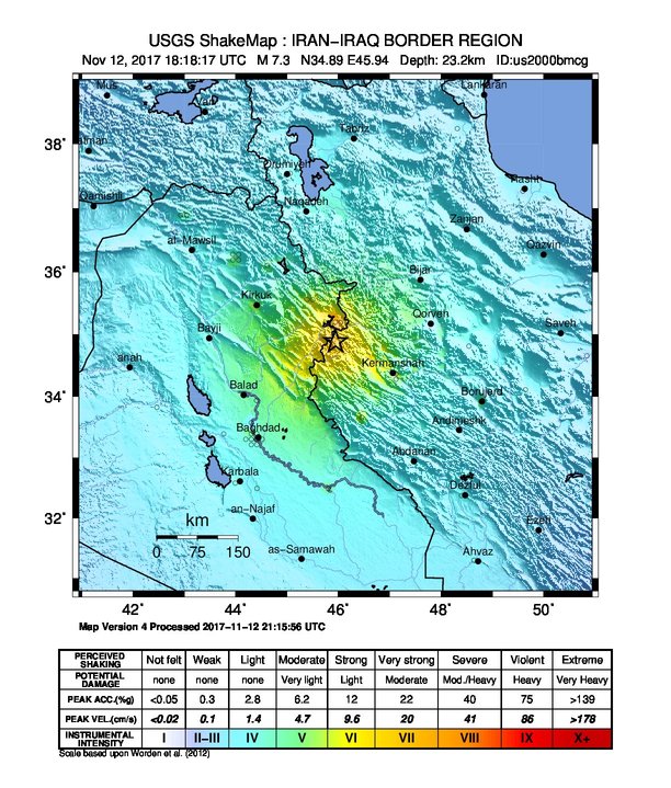
USGS issued an orange alert for shaking-related fatalities and economic losses. Significant casualties and damage are likely and the disaster is potentially widespread. Past orange alerts have required a regional or national level response.
Overall, the population in this region resides in structures that are highly vulnerable to earthquake shaking, though some resistant structures exist. The predominant vulnerable building types are adobe block and low-rise nonductile concrete frame with infill construction.
Recent earthquakes in this area have caused secondary hazards such as landslides that might have contributed to losses.
Estimated population exposure to earthquake shaking
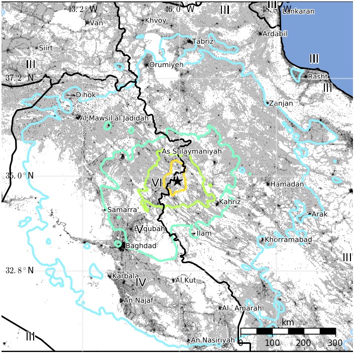
Selected cities exposed
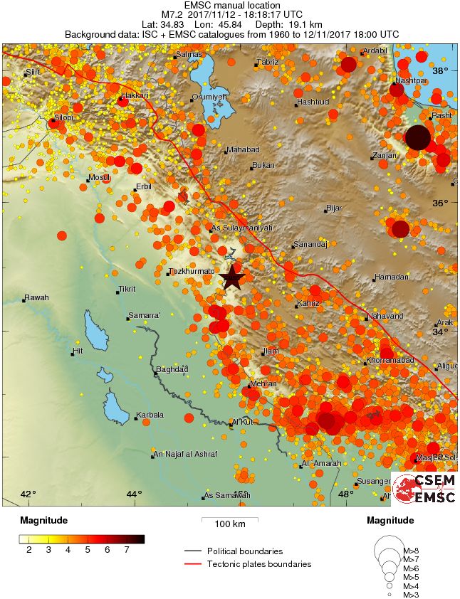
Regional seismicity
Updates
November 12 @ 19:39 UTC
Shaking was felt in Iraq, Iran, Turkey, Syria, Kuwait, Jordan, Israel, UAE, Armenia, Azerbaijan, and Georgia.
19:43 UTC
At least 4 people have died and 16 have been injured in the Province of Erbil, Iraq.
Professor Max Wyss, who specializes in theoretical prognoses of injuries and fatalities expects 200 to 3 000 people injured and 50 to 1 000 fatalities (ER).
Material damages captured by Rudaw English's managing editor @OsamaGolpy in #Halabja #earthquake pic.twitter.com/6MaFWai7Vb
— Rudaw English (@RudawEnglish) November 12, 2017
Video del momento en que el terremoto golpea en el norte de #Iraq #Sulaymaniye #earthquake pic.twitter.com/ytXSDmKEFM
— Tilapia ن (@_Iogan) November 12, 2017
Powerfull #Earthquake IRAK M 7.2 – 32km S-Halabjah 34 km depth Ph 64 P. Eurasia-Arabia[Rev] 18:18:19UTC
Nuclear Reactor near (w/conf) pic.twitter.com/ff6RT77mRD— ™ (@PeruTwiter) November 12, 2017
November 13 @ 17:52 UTC
The death toll rose to 460 and the number of injured to 7 721.
The number of casualties is expected to rise.
Numerous aftershocks have been reported.
#عاجل اضرار بالمباني نتيجة #الهزة_الارضية في محافظة #السليمانية شمال #العراق #هزة_أرضية_في_العراق
pic.twitter.com/pdc4KecYRt— هاشتاك العراق (@hishtaqiraq) November 12, 2017
More than 142 of the victims were in Sarpol-e Zahab county in Kermanshah, Iran about 15 km (10 miles) from the Iraq border. The main hospital in the capital of the county was severely damaged and could not treat hundreds of injured people who were taken there, the head of the Iranian emergency services, Pirhossein Koulivand said.
Kurdish health officials said at least four people were killed in Iraq and at least 50 injured.
December 1 @ 09:07 UTC
The death toll stands at 530 and the number of injured at 10 018.
Tectonic summary
The November 12, 2017 M7.3 earthquake near the Iran-Iraq border in northwest Iran (220 km / 136 miles northeast of Baghdad, Iraq) occurred as the result of oblique-thrust faulting at mid-crustal depth (~25 km / ~15 mi). Preliminary focal mechanism solutions for the event indicate rupture occurred on a fault dipping shallowly to the east-northeast, or on a fault dipping steeply to the southwest. At the location of this earthquake, the Arabia plate is moving towards the north with respect to Eurasia at a rate of about 26 mm/yr. The two plates converge along a northwest-striking plate boundary in the general vicinity of this earthquake, driving the uplift of the Zagros mountains in Iran. The location of the event and the shallow, northeast-dipping plane of the focal mechanism solution are consistent with rupture of a plate boundary related structure in this region.
While commonly plotted as points on maps, earthquakes of this size are more appropriately described as slip over a larger fault area. Oblique-thrust-faulting events of the size of the November 12th, 2017 earthquake are typically about 65×25 km / 40×15 mi (length x width).
Over the preceding century, the region within 250 km (155 miles) of the hypocenter of the November 12, 2017 earthquake has experienced 4 other M6+ earthquakes. The most recent of these was a 6.1 earthquake about 100 km (62 miles) to the south of the November 2017 event in January 1967. In the late 1950s and early 1960s, a cluster of M6.0-6.7 earthquakes occurred along the plate boundary about 200 km (124 miles) to the southeast of today’s earthquake. In November 2013, a pair of M5.6 and M5.8 earthquakes occurred about 60 km (37 miles) south of the November 2017 event. They are not known to have caused significant damage or fatalities.
A M7.4 earthquake in June 1990, 400 km (248 miles) to the northeast of the November 12, 2017 event, caused between 40 000 – 50 000 fatalities, more than 60 000 injuries, and left more than 600 000 homeless in the in the Rasht-Qazvin-Zanjan area of Iran.
Seismotectonics of the Middle East and vicinity
No fewer than four major tectonic plates (Arabia, Eurasia, India, and Africa) and one smaller tectonic block (Anatolia) are responsible for seismicity and tectonics in the Middle East and surrounding region. Geologic development of the region is a consequence of a number of first-order plate tectonic processes that include subduction, large-scale transform faulting, compressional mountain building and crustal extension.
Mountain building in northern Pakistan and Afghanistan is the result of compressional tectonics associated with collision of the India plate moving northwards at a rate of 40 mm/yr with respect to the Eurasia plate. Continental thickening of the northern and western edge of the India subcontinent has produced the highest mountains in the world, including the Himalayan, Karakoram, Pamir and Hindu Kush ranges. Earthquake activity and faulting found in this region, as well as adjacent parts of Afghanistan and India, are due to collisional plate tectonics.
Beneath the Pamir-Hindu Kush Mountains of northern Afghanistan, earthquakes occur to depths as great as 200 km as a result of remnant lithospheric subduction. Shallower crustal earthquakes in the Pamir-Hindu Mountains occur primarily along the Main Pamir Thrust and other active Quaternary faults, which accommodate much of the region's crustal shortening. The western and eastern margins of the Main Pamir Thrust display a combination of thrust and strike-slip mechanisms.
Along the western margin of the Tibetan Plateau, in the vicinity of southeastern Afghanistan and western Pakistan, the India plate translates obliquely relative to the Eurasia plate, resulting in a complex fold-and-thrust belt known as the Sulaiman Range. Faulting in this region includes strike-slip, reverse-slip and oblique-slip motion and often results in shallow, destructive earthquakes. The relatively fast moving left-lateral, strike-slip Chaman Fault system in southeastern Afghanistan accommodates translational motion between the India and Eurasia plates. In 1505, a segment of the Chaman Fault system near Kabul, Afghanistan ruptured causing widespread destruction of Kabul and surrounding villages. In the same region, the more recent 30 May 1935, M7.6 Quetta, Pakistan earthquake, occurred within the Sulaiman Range, killing between 30,000 and 60,000 people.
Off the south coast of Pakistan and southeast coast of Iran, the Makran trench is the present-day surface expression of active subduction of the Arabia plate beneath the continental Eurasia plate, which converge at a rate of approximately 20 mm/yr. Although the Makran subduction zone has a relatively slow convergence rate, it has produced large devastating earthquakes and tsunamis. For example, the November 27, 1945 M8.0 mega-thrust earthquake produced a tsunami within the Gulf of Oman and Arabia Sea, killing over 4,000 people. Northwest of this active subduction zone, collision of the Arabia and Eurasia plates forms the approximately 1,500-km-long fold and thrust belt of the Zagros Mountains, which crosses the whole of western Iran and extends into northeastern Iraq. Collision of the Arabia and Eurasia plates also causes crustal shortening in the Alborz Mountains and Kopet Dag in northern Iran. Eastern Iran experiences destructive earthquakes that originate on both strike-slip and reverse faults. For example, the 16 September 1978 M7.8 earthquake, along the southwest edge of the Dasht-e-Lut Basin killed at least 15,000 people.
Along the eastern margin of the Mediterranean region there is complex interaction between the Africa, Arabia and Eurasia plates. The Red Sea Rift is a spreading center between the Africa and Arabia plates, with a spreading rate of approximately 10mm/yr near its northern end, and 16mm/yr near its southern end (Chu, D. and Gordon, R. G., 1998). Seismicity rate and size of earthquakes has been relatively small along the spreading center, but the rifting process has produced a series of volcanic systems across western Saudi Arabia.
Further north, the Red Sea Rift terminates at the southern boundary of the Dead Sea Transform Fault. The Dead Sea Transform is a strike-slip fault that accommodates differential motion between the Africa and Arabia plates. Though both the Africa plate, to the west, and the Arabia plate, to the east, are moving in a NNE direction, the Arabia plate is moving slightly faster, resulting in the left-lateral, strike-slip motion along this segment of the plate boundary. Historically, earthquake activity along the Dead Sea Transform has been a significant hazard in the densely populated Levant region (eastern Mediterranean). For example, the November 1759 Near East earthquake is thought to have killed somewhere between 2,000-20,000 people. The northern termination of the Dead Sea Transform occurs within a complex tectonic region of southeast Turkey, where interaction of the Africa and Arabia plates and the Anatolia block occurs. This involves translational motion of the Anatolia Block westwards, with a speed of approximately 25mm/yr with respect to Eurasia, in order to accommodate closure of the Mediterranean basin.
The right-lateral, strike-slip North Anatolia Fault, in northern Turkey, accommodates much of the westwards motion between the Anatolia Block and Eurasia Plate. Between 1939 and 1999, a series of devastating M7.0+ strike-slip earthquakes propagated westwards along the North Anatolia Fault system. The westernmost of these earthquakes was the 17th August 1999, M7.6 Izmit earthquake, near the Sea of Marmara, killed approximately 17,000 people.
At the southern edge of the Anatolia Block lies the east-west trending Cyprian Arc with associated levels of moderate seismicity. The Cyprian Arc represents the convergent boundary between the Anatolia Block to the north and the Africa Plate to the south. The boundary is thought to join the East Anatolia Fault zone in eastern Turkey; however no certain geometry or sense of relative motion along the entire boundary is widely accepted. (USGS)
I'm a dedicated researcher, journalist, and editor at The Watchers. With over 20 years of experience in the media industry, I specialize in hard science news, focusing on extreme weather, seismic and volcanic activity, space weather, and astronomy, including near-Earth objects and planetary defense strategies. You can reach me at teo /at/ watchers.news.
8492 VS very strong and shallow earthquake registered by the USGS as M7.3