
Extremely dangerous Typhoon “Maria” heading toward Ryukyu Islands, Taiwan and China

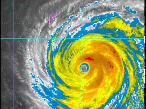
Featured image: Super Typhoon "Maria" at 12:10 UTC on July 9, 2018. Credit: JMA/Himawari-8, CIRA
Very Strong Typhoon "Maria," still a Super Typhoon according to the JTWC, is heading toward Ryukyu Islands, Taiwan and China. Its center is expected to pass right over or very near Miyakojima, Japan around 06:00 UTC on July 10, just north of northern Taiwan and capital Taipei some 12 hours later and make landfall over east-central China with the intensity of around 185 km/h (115 mph), Category 4 hurricane equivalent.
At 09:00 UTC on July 9, the center of Typhoon "Maria" was located approximately 600 km (380 miles) southeast of Okinawa, Japan and has tracked WNW at 31 km/h (20 mph) over the past 6 hours. The cyclone had maximum sustained winds of 240 km/h (150 mph) and gusts to 296 km/h (184 mph). The maximum significant wave height was 12.8 m (42 feet).

The animated multispectral satellite imagery shows a well organized, slightly asymmetric, super typhoon with a well defined 55 km (34 miles) wide eye feature, JTWC meteorologists said.

Super Typhoon "Maria" at 12:10 UTC on July 9, 2018. Credit: JMA/Himawari-8, CIRA
The environmental analysis reveals that Maria is in an area of low vertical wind shear and is tracking through an area of warm sea surface temperatures.
The system is forecast to continue tracking WNW and steadily decrease in intensity as it reaches cooler sea surface temperatures. As it continues on its WNW track, Maria will encounter increasing vertical wind shear due to an approaching mid-latitude trough which will further contribute to the weakening trend.
Maria is expected to make a direct hit or pass dangerously close to Miyakojima, the southern Ryukyu Islands on July 10 as an extremely dangerous Category 4 hurricane equivalent on the Saffir-Simpson Hurricane Wind Scale.


While Maria's center will not pass directly over Taiwan, it will still be close enough to cause significant damage to the nation, especially in its northern regions where gusts could reach 130 – 160 km/h (80 – 100 mph) and up to 250 mm (10 inches) of rain could fall.
Land interaction with northern Taiwan around 21:00 UTC on July 10 will further increase the rate of weakening. However, Maria will still be a very dangerous typhoon (estimated wind speed around 185 km/h / 115 mph, making it a Category 3 hurricane equivalent) when it makes landfall over east-central China late July 10 or early July 11 (UTC).
China's Fujian province has activated an emergency response to cope with the approaching typhoon, the 8th of the year. All fishing boats are ordered to return to the harbor by July 10 afternoon (local time) and all personnel at offshore fish farms to retreat to land by 18:00 local time. In addition, all coastal tourist resorts should also be closed by the same time.
Destructive winds will be accompanied by very heavy rainfall very large waves can devastate homes and communities along the immediate coast.
Maria will rapidly weaken as it tracks northwest over east-central China and the track will shift to the north.

Teo Blašković founded The Watchers in 2011 and edited it until 2026, covering seismic and volcanic activity, extreme weather, space weather and near-Earth objects. Articles on this page are his archive.
Published in the last 24 hours
- Cyclone Akvan weakens after landfall near Gopalpur; more than 300 000 evacuated in Odisha, India
- Male toads abandoned a pond in Italy five days before a deadly 2009 earthquake, while a scientist was counting them Epicenter
- An asteroid was spotted 19 hours before it exploded over Sudan in 2008, and students picked its pieces off the desert Epicenter
- A wave up to 3 m (10 feet) high rose out of Lake Michigan on a sunny June morning in 1954 and swept fishermen off Chicago’s piers, and when a second came 10 days later, warnings had cleared the shore Epicenter
