
Subtropical or tropical cyclone likely to form by late Saturday over the southeastern Gulf of Mexico
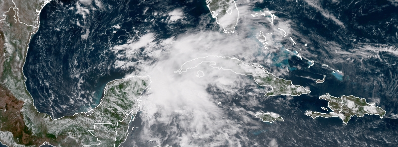
Image credit: NOAA/GOES-East
The National Hurricane Center is monitoring a broad surface low currently drifting slowly northward over the eastern Yucatan Peninsula and becoming better defined. Formation chance over the next 48 hours is 70% and 90% over the next 5 days. This system is expected to bring widespread heavy rain across Cuba, Florida, the Southeast and westward to the central Gulf coast during the Memorial Day weekend. Major flash floods are possible.
A broad surface low drifting slowly northward over the eastern Yucatan Peninsula continues to become better defined, Stacy Stewart, a senior hurricane specialist at NOAA’s National Hurricane Center in Miami noted 17:30 UTC today.
Although showers and thunderstorms, along with strong gusty winds, remain primarily over the adjacent waters of the northwestern Caribbean Sea, environmental conditions are forecast to become more conducive for development through early next week, and a subtropical or tropical depression is likely to form by late Saturday, May 26 over the southeastern Gulf of Mexico.
An Air Force Reserve reconnaissance aircraft is scheduled to investigate the disturbance Friday afternoon, if necessary.
Locally heavy rainfall is forecast across western Cuba and over much of Florida and the northern Gulf Coast into early next week.
In addition, the threat of rip currents will steadily increase along the Gulf coast from Florida westward to Louisiana over the Memorial Day weekend.
The animation below shows the disturbance is located in the vicinity of the Yucatan Peninsula with active convection located just to the east over the Carribean Sea. The latest WPC rainfall forecast maps are shown toward the end of the video.
This system may become trapped over the South, maintaining the tropical moisture fetch into the Southeast well into next week and bringing record-breaking rainfall to some areas.
20 Atlantic Basin storms have developed before the start of June since 1950, according to NOAA's historical hurricane database. That's an average of roughly one storm developing before June 1 every three to four years.
However, preseason storm activity has been an outlier from the norm since 2012, TWC meteorologists said.
Four of the past six years have featured named storms before June 1 in the Atlantic, including 2012, 2015, 2016 and 2017. Two of those years – 2012 and 2016 – featured the genesis of two named storms before June 1.
I'm a dedicated researcher, journalist, and editor at The Watchers. With over 20 years of experience in the media industry, I specialize in hard science news, focusing on extreme weather, seismic and volcanic activity, space weather, and astronomy, including near-Earth objects and planetary defense strategies. You can reach me at teo /at/ watchers.news.
Commenting rules and guidelines
We value the thoughts and opinions of our readers and welcome healthy discussions on our website. In order to maintain a respectful and positive community, we ask that all commenters follow these rules.