
NHC issues tropical storm warnings for parts of Florida, U.S.
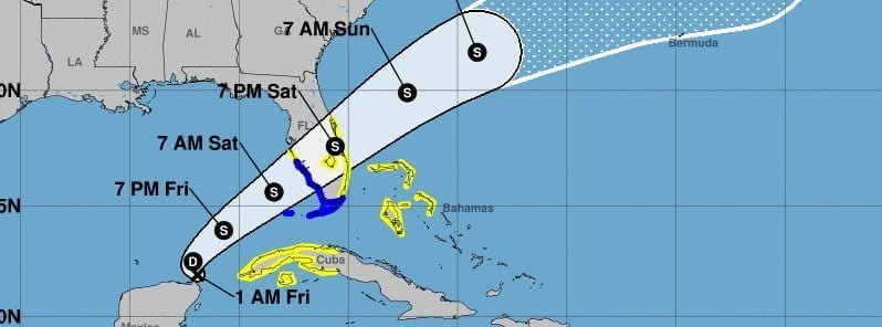
Image credit: NHC
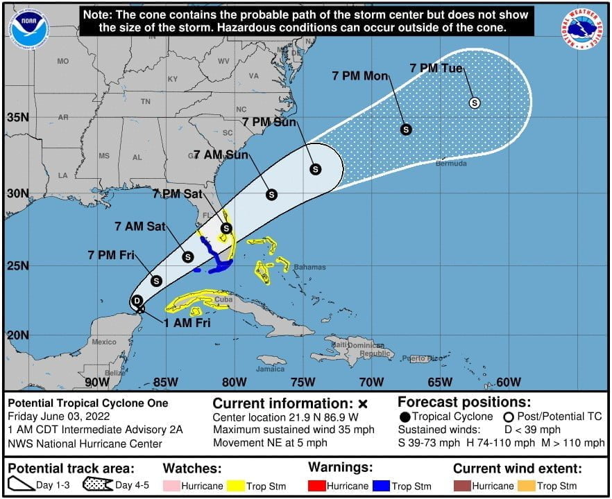
The National Hurricane Center (NHC) has issued a Tropical Storm Warning for all of the Florida Keys, including the Dry Tortugas and Florida Bay, and for the west coast of Florida south of Englewood at 03:00 UTC on June 3, 2022.
- A Tropical Storm Watch is in effect for the west coast of Florida south of the Middle of Longboat Key to Englewood; the east coast of Florida south of the Volusia/Brevard County Line to Card Sound Bridge; Lake Okeechobee; Cuban provinces of Matanzas, Mayabeque, Havana, Artemisa, Pinar del Rio, and the Isle of Youth; and the northwestern Bahamas.
A strengthening tropical system – currently designated Potential Tropical Cyclone ONE, was located about 155 km (95 miles) N of Cozumel, Mexico and 730 km (450 miles) SW of Ft. Myers, Florida at 06:00 UTC today.1
The system had maximum sustained winds near 55 km/h (35 mph), minimum central pressure of 1 003, and was moving NE at 7 km/h (5 mph).
A northeastward motion at a faster forward speed is expected later today and on Saturday, June 4.
On the forecast track, the system should move across the southeastern Gulf of Mexico through Saturday morning, across the southern and central portions of the Florida Peninsula on Saturday, and then over the southwestern Atlantic north of the northwestern Bahamas Saturday night and Sunday, June 5.
The system is expected to become a tropical depression today and a tropical storm by this evening or tonight (LT).
Formation chance through 48 hours is high at 90%.
The first name on the 2022 Atlantic hurricane season list is Alex.
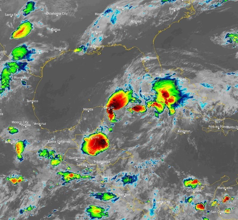
This system is expected to produce heavy rains over the eastern portions of the Yucatan Peninsula, the Cayman Islands and western Cuba through the rest of the day.
Heavy rains will begin to affect South Florida and the Keys beginning today and continuing through Saturday.
The following storm total rainfall amounts are currently expected:
- Eastern portions of the Yucatan Peninsula and the Cayman Islands: 50 – 100 mm (2 – 4 inches), with isolated maxima of 150 mm (6 inches).
- Western Cuba: 150 – 250 mm (6 to 10 inches), with isolated maxima of 355 mm (14 inches). This rain may cause life-threatening flash flooding and mudslides.
- South Florida including the Keys: 100 – 200 mm (4 – 8 inches) with maxima of 300 mm (12 inches). This rain may produce considerable flash and urban flooding.
Tropical storm conditions are expected to begin in the warning area in Florida tonight and early Saturday. Tropical storm conditions are possible in the watch area in Cuba today and are possible in the watch area in Florida and the northwestern Bahamas Saturday and Saturday night.
The combination of storm surge and the tide will cause normally dry areas near the coast to be flooded by rising waters moving inland from the shoreline.
The water could reach the following heights above ground somewhere in the indicated areas if the peak surge occurs at the time of high tide:
- Marco Island, FL to Card Sound Bridge: 30 – 90 cm (1 – 3 feet)
- Middle of Longboat Key, FL to Marco Island, FL: 30 – 60 cm (1 – 2 feet)
- Charlotte Harbor: 30 – 60 cm (1 – 2 feet)
- Florida Keys and Dry Tortugas: 30 – 60 cm (1 – 2 feet)
Surge-related flooding depends on the relative timing of the surge and the tidal cycle, and can vary greatly over short distances.
Isolated tornadoes are possible over South Florida beginning this evening and continuing through Saturday.
References:
1 Potential Tropical Cyclone One – Intermediate Advisory Number 2A – NWS National Hurricane Center Miami FL AL012022 – 100 AM CDT Fri Jun 03 2022
I'm a dedicated researcher, journalist, and editor at The Watchers. With over 20 years of experience in the media industry, I specialize in hard science news, focusing on extreme weather, seismic and volcanic activity, space weather, and astronomy, including near-Earth objects and planetary defense strategies. You can reach me at teo /at/ watchers.news.
Commenting rules and guidelines
We value the thoughts and opinions of our readers and welcome healthy discussions on our website. In order to maintain a respectful and positive community, we ask that all commenters follow these rules.