
Increased seismicity under Chiles-Cerro Negro volcanic complex, Colombia-Ecuador border
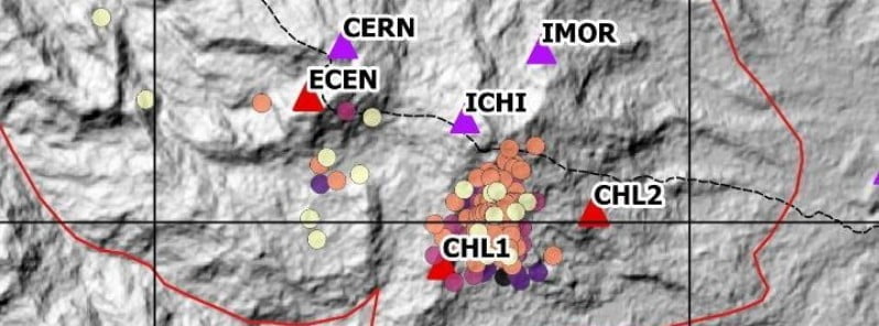
Image credit: IGEPN
IGEPN is reporting an increase in seismicity under the Chiles-Cerro Negro volcanic complex, located on the border of Ecuador and Colombia, 24 km (14.9 miles) W of the city of Tulcan and 130 km (80 miles) N of Quito. There are no confirmed historical records of eruptive activity for the Chiles and Cerro Negro volcanoes.
- There were several episodes of increased seismicity under this volcanic complex in recent years.
- The higher, glacier-covered summit of Chiles, about 4 km (2.5 miles) ESE of Cerro Negro, last erupted about 160 000 years ago.
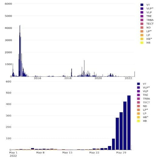
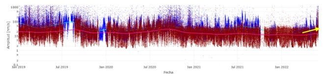
The upward trend in seismicity started on May 27, reaching almost 500 events on May 31.1
This seismicity is characterized by volcano-tectonic (VT) earthquakes, caused by the movement of magma beneath the surface of the Earth. This movement results in pressure changes where the rock around the magma has experienced stress. The stress can then cause the rock to break or move.
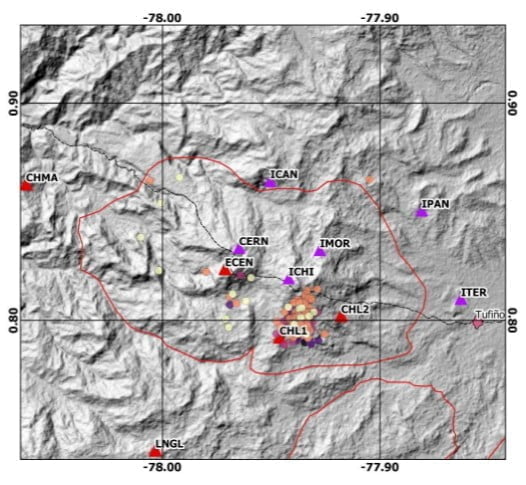
The events are concentrated on the southern flank of the Chiles volcano at depths between 0 and 2 km (1.2 miles) below sea level.
The strongest earthquake thus far was M2.5 registered at 17:09 LT on May 29. There are no reports that these events have been felt by the population living around the volcanic complex.
IGEPN added that this level of internal activity is moderate with an upward trend.
Geological summary
The Chiles-Cerro Negro volcanic complex includes both the Pleistocene Chiles and the Cerro Negro de Mayasquer stratovolcanoes astride the Colombia-Ecuador border.
Cerro Negro has a caldera open to the west, with andesitic and dacitic lava flows of possible Holocene age (Hall 1992, pers. comm.) and solfataras on the shore of a small crater lake.
An eruption reported in 1936 (VEI 2) may have been from Reventador.
The higher, glacier-covered summit of Chiles, about 4 km (2.5 miles) ESE of Cerro Negro, last erupted about 160 000 years ago, but it has a caldera open to the north with hot springs and an active hydrothermal system on its eastern flank.2
References:
1 INFORME ESPECIAL COMPLEJO VOLCÁNICO CHILES –CERRO NEGRO No.2022-001 – INCREMENTO DE LA ACTIVIDAD SÍSMICA – June 3, 2022
2 Chiles-Cerro Negro – Geological summary – GVP
I'm a dedicated researcher, journalist, and editor at The Watchers. With over 20 years of experience in the media industry, I specialize in hard science news, focusing on extreme weather, seismic and volcanic activity, space weather, and astronomy, including near-Earth objects and planetary defense strategies. You can reach me at teo /at/ watchers.news.
Commenting rules and guidelines
We value the thoughts and opinions of our readers and welcome healthy discussions on our website. In order to maintain a respectful and positive community, we ask that all commenters follow these rules.