
Florida State Guard activated as destructive tornadoes strike panhandle region
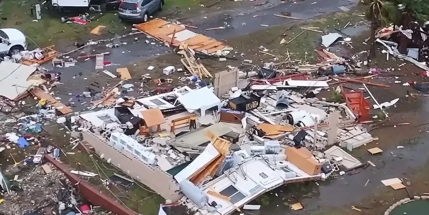
Image credit: Live Storms Media (stillshot)
The Florida panhandle was hit by at least three tornadoes on the morning of Tuesday, January 9, 2024, as reported by the National Weather Service (NWS), leading to widespread damage and prompting school closures across several counties.
A series of severe storms swept through the Florida panhandle on Tuesday morning, January 9, 2024, resulting in at least three reported tornadoes.
The National Weather Service (NWS) has been issuing continuous watches and warnings in response to the severe weather conditions. These storms, associated with a powerful low and an accompanying cold front, have caused significant damage in the region, including tilting homes and flattening RVs.
According to Ryan Truchelut, chief meteorologist at WeatherTiger, the severe weather impacts began Monday night and are expected to peak Tuesday morning in the Panhandle, continuing through Tuesday evening in the peninsula. The storm system is bringing a mix of potentially damaging winds, coastal flooding, tornadoes, and heavy rainfall.
In preparation for the severe weather, Florida Governor Ron DeSantis activated the Florida State Guard on Monday. This proactive measure, announced in a news release from the governor’s office, aims to address the anticipated adverse weather conditions across the state.
The NWS confirmed several tornadoes in the Panhandle on Tuesday morning, including near De Funiak Springs and Panama City, and another that crossed Interstate 10 near Marianna. While official confirmation of their strength and intensity is pending from the NWS, residents have taken to social media to share videos and pictures of the destruction left in the wake of these tornadoes.
“A very potent mid-upper level trough over the Central U.S. is becoming negatively tilted and this is allowing for rapid surface cyclogenesis over the Midwest and Ohio Valley on Tuesday,” NWS forecaster Hamrick noted. “The result will likely be a sub-980 mb surface low over Michigan by late Tuesday evening/night, and this low will continue lifting toward the northeast across southern Ontario and into Quebec by Wednesday afternoon.”
A strong cold front trailing south from the parent low will exit the East Coast overnight Tuesday, January 9 across the Mid-Atlantic and into early Wednesday morning (LT), January 10 for the Northeast U.S. Widespread hazardous weather impacts are expected for the eastern third of the U.S. in association with this low pressure system, and numerous warnings and advisories are now in effect from the local NWS forecast offices.
“One of the big things making weather headlines will be the widespread expanse of heavy rain capable of producing flooding from the Florida Panhandle all the way north to southern Maine,” Hamrick said.
In addition, high wind warnings are in effect for many areas near the coast and storm warnings for the open waters, and power outages are a real possibility.
“The strongest winds will be along the Atlantic coast and over the ridges of the Appalachians,” according to AccuWeather senior meteorologist Alex Sosnowski.
“Tree and property damage are likely. Large tree limbs may come crashing down on sidewalks, vehicles, homes and businesses without notice. Trash cans and other unsecured items in neighborhoods may become projectiles. Power outages could be long-lasting, especially in remote, heavily wooded areas.”
Severe thunderstorms are also expected from northern Florida to the coastal plain of the Carolinas, where a favorable combination of kinematics and instability will fuel intense storms capable of producing damaging winds and tornadoes.
A line of severe thunderstorms with embedded tornadoes continues to push east across the southeastern US as of 2pm EST today. If you're in a tornado warning, TAKE COVER NOW! Move to an interior room on the lowest floor of a sturdy building. Avoid windows. pic.twitter.com/kNLH1AcvSQ
— National Weather Service (@NWS) January 9, 2024
Conditions should slowly improve going into Wednesday in the wake of this intense storm system across the Eastern U.S., although it will still be rather breezy with west to northwesterly flow, and snow showers for the western Great Lakes and the eastern Ohio Valley.
Read more:
References:
1 Florida tornadoes: 3 twisters reported on panhandle as severe storm sweeps through state – USA Today – January 9, 2024
The Watchers team and our contributors bring the latest on extreme weather, earthquakes, volcanic eruptions, space weather, and all things science. We're all about making sense of the natural world and keeping you informed on what’s happening. Got a tip or a question? Hit us up using the form at newstips!
Commenting rules and guidelines
We value the thoughts and opinions of our readers and welcome healthy discussions on our website. In order to maintain a respectful and positive community, we ask that all commenters follow these rules.