
Dual atmospheric rivers forecast to bring heavy rainfall to Eastern and Midwest U.S.
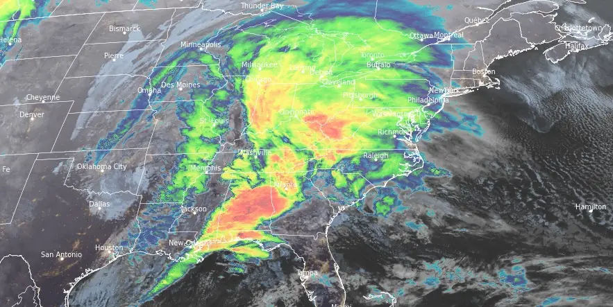
Image credit: NOAA/GOES-East, RAMMB/CIRA, The Watchers. Acquired at 08:30 UTC on January 9, 2024
The Eastern and Midwest regions of the United States are bracing for heavy precipitation this week, as two low pressure systems and associated atmospheric rivers (AR) pose significant flood risks and severe weather threats.
- Major storm system will hammer the Eastern U.S. with widespread heavy rain, strong winds, and severe thunderstorms on Tuesday into early Wednesday, January 9 – 10, 2024.
- Widespread hazardous weather impacts are expected and numerous warnings and advisories are now in effect from the local NWS forecast offices.
- Severe thunderstorms are expected from northern Florida to the coastal plain of the Carolinas, where a favorable combination of kinematics and instability will fuel intense storms capable of producing damaging winds and tornadoes.
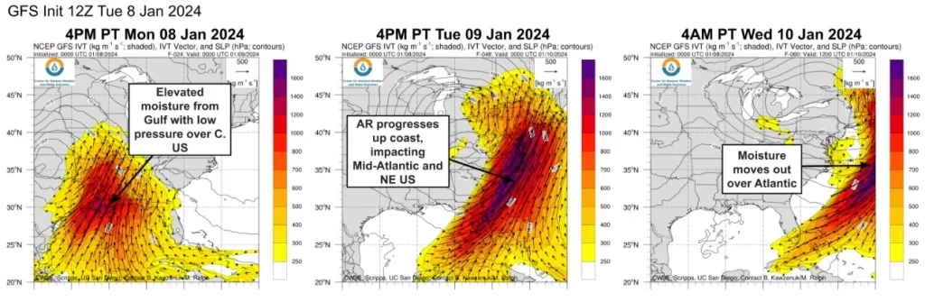
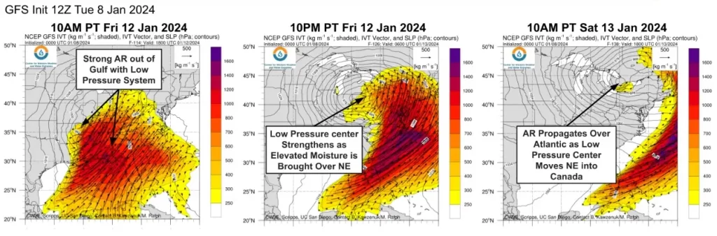
The Center for Western Weather and Water Extremes (CW3E) reported on January 8, 2024, that two potent low pressure systems, each associated with an atmospheric river, are forecast to impact the Eastern and Midwest regions of the United States. The first strong atmospheric river, with an Integrated Water Vapor Transport (IVT) exceeding 1 200 kg m-1 s-1 in the core, developed early on Monday, January 8, and is expected to progress up the US East Coast through Wednesday, January 10, before moving out to the Atlantic.
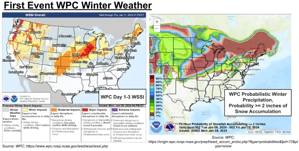
This system is predicted to deliver a mix of heavy rain and snow to the Eastern US. Given the recent atmospheric river that impacted the region, there is an increased threat of flooding. The Weather Prediction Center (WPC) has forecast a Moderate Risk (40% chance) of flooding in select areas through Tuesday night.
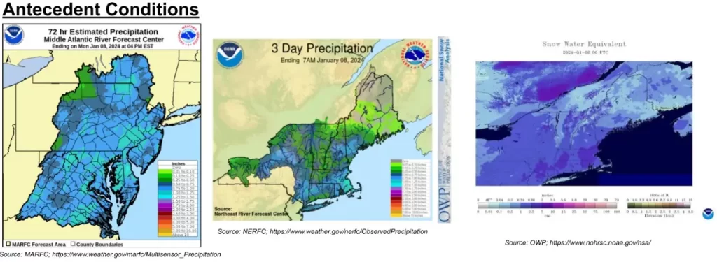
The first event’s association with a stronger atmospheric river and low pressure system brings significant moisture, leading to heavy precipitation across the Eastern US. This follows a previous event on Saturday, January 6, which brought widespread precipitation and snowfall to the East Coast. The forecasted heavy rainfall, combined with previous conditions, poses a substantial flooding threat, particularly in areas that received over 25 mm (1 inch) of rain and in the Northeast, where rain-on-snow flooding is a concern.
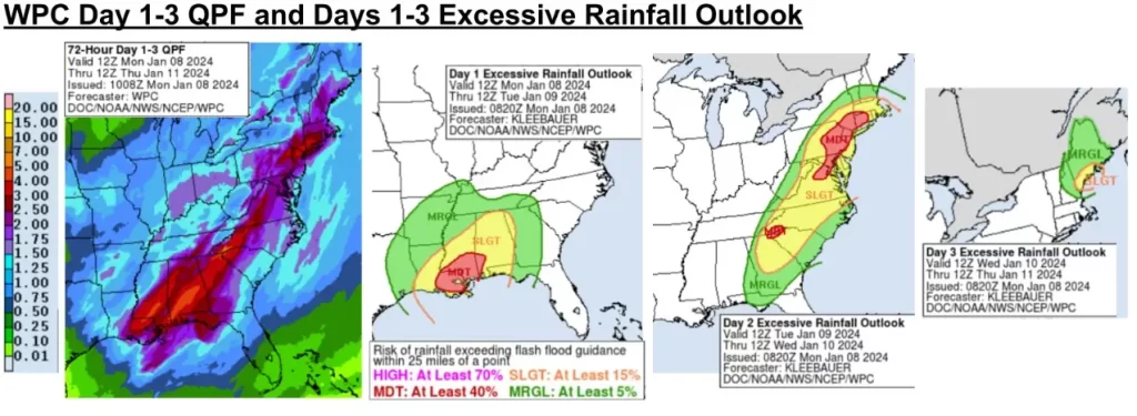
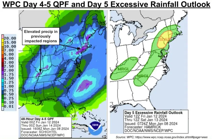
Precipitation is expected to exceed 38 mm (1.5 inches) across much of the Eastern Seaboard, with the highest totals above 76 mm (3 inches) forecast for the Southeastern US and New York City Metro regions. The WPC ERO indicates a Moderate Risk for rainfall exceeding flash flood guidance in southern Louisiana and Mississippi on Day 1, and in the Charlotte Metro, Mid-Atlantic, and NYC Metro regions on Day 2.
The WPC’s Winter Storm Severity Index indicates Moderate Impacts expected in the Midwest and northern New England. Probabilistic winter precipitation forecasts suggest high chances of snowfall accumulations ≥ 51 mm (2 inches) in regions expected to receive moderate winter storm impacts.
“A very potent mid-upper level trough over the Central U.S. is becoming negatively tilted and this is allowing for rapid surface cyclogenesis over the Midwest and Ohio Valley on Tuesday,” NWS forecaster Hamrick noted. “The result will likely be a sub-980 mb surface low over Michigan by late Tuesday evening/night, and this low will continue lifting toward the northeast across southern Ontario and into Quebec by Wednesday afternoon.”
A strong cold front trailing south from the parent low will exit the East Coast overnight Tuesday, January 9 across the Mid-Atlantic and into early Wednesday morning (LT), January 10 for the Northeast U.S. Widespread hazardous weather impacts are expected for the eastern third of the U.S. in association with this low pressure system, and numerous warnings and advisories are now in effect from the local NWS forecast offices.
“One of the big things making weather headlines will be the widespread expanse of heavy rain capable of producing flooding from the Florida Panhandle all the way north to southern Maine,” Hamrick said.
In addition, high wind warnings are in effect for many areas near the coast and storm warnings for the open waters, and power outages are a real possibility.
“The strongest winds will be along the Atlantic coast and over the ridges of the Appalachians,” according to AccuWeather senior meteorologist Alex Sosnowski.
“Tree and property damage are likely. Large tree limbs may come crashing down on sidewalks, vehicles, homes and businesses without notice. Trash cans and other unsecured items in neighborhoods may become projectiles. Power outages could be long-lasting, especially in remote, heavily wooded areas.”
Severe thunderstorms are also expected from northern Florida to the coastal plain of the Carolinas, where a favorable combination of kinematics and instability will fuel intense storms capable of producing damaging winds and tornadoes.
Conditions should slowly improve going into Wednesday in the wake of this intense storm system across the Eastern U.S., although it will still be rather breezy with west to northwesterly flow, and snow showers for the western Great Lakes and the eastern Ohio Valley.
Subsequently, the second atmospheric river is set to form in the Gulf on Thursday, January 11, moving through the East Coast and over the Atlantic by Friday, January 12. The WPC anticipates an additional rainfall of more than 25 mm (1 inch) as this system progresses along the coast, maintaining the flood risk throughout the region.
Precipitation during this event is forecast to exceed 38 mm (1.5 inches) in the Midwest, New England, northeastern Pennsylvania, and northern New Jersey. The WPC ERO indicates a Slight Risk (15% chance) of rainfall exceeding flash flood guidance in parts of the Northeast.
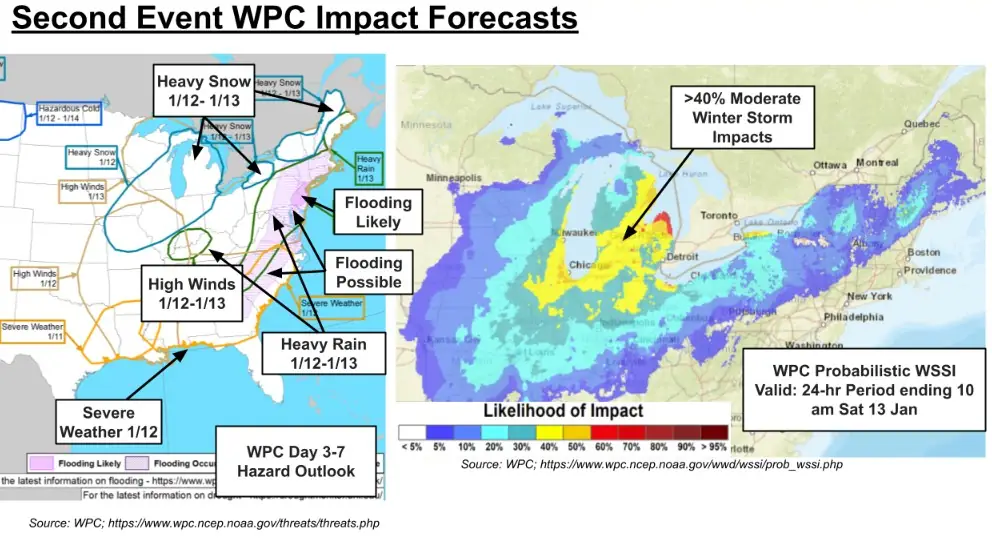
WPC’s Day 3-7 Hazards Outlook highlights moderate risks of severe weather along the Gulf and Southeast US Coasts; heavy snow in the Midwest, Great Lakes, and northern New England; heavy rain in the Mid-Atlantic, New England Coast, and Midwest; high winds throughout the Eastern US, and likely flooding in the Delaware River Basin. Probabilistic WSSI forecasts over a 40% chance of moderate impacts in Michigan and along the Great Lakes coast.
For the Western U.S., the weather pattern will also be active with a strong Pacific front moving inland with very heavy snow for the Cascades and then across the Northern Rockies with snow levels dropping over time, Hamrick said. By Wednesday night, a second disturbance moves inland across the Desert Southwest and this brings valley rain and mountain snow across Arizona and New Mexico.
Meanwhile, an arctic front drops southward from Canada on Wednesday and this will herald the arrival of the coldest temperatures so far this season for the Northern Plains, with subzero lows becoming a reality for Montana and North Dakota, and this cold airmass will continue settling southward through the end of the week.
References:
1 CW3E AR Update: 8 January 2024 East Coast Outlook
2 Short Range Forecast Discussion – NWS Weather Prediction Center College Park MD – 247 AM EST Tue Jan 9 2024
The Watchers team and our contributors bring the latest on extreme weather, earthquakes, volcanic eruptions, space weather, and all things science. We're all about making sense of the natural world and keeping you informed on what’s happening. Got a tip or a question? Hit us up using the form at newstips!
Commenting rules and guidelines
We value the thoughts and opinions of our readers and welcome healthy discussions on our website. In order to maintain a respectful and positive community, we ask that all commenters follow these rules.