NWS confirms tornado near Federal Highway in Fort Lauderdale, Florida

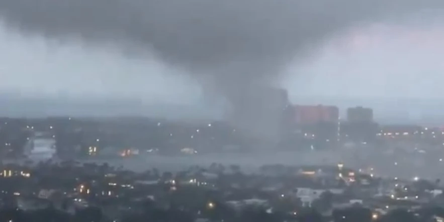
A tornado swept through Fort Lauderdale, Florida, on Saturday, January 6, 2024, causing damage to boats and downing power lines, with the National Weather Service (NWS) confirming reports of the twister near Federal Highway around 17:50 local time. NWS is expected to conduct a damage survey on Sunday to determine the strength and path of the tornado.
Fort Lauderdale, Florida, experienced a rare tornado event on Saturday, leaving a trail of disruption in its wake. The tornado, confirmed by the National Weather Service office in Miami, rolled through the area near Federal Highway at approximately 17:50 local time, following a Tornado Warning issued just five minutes prior.
The city officials took to Facebook to announce that, fortunately, no injuries have been reported and the damage from the storm appears to be minor.
Tornado just east of downtown Ft Lauderdale this afternoon. Was watching the signature on the radar and it looked like it would be close.
— Craig Setzer, CCM (@CraigSetzer) January 6, 2024
Boy was it. From what I could tell, @NWSMiami issued the warning just in time. pic.twitter.com/k74EbBqwTg
The sudden and violent weather caught many by surprise, including a couple from New York who were in South Florida to support the Buffalo Bills.
They received a Tornado Warning alert on their cellphones moments before witnessing the tornado’s path through a residential area and a marina, capturing the entire event on video. Meghan Collins, one of the witnesses, humorously noted to FOX Weather, “We were feeling very pleased with ourselves for missing the snow. Then we got more than we bargained for,” reflecting on the unexpected turn from vacation weather to severe storm conditions.
The tornado in Fort Lauderdale was part of a larger severe weather pattern affecting the Sunshine State that day, which included reports of funnel clouds, a waterspout, and damaging wind gusts. The most substantial thunderstorm wind gust reported was 85 km/h (52 mph) near Pine Island.
These storms were associated with a trailing cold front linked to a powerful nor’easter moving up the East Coast, which is wreaking havoc with a mix of ice, snow, and rain through the mid-Atlantic and Northeast.
With more severe weather possible in Florida in the coming days as another powerful storm moves across the eastern half of the country, residents and visitors are urged to stay vigilant and prepared.
As the U.S. braces for a series of storm systems, residents across several regions should prepare for a range of severe weather conditions.
The first of these systems is a major winter storm currently impacting the Northeast and Central Appalachians. Additional snowfall of 10 – 20 cm (4 – 8 inches) is expected across these areas through tonight, with the storm anticipated to move away into the Atlantic afterward. Residents are urged to heed Winter Storm Warnings and Winter Weather Advisories in effect, with conditions expected to improve by Monday, January 8.
The Rockies are presently facing the second storm system, which is bringing heavy snow across the Intermountain West and Central/Southern Rockies, with lesser extents in the Northern Rockies. This system will evolve into a deep and dynamic mid-latitude cyclone over the Southern Plains by Monday, leading to heavy snow and strong winds across the Plains and Midwest through Tuesday.
Some areas in the Midwest might see local snow accumulations up to 30 cm (12 inches). Particularly in the Central Plains, blizzard conditions are anticipated due to wind gusts in excess of 80 km/h (50 mph), causing near-zero visibility and perilous travel conditions. Winter Storm Watches are in place for parts of the Southern High Plains, Central Plains, and Middle Mississippi Valley, indicating the wide-reaching impact of this system.
Alongside these snow events, the central Gulf Coast through much of the Eastern U.S. is likely to face significant river and flash flooding early this week. Potent onshore winds will cause extensive coastal flooding along the eastern Gulf Coast and much of the East Coast, with particularly significant flooding expected in the Carolinas and Mid-Atlantic.
Areas of the Gulf Coast are under a Slight Risk of Excessive Rainfall, which could lead to Flash Flooding, with storms supporting 38 – 64 mm (1.5 – 2.5 inches) per hour rain rates and localized totals of 100 – 150 mm (4 – 6 inches) possible. Moreover, there is a Slight Risk of Severe Thunderstorms across parts of southeast Texas, southern Louisiana, southern Mississippi, southern Alabama, and into the western Florida panhandle by late Monday night, with damaging wind gusts and tornadoes possible. Widespread wind gusts in excess of 80 km/h (50 mph) are expected in the eastern Gulf Coast, and residents should prepare for potential power outages.
The third system, arriving over the Pacific Northwest tonight, is a deep Pacific storm set to bring heavy coastal rain, mountain snow, and strong winds across the region. This significant winter storm is expected to deliver several feet of snow to the Washington and Oregon Cascades, peaking Tuesday and Wednesday.
References:
1 Tornado rips through Fort Lauderdale as storms march across Florida – FOX Weather – January 6, 2024
2 Short Range Forecast Discussion – vNWS Weather Prediction Center College Park MD – 252 AM EST Sun Jan 07 2024
Featured image credit: Craig Setzer, CCM (stillshot)


Commenting rules and guidelines
We value the thoughts and opinions of our readers and welcome healthy discussions on our website. In order to maintain a respectful and positive community, we ask that all commenters follow these rules.