
Icing expected in the Appalachians, heavy snow across the interior Mid-Atlantic and Northeast, U.S.
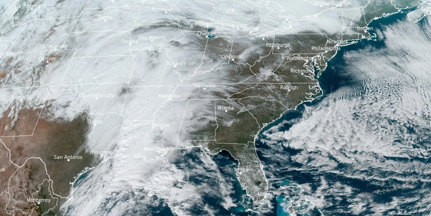
Image credit: NOAA/GOES-East, RAMMB/CIRA, The Watchers. Acquired at 18:30 UTC on January 5, 2024
A significant winter storm is set to bring ice and snow from the Southern Appalachians through New England this weekend, with travel disruptions, power outages, and coastal flooding anticipated due to heavy snow, gusty winds, and ice accumulations.
A significant winter storm is developing as the night approaches, threatening areas from Southern Appalachians all the way to New England with ice and snow. The storm is expected to cause significant travel disruptions throughout the weekend, with key areas facing hazardous conditions.
In the Southern Appalachians, ice accumulations exceeding 2.5 mm (0.1 inches) are likely (70 – 90%), with potential for higher local accumulations. This icing, coupled with sleet, is expected to produce hazardous travel conditions, particularly on Friday night and Saturday, January 5 and 6, 2024. For residents and travelers in these regions, it’s crucial to stay updated and prepared for rapidly changing road conditions.
The interior Mid-Atlantic and New England are bracing for heavy snow from Saturday afternoon through Sunday, January 6 to 7. While there is some uncertainty about the exact rain-snow transition zones, there is a high chance (50-90%) of areas exceeding 20 cm (8 inches) of snow, particularly from the Poconos eastward through much of southern New England.
Higher elevations may even see more than 30 cm (12 inches) of snow, making travel difficult and potentially dangerous. The combination of heavy, wet snow and gusty winds is expected to stretch from northeast Pennsylvania through much of southern and central New England, leading to difficult travel conditions, as well as possible power outages and tree damage due to the weight of the snow and wind force.
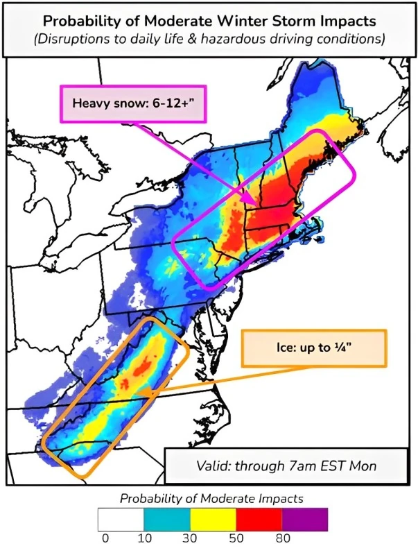
Along the Mid-Atlantic and southern New England coasts, gusty onshore winds might lead to minor flooding, especially during the Sunday morning high tide cycle. Residents in these coastal areas should be aware of the flood risk and take necessary precautions.
An upper trough moving through the Plains and Mississippi Valley is behind the development of this dynamic storm system. This storm is expected to bring light to moderate snow across portions of Kansas, Oklahoma, and Missouri, while also generating showers and thunderstorms over the western/central Gulf Coast.
Additional snow showers are predicted across portions of the Northern Plains and Upper Midwest, phasing with the developing Nor’easter and further impacting the interior Mid-Atlantic and New England with heavy snow.
As this system moves eastward, another East Pacific system is anticipated to enter the West tonight, bringing with it heavy mountain snow to the western mountains and coastal rain to the Northwest coast through Sunday. The Cascades and Sierra are expected to receive around 30 cm (1 foot) of snow, with slightly lesser totals for the highest peaks of the Intermountain West.
References:
1 Key Messages for January 6 – 7, 2024 East Coast Winter Storm – NWS/WPC – January 5, 2024
2 Short Range Forecast Discussion – NWS Weather Prediction Center College Park MD – 258 AM EST Fri Jan 05 2024
The Watchers team and our contributors bring the latest on extreme weather, earthquakes, volcanic eruptions, space weather, and all things science. We're all about making sense of the natural world and keeping you informed on what’s happening. Got a tip or a question? Hit us up using the form at newstips!
Commenting rules and guidelines
We value the thoughts and opinions of our readers and welcome healthy discussions on our website. In order to maintain a respectful and positive community, we ask that all commenters follow these rules.