
Mount Mayon volcano status lowered to Alert Level 3, Philippines
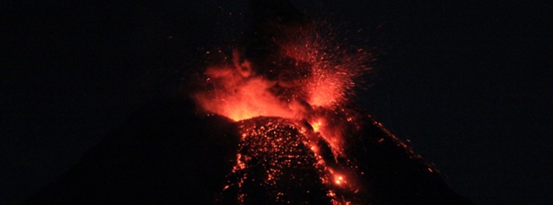
Featured image: Lava fountaining and lava flow at Mayon summit crater - February 25, 2018. Credit: PHIVOLCS
The Philippine Institute of Volcanology and Seismology (PHIVOLCS) lowered Mayon Volcano's status from Alert Level 4 (hazardous eruption imminent) to Alert Level 3 (decreased tendency towards hazardous eruption) on March 6, 2018.
The volcano's condition in the past week has been characterized by a general decline in unrest reflected by moderate seismicity and degassing, deflation of the edifice and a decrease in eruptive activity at the summit crater, the agency said.
These observations are supported by the following monitoring parameters:
- Activity has diminished to sporadic degassing with associated ash plumes, weak lava fountaining, quiet lava flow and lava collapse, interspersed with two to four days of relative quiescence. The decline in the intensity and frequency of events suggests a gradual depletion of eruptible magma at the shallow levels of the edifice.
- Seismic activity has been dominated by low frequency events associated with degassing at the summit and signals of rockfall and small-volume pyroclastic density currents or PDCs generated by the collapsing front and margins of lava flows on the Miisi, Bonga and Basud Gullies and intermediary channels. This is reflected in the diminishing overall seismic energy release from the volcano despite the infrequent occurrence of effusive activity at the summit crater. In the past 24 hours, a total of only 4 volcanic earthquakes and 44 rockfall events were recorded by the seismic monitoring network.
- Ground deformation data from Precise Leveling (PL) surveys and real-time electronic tilt continue to record deflation of the lower slopes that began on February 20, 2018. The downtrend in ground deformation follows a period of continuous inflation that began in October-November 2017 and indicates a decrease in magma recharge from deep to shallow levels of the edifice. However, based on medium-term PL data, the volcano is still inflated relative to January 2010 baselines.
- Measured magmatic sulfur dioxide or SO2 flux throughout the eruption has varied from a maximum of 4 270 tonnes/day on February 21 to 1 400 tonnes/day on March 3. These concentrations are significantly lower than those measured for past eruptions (e.g. up to >8 000 tonnes/day in 2009) and are consistent with batches of partially degassed magma that have incrementally risen to shallow depths within the edifice. SO2 emission was measured at an average of 2 560 tonnes/day yesterday, March 5, 2018.
"In view of the above observations, PHIVOLCS-DOST is lowering the alert status of Mayon from Alert Level 4 to Alert Level 3 to reflect the overall decrease in the level of unrest," the agency said.
"Alert Level 3 means that there is a decreased tendency towards hazardous explosive eruption BUT should not be interpreted that unrest has ceased. The volcano can be expected to continue generating volcanic earthquakes, magmatic gas output and weak surface processes such as sporadic degassing and lava effusion events, steam-driven explosions, rockfall and PDCs, while shallow remnant magma rests within the edifice," it added.
There are still 2 665 families or 10 933 persons in evacuation centers as of March 6, 2018.
Should the potential for hazardous explosive eruption be forewarned by an uptrend or pronounced change in monitoring parameters, the Alert Level may be raised back to Alert Level 4.
Conversely, should there be a persistent downtrend in monitoring parameters, then the Alert Level will be further lowered to Alert Level 2.
PHIVOLCS-DOST reminds the public that sudden explosions, lava collapses, PDCs and ashfall can still occur at Alert Level 3 and threaten areas in the upper to middle slopes of Mayon.
The agency recommends that entry into the 6 km-radius (3.7 miles) Permanent Danger Zone or PDZ and a precautionary 7 km-radius (4.3 miles) Extended Danger Zone or EDZ in the south-southwest to east-northeast sector, stretching from Anoling, Camalig to Sta. Misericordia, Sto. Domingo, must be strictly prohibited.
People residing close to these danger areas are also advised to observe precautions associated with rockfalls, PDCs and ashfall.
Active river channels and those perennially identified as lahar prone areas in the southern and eastern sectors should also be avoided especially during bad weather conditions or when there is heavy and prolonged rainfall.
I'm a dedicated researcher, journalist, and editor at The Watchers. With over 20 years of experience in the media industry, I specialize in hard science news, focusing on extreme weather, seismic and volcanic activity, space weather, and astronomy, including near-Earth objects and planetary defense strategies. You can reach me at teo /at/ watchers.news.
Commenting rules and guidelines
We value the thoughts and opinions of our readers and welcome healthy discussions on our website. In order to maintain a respectful and positive community, we ask that all commenters follow these rules.