
Strong and shallow M6.7 aftershock hits Papua New Guinea
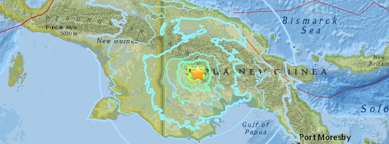
Image credit: USGS
A strong and shallow earthquake registered by the USGS as M6.7 hit Papua New Guinea at 14:13 UTC on March 6, 2018. The agency is reporting a depth of 22.9 km (14.2 miles). Geoscience Australia is reporting M6.8 at a depth of 0 km. This is the strongest aftershock to hit the region since the massive M7.5 earthquake on February 25, 2018.
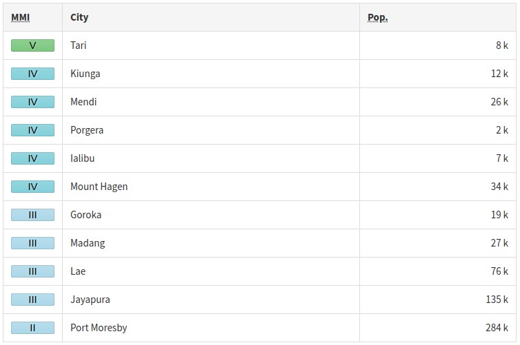
According to the USGS, the epicenter of today's M6.7 was located 56.5 km (35.1 miles) SW of Tari (population 8 186), 116.8 km (72.6 miles) W of Mendi (population 26 252), and 147.4 km (91.6 miles) E of Kiunga (population 11 536).
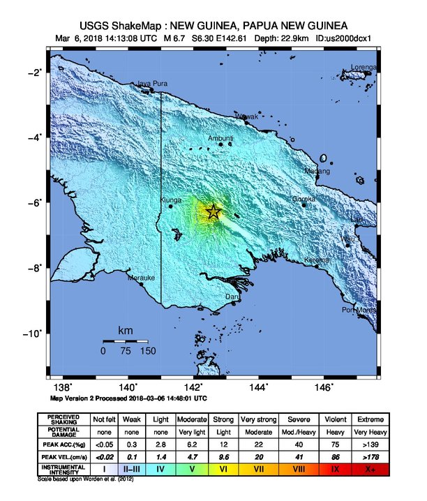
The USGS issued a green alert for shaking-related fatalities and economic losses. There is a low likelihood of casualties and damage.
Overall, the population in this region resides in structures that are vulnerable to earthquake shaking, though resistant structures exist. The predominant vulnerable building types are unreinforced brick with concrete floor and precast concrete frame with wall construction.
Recent earthquakes in this area have caused secondary hazards such as landslides that might have contributed to losses.
Update
At least 18 people have been killed by this aftershock, William Bando, Hela Province administrator said Wednesday.
"I have just received reports that 18 people were killed last night," he told Reuters. "It appears Hides was hardest hit. We haven't heard about potential casualties there yet, but it is a big village with many people."
Estimated population exposure to earthquake shaking
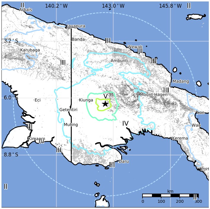
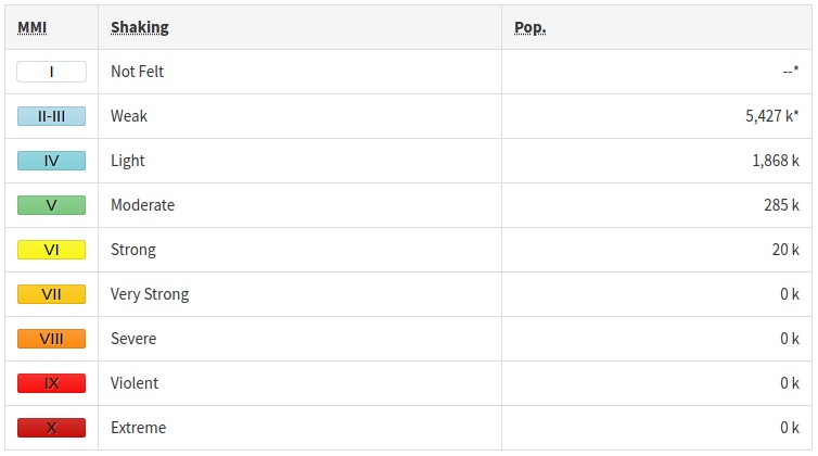
Selected cities exposed
Regional seismicity
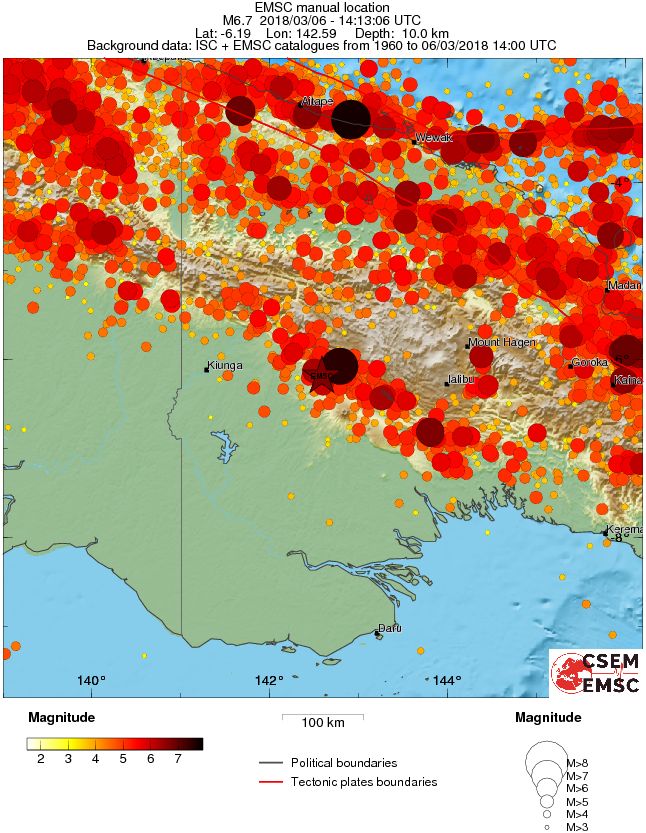
This region was hit by 122 M4+ earthquakes since February 25, 2018, including M7.5 mainshock.
It's still unclear how many people died in the M7.5 earthquake due to severely disrupted transport and telecommunications, but PNG's Red Cross said it believes the number has reached 80.
However, unofficial reports received on Saturday, March 3, mention at least 156 deaths and at least 10 villages covered in debris after massive landslides.
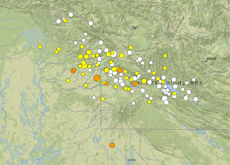
Image credit: USGS
- 5.1
91km W of Mendi, Papua New Guinea
2018-03-06 14:50:54 (UTC)
- 5.0
129km SW of Mendi, Papua New Guinea
2018-03-06 14:40:01 (UTC)
- 6.7
112km SW of Porgera, Papua New Guinea
2018-03-06 14:13:08 (UTC)
- 4.8
106km W of Mendi, Papua New Guinea
2018-03-06 12:01:25 (UTC)
- 4.7
122km E of Kiunga, Papua New Guinea
2018-03-06 10:03:56 (UTC)
- 5.3
121km E of Kiunga, Papua New Guinea
2018-03-06 03:26:49 (UTC)
- 5.0
76km WSW of Mendi, Papua New Guinea
2018-03-06 02:52:31 (UTC)
- 4.2
103km WSW of Porgera, Papua New Guinea
2018-03-05 12:35:07 (UTC)
- 4.7
71km WSW of Mendi, Papua New Guinea
2018-03-05 11:47:15 (UTC)
- 4.1
112km ENE of Lake Murray, Papua New Guinea
2018-03-05 00:27:46 (UTC)
- 4.2
75km WSW of Mendi, Papua New Guinea
2018-03-04 22:38:01 (UTC)
- 4.9
114km WSW of Mendi, Papua New Guinea
2018-03-04 20:24:03 (UTC)
- 6.0
112km SW of Porgera, Papua New Guinea
2018-03-04 19:56:18 (UTC)
- 5.8
85km SW of Porgera, Papua New Guinea
2018-03-04 14:33:21 (UTC)
- 5.4
100km SSW of Porgera, Papua New Guinea
2018-03-04 12:40:01 (UTC)
- 5.1
67km WSW of Mendi, Papua New Guinea
2018-03-04 11:44:24 (UTC)
- 4.9
44km SW of Mendi, Papua New Guinea
2018-03-03 23:01:00 (UTC)
- 4.4
44km WNW of Mendi, Papua New Guinea
2018-03-03 17:15:06 (UTC)
- 4.9
108km SW of Porgera, Papua New Guinea
2018-03-03 16:29:14 (UTC)
- 4.7
85km W of Mendi, Papua New Guinea
2018-03-03 15:49:13 (UTC)
- 4.8
87km WSW of Mendi, Papua New Guinea
2018-03-03 06:26:33 (UTC)
- 4.8
80km W of Mendi, Papua New Guinea
2018-03-02 22:38:49 (UTC)
- 5.1
95km SSW of Porgera, Papua New Guinea
2018-03-02 21:30:58 (UTC)
- 4.5
93km W of Mendi, Papua New Guinea
2018-03-02 18:42:29 (UTC)
- 4.6
48km WSW of Mendi, Papua New Guinea
2018-03-02 18:27:11 (UTC)
- 4.6
101km SW of Porgera, Papua New Guinea
2018-03-02 12:44:20 (UTC)
- 5.1
103km SW of Porgera, Papua New Guinea
2018-03-02 07:59:02 (UTC)
- 4.9
118km SW of Porgera, Papua New Guinea
2018-03-02 03:14:37 (UTC)
- 5.6
98km SW of Porgera, Papua New Guinea
2018-03-02 03:01:23 (UTC)
- 5.0
100km SSW of Porgera, Papua New Guinea
2018-03-02 00:57:12 (UTC)
- 4.6
84km W of Mendi, Papua New Guinea
2018-03-01 08:17:40 (UTC)
- 4.5
85km WSW of Mendi, Papua New Guinea
2018-03-01 03:46:58 (UTC)
- 4.6
97km SW of Porgera, Papua New Guinea
2018-03-01 00:22:11 (UTC)
- 4.5
43km W of Mendi, Papua New Guinea
2018-02-28 22:28:32 (UTC)
- 4.7
90km SSW of Porgera, Papua New Guinea
2018-02-28 19:00:18 (UTC)
- 4.6
98km WSW of Mendi, Papua New Guinea
2018-02-28 18:03:46 (UTC)
- 4.8
81km SW of Porgera, Papua New Guinea
2018-02-28 14:45:21 (UTC)
- 4.2
108km W of Mendi, Papua New Guinea
2018-02-28 14:30:36 (UTC)
- 5.0
108km SW of Porgera, Papua New Guinea
2018-02-28 14:00:56 (UTC)
- 4.3
55km W of Mendi, Papua New Guinea
2018-02-28 13:08:46 (UTC)
- 4.3
126km SW of Porgera, Papua New Guinea
2018-02-28 12:52:40 (UTC)
- 4.3
87km E of Kiunga, Papua New Guinea
2018-02-28 12:17:17 (UTC)
- 4.4
103km E of Kiunga, Papua New Guinea
2018-02-28 12:00:03 (UTC)
- 4.8
100km SW of Porgera, Papua New Guinea
2018-02-28 11:35:16 (UTC)
- 4.3
106km E of Kiunga, Papua New Guinea
2018-02-28 10:02:56 (UTC)
- 5.2
110km SW of Porgera, Papua New Guinea
2018-02-28 05:22:12 (UTC)
- 4.8
103km SW of Porgera, Papua New Guinea
2018-02-28 04:14:31 (UTC)
- 4.9
114km SW of Porgera, Papua New Guinea
2018-02-28 03:30:37 (UTC)
- 6.1
111km SW of Porgera, Papua New Guinea
2018-02-28 02:45:45 (UTC)
- 4.7
52km WSW of Mendi, Papua New Guinea
2018-02-28 00:18:51 (UTC)
- 4.9
73km W of Mendi, Papua New Guinea
2018-02-27 23:59:53 (UTC)
- 4.3
67km SSW of Porgera, Papua New Guinea
2018-02-27 21:17:47 (UTC)
- 5.2
91km W of Mendi, Papua New Guinea
2018-02-27 20:11:04 (UTC)
- 4.5
94km SW of Porgera, Papua New Guinea
2018-02-27 18:30:54 (UTC)
- 5.2
78km SSW of Porgera, Papua New Guinea
2018-02-27 16:19:53 (UTC)
- 4.5
48km WSW of Mendi, Papua New Guinea
2018-02-27 15:27:07 (UTC)
- 5.0
76km WSW of Mendi, Papua New Guinea
2018-02-27 14:11:18 (UTC)
- 5.0
54km WSW of Mendi, Papua New Guinea
2018-02-27 13:58:27 (UTC)
- 4.6
101km W of Mendi, Papua New Guinea
2018-02-27 13:28:47 (UTC)
- 4.5
71km W of Mendi, Papua New Guinea
2018-02-27 12:49:10 (UTC)
- 4.4
86km WSW of Mendi, Papua New Guinea
2018-02-27 11:19:45 (UTC)
- 4.9
20km SW of Mendi, Papua New Guinea
2018-02-27 10:49:55 (UTC)
- 4.9
51km WSW of Mendi, Papua New Guinea
2018-02-27 10:33:45 (UTC)
- 5.2
96km W of Mendi, Papua New Guinea
2018-02-27 07:19:23 (UTC)
- 5.6
71km WSW of Mendi, Papua New Guinea
2018-02-27 06:19:12 (UTC)
- 4.8
70km WSW of Mendi, Papua New Guinea
2018-02-27 05:51:26 (UTC)
- 4.9
104km WSW of Porgera, Papua New Guinea
2018-02-27 05:35:37 (UTC)
- 5.2
57km SW of Mendi, Papua New Guinea
2018-02-27 02:15:07 (UTC)
- 5.0
89km SW of Porgera, Papua New Guinea
2018-02-27 00:55:22 (UTC)
- 5.1
46km SW of Mendi, Papua New Guinea
2018-02-27 00:08:13 (UTC)
- 4.5
60km W of Mendi, Papua New Guinea
2018-02-27 00:05:14 (UTC)
- 4.8
103km WSW of Porgera, Papua New Guinea
2018-02-26 22:16:56 (UTC)
- 4.7
110km SW of Porgera, Papua New Guinea
2018-02-26 22:02:30 (UTC)
- 5.0
90km WSW of Mendi, Papua New Guinea
2018-02-26 21:52:36 (UTC)
- 5.1
40km SSW of Mendi, Papua New Guinea
2018-02-26 19:21:51 (UTC)
- 5.4
83km SW of Porgera, Papua New Guinea
2018-02-26 18:28:03 (UTC)
- 4.5
94km WSW of Porgera, Papua New Guinea
2018-02-26 17:58:05 (UTC)
- 5.2
79km WSW of Porgera, Papua New Guinea
2018-02-26 17:41:15 (UTC)
- 6.2
56km SW of Mendi, Papua New Guinea
2018-02-26 15:17:59 (UTC)
- 4.1
51km WSW of Mendi, Papua New Guinea
2018-02-26 13:18:48 (UTC)
- 4.8
57km WSW of Mendi, Papua New Guinea
2018-02-26 12:49:45 (UTC)
- 5.2
37km WSW of Mendi, Papua New Guinea
2018-02-26 12:34:54 (UTC)
- 5.0
46km WSW of Mendi, Papua New Guinea
2018-02-26 12:29:30 (UTC)
- 5.7
37km SSW of Mendi, Papua New Guinea
2018-02-26 11:56:07 (UTC)
- 4.7
66km W of Mendi, Papua New Guinea
2018-02-26 11:04:12 (UTC)
- 4.9
48km WSW of Mendi, Papua New Guinea
2018-02-26 11:00:17 (UTC)
- 4.7
38km SSW of Mendi, Papua New Guinea
2018-02-26 10:20:01 (UTC)
- 4.8
90km W of Mendi, Papua New Guinea
2018-02-26 10:07:48 (UTC)
- 4.9
82km WSW of Mendi, Papua New Guinea
2018-02-26 09:28:18 (UTC)
- 5.0
91km W of Mendi, Papua New Guinea
2018-02-26 09:19:43 (UTC)
- 6.0
50km WSW of Mendi, Papua New Guinea
2018-02-26 08:26:59 (UTC)
- 4.6
91km W of Mendi, Papua New Guinea
2018-02-26 07:41:04 (UTC)
- 4.5
12km W of Porgera, Papua New Guinea
2018-02-26 07:26:31 (UTC)
- 5.1
95km SW of Porgera, Papua New Guinea
2018-02-26 07:01:49 (UTC)
- 4.6
99km SW of Porgera, Papua New Guinea
2018-02-26 06:27:50 (UTC)
- 5.0
96km W of Mendi, Papua New Guinea
2018-02-26 05:28:01 (UTC)
- 4.8
123km WSW of Mendi, Papua New Guinea
2018-02-26 05:20:13 (UTC)
- 4.7
27km SW of Mendi, Papua New Guinea
2018-02-26 04:54:00 (UTC)
- 4.8
72km W of Mendi, Papua New Guinea
2018-02-26 04:37:07 (UTC)
- 5.2
70km W of Mendi, Papua New Guinea
2018-02-26 03:12:57 (UTC)
- 5.0
76km W of Mendi, Papua New Guinea
2018-02-26 03:10:59 (UTC)
- 4.8
49km SW of Mendi, Papua New Guinea
2018-02-26 02:31:52 (UTC)
- 5.0
78km W of Mendi, Papua New Guinea
2018-02-26 02:25:34 (UTC)
- 4.1
52km WSW of Mendi, Papua New Guinea
2018-02-26 01:31:40 (UTC)
- 4.6
76km W of Mendi, Papua New Guinea
2018-02-26 00:16:43 (UTC)
- 4.7
67km WSW of Mendi, Papua New Guinea
2018-02-25 23:46:22 (UTC)
- 4.6
57km W of Mendi, Papua New Guinea
2018-02-25 23:07:27 (UTC)
- 5.0
62km WSW of Mendi, Papua New Guinea
2018-02-25 22:57:46 (UTC)
- 5.0
91km SSW of Porgera, Papua New Guinea
2018-02-25 22:28:13 (UTC)
- 5.0
52km WSW of Mendi, Papua New Guinea
2018-02-25 22:19:11 (UTC)
- 4.5
72km W of Mendi, Papua New Guinea
2018-02-25 22:09:37 (UTC)
- 5.2
82km SW of Porgera, Papua New Guinea
2018-02-25 21:47:46 (UTC)
- 5.0
96km WSW of Porgera, Papua New Guinea
2018-02-25 21:11:43 (UTC)
- 4.9
89km WSW of Porgera, Papua New Guinea
2018-02-25 20:57:05 (UTC)
- 5.2
99km SSW of Porgera, Papua New Guinea
2018-02-25 20:17:29 (UTC)
- 5.3
39km SW of Mendi, Papua New Guinea
2018-02-25 19:40:52 (UTC)
- 4.6
54km W of Mendi, Papua New Guinea
2018-02-25 19:05:01 (UTC)
- 4.9
35km SW of Mendi, Papua New Guinea
2018-02-25 18:54:18 (UTC)
- 5.0
72km SSW of Porgera, Papua New Guinea
2018-02-25 18:47:18 (UTC)
- 5.4
33km SSW of Mendi, Papua New Guinea
2018-02-25 18:26:14 (UTC)
- 5.5
110km WSW of Porgera, Papua New Guinea
2018-02-25 18:11:34 (UTC)
- 7.5
81km SW of Porgera, Papua New Guinea
2018-02-25 17:44:43 (UTC)
List updated 15:55 UTC, March 6, 2018. Data source: USGS
Seismotectonics of the New Guinea region and vicinity
The Australia-Pacific plate boundary is over 4000 km long on the northern margin, from the Sunda (Java) trench in the west to the Solomon Islands in the east. The eastern section is over 2300 km long, extending west from northeast of the Australian continent and the Coral Sea until it intersects the east coast of Papua New Guinea. The boundary is dominated by the general northward subduction of the Australia plate.
Along the South Solomon trench, the Australia plate converges with the Pacific plate at a rate of approximately 95 mm/yr towards the east-northeast. Seismicity along the trench is dominantly related to subduction tectonics and large earthquakes are common: there have been 13 M7.5+ earthquakes recorded since 1900. On April 1, 2007, a M8.1 interplate megathrust earthquake occurred at the western end of the trench, generating a tsunami and killing at least 40 people. This was the third M8.1 megathrust event associated with this subduction zone in the past century; the other two occurred in 1939 and 1977.
Further east at the New Britain trench, the relative motions of several microplates surrounding the Australia-Pacific boundary, including north-south oriented seafloor spreading in the Woodlark Basin south of the Solomon Islands, maintain the general northward subduction of Australia-affiliated lithosphere beneath Pacific-affiliated lithosphere. Most of the large and great earthquakes east of New Guinea are related to this subduction; such earthquakes are particularly concentrated at the cusp of the trench south of New Ireland. 33 M7.5+ earthquakes have been recorded since 1900, including three shallow thrust fault M8.1 events in 1906, 1919, and 2007.
The western end of the Australia-Pacific plate boundary is perhaps the most complex portion of this boundary, extending 2000 km from Indonesia and the Banda Sea to eastern New Guinea. The boundary is dominantly convergent along an arc-continent collision segment spanning the width of New Guinea, but the regions near the edges of the impinging Australia continental margin also include relatively short segments of extensional, strike-slip and convergent deformation. The dominant convergence is accommodated by shortening and uplift across a 250-350 km-wide band of northern New Guinea, as well as by slow southward-verging subduction of the Pacific plate north of New Guinea at the New Guinea trench. Here, the Australia-Pacific plate relative velocity is approximately 110 mm/yr towards the northeast, leading to the 2-8 mm/yr uplift of the New Guinea Highlands.
Whereas the northern band of deformation is relatively diffuse east of the Indonesia-Papua New Guinea border, in western New Guinea there are at least two small (<100,000 km²) blocks of relatively undeformed lithosphere. The westernmost of these is the Birds Head Peninsula microplate in Indonesia's West Papua province, bounded on the south by the Seram trench. The Seram trench was originally interpreted as an extreme bend in the Sunda subduction zone, but is now thought to represent a southward-verging subduction zone between Birds Head and the Banda Sea.
There have been 22 M7.5+ earthquakes recorded in the New Guinea region since 1900. The dominant earthquake mechanisms are thrust and strike slip, associated with the arc-continent collision and the relative motions between numerous local microplates. The largest earthquake in the region was a M8.2 shallow thrust fault event in the northern Papua province of Indonesia that killed 166 people in 1996.
The western portion of the northern Australia plate boundary extends approximately 4800 km from New Guinea to Sumatra and primarily separates Australia from the Eurasia plate, including the Sunda block. This portion is dominantly convergent and includes subduction at the Sunda (Java) trench, and a young arc-continent collision.
In the east, this boundary extends from the Kai Islands to Sumba along the Timor trough, offset from the Sunda trench by 250 km south of Sumba. Contrary to earlier tectonic models in which this trough was interpreted as a subduction feature continuous with the Sunda subduction zone, it is now thought to represent a subsiding deformational feature related to the collision of the Australia plate continental margin and the volcanic arc of the Eurasia plate, initiating in the last 5-8 Myr. Before collision began, the Sunda subduction zone extended eastward to at least the Kai Islands, evidenced by the presence of a northward-dipping zone of seismicity beneath Timor Leste. A more detailed examination of the seismic zone along it's eastern segment reveals a gap in intermediate depth seismicity under Timor and seismic mechanisms that indicate an eastward propagating tear in the descending slab as the negatively buoyant oceanic lithosphere detaches from positively buoyant continental lithosphere. On the surface, GPS measurements indicate that the region around Timor is currently no longer connected to the Eurasia plate, but instead is moving at nearly the same velocity as the Australia plate, another consequence of collision.
Large earthquakes in eastern Indonesia occur frequently but interplate megathrust events related to subduction are rare; this is likely due to the disconnection of the descending oceanic slab from the continental margin. There have been 9 M7.5+ earthquakes recorded from the Kai Islands to Sumba since 1900. The largest was the great Banda Sea earthquake of 1938 (M8.5) an intermediate depth thrust faulting event that did not cause significant loss of life. (USGS)
I'm a dedicated researcher, journalist, and editor at The Watchers. With over 20 years of experience in the media industry, I specialize in hard science news, focusing on extreme weather, seismic and volcanic activity, space weather, and astronomy, including near-Earth objects and planetary defense strategies. You can reach me at teo /at/ watchers.news.
Commenting rules and guidelines
We value the thoughts and opinions of our readers and welcome healthy discussions on our website. In order to maintain a respectful and positive community, we ask that all commenters follow these rules.