
Massive M7.5 earthquake hits Papua New Guinea
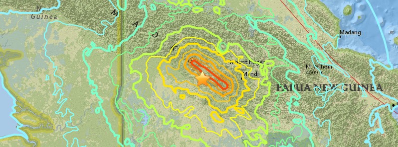
Image credit: USGS
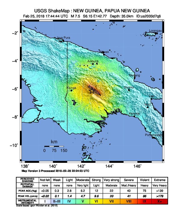
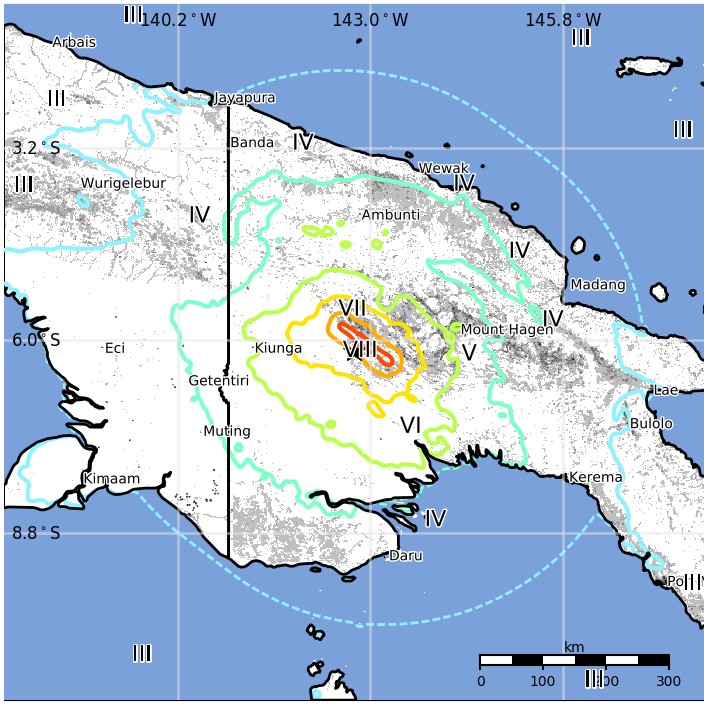
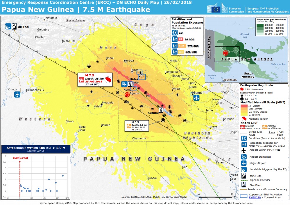
A very strong and shallow earthquake registered by the USGS as M7.5 hit Papua New Guinea at 17:44 UTC on February 25, 2018 (03:44 local time, February 26). The agency is reporting a depth of 35 km (21.7 miles). EMSC is reporting M7.5 at a depth of 30 km (18.6 miles). This earthquake is expected to have a high humanitarian impact based on the magnitude and the affected population and their vulnerability.
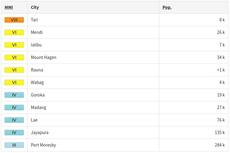
According to the USGS, the epicenter was located 33.1 km (20.5 miles) SW Tari (population 8 186), 98.5 km (61.2 miles) W of Mendi (population 26 252) and 163.4 km (101.5 miles) E of Kiunga (population 11 536), Papua New Guinea.
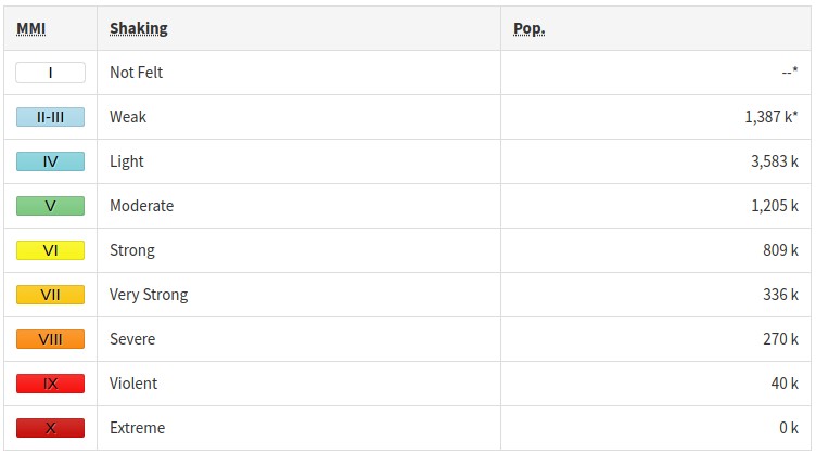
There are 670 000 people living within 100 km (62 miles) and 12 000 within 10 km.
40 000 people are estimated to have felt violent shaking, 270 000 severe, 336 000 very strong, 809 000 strong and 1 205 000 moderate.
The USGS issued an orange alert for shaking-related fatalities and economic losses. Significant casualties and damage are likely and the disaster is potentially widespread. Past orange alerts have required a regional or national level response.Estimated economic losses are less than 1% of GDP of Papua New Guinea.
Overall, the population in this region resides in structures that are a mix of vulnerable and earthquake resistant construction. The predominant vulnerable building types are unreinforced brick masonry and informal (metal, timber, GI etc.) construction.
Recent earthquakes in this area have caused secondary hazards such as tsunamis and landslides that might have contributed to losses.
A magnitude 5.5 aftershock was registered at 18:11 UTC at a depth of 39 km (24 miles).
Professor Max Wyss who specializes in theoretical prognoses of injuries and fatalities expects 10 – 300 fatalities and 100 – 1 000 people injured (ER).
Estimated population exposure to earthquake shaking
Selected cities exposed
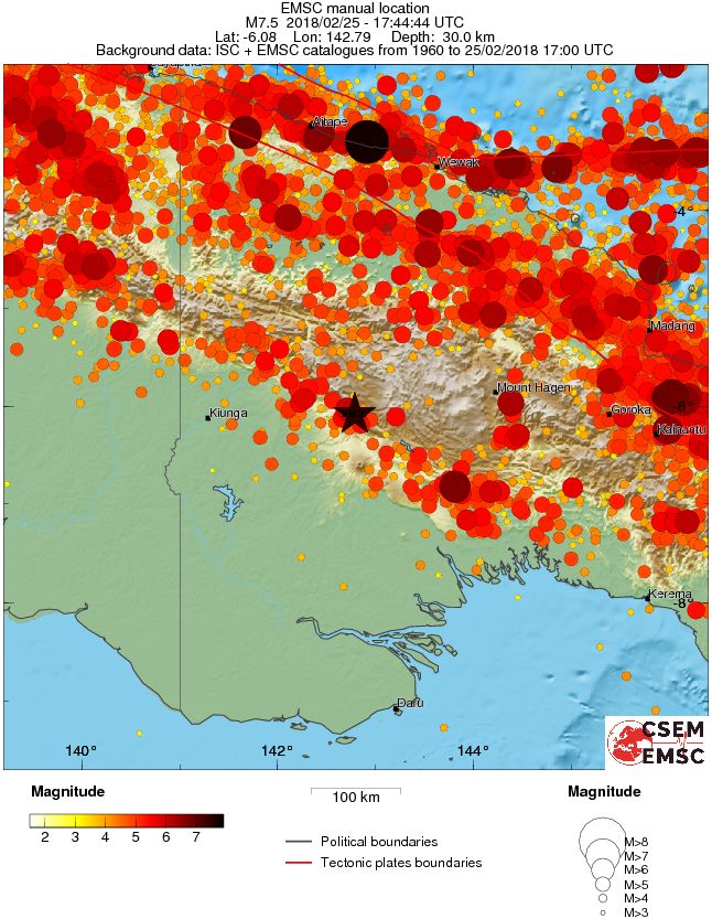
Regional seismicity
Tectonic summary
The February 25, 2018, M7.5 earthquake occurred as the result of thrust faulting at shallow a depth. Preliminary focal mechanism solutions indicate slip occurred on either a moderately dipping fault striking west-northwest, or on a moderately dipping fault striking southeast. At the location of this earthquake, the Australia plate is converging with the Pacific plate, moving towards the east-northeast with respect to Pacific lithosphere at a velocity of approximately 107 mm/yr. Earthquakes in this geographical region are generally associated with the large-scale convergence of these two major plates, and with the complex interactions of several associated microplates, most notably the South Bismarck plate, the Solomon Sea microplate, and the Woodlark plate. The location, depth, and focal mechanism solution of this earthquake are consistent with it occurring as intraplate faulting within the crust of the Australia plate.
While commonly plotted as points on maps, earthquakes of this size are more appropriately described as slip over a larger fault area. Thrust-faulting events of the size of the February 25th, 2018 earthquake are typically about 85×30 km (length x width).
Papua New Guinea experiences a high rate of seismic activity, with 23 other events of M6+ occurring within 250 km of the February 25, 2018 earthquake over the preceding century. The closest of these was a M6.2 earthquake in August 1993, about 17km to the north of today's earthquake. The largest was a M7.2 event in June 1986, 230 km to the north-northeast on or near the Australia:Pacific plate boundary in the region. With the exception of a M 7.5 earthquake at intermediate depth (186 km) in eastern Papua New Guinea in February 1963 (which occurred on the subduction zone at depth), all prior M7.5+ earthquakes in this region have been associated with the shallow subduction zone plate boundaries in northern New Guinea. The vast majority of moderate-to-large earthquakes in this region are not known to have caused significant damage or casualties, though few have been as large as today's earthquake. A M7.1 earthquake in June 1976, 340 km to the northeast of this event, resulted in over 400 shaking related deaths. Landsliding also caused a significant number of additional fatalities in that event.
Updates
February 26
06:40 UTC
At least 25 moderate to strong aftershocks hit the area between 17:44 UTC, February 25 and 05:28 UTC, February 26. Magnitudes ranged from 4.1 to 5.5.
Mobile network in this region has been disrupted, preventing initial reports of damage.
First reports coming from the local MP, Manasseh Makiba, via satellite phone said the quake was very huge and there were some casualties. "There were landslides and destruction of some properties and houses and there were reports of some lives being lost.. about ten."
The epicenter is located in a rugged, heavily forested Southern Highlands about 560 km (350 miles) NW of capital, Port Moresby. This is very close to key infrastructure for PNG's ExxonMobil-led LNG gas project.
ExxonMobil said it had shut its Hides gas conditioning plant and that it believed administration buildings, living quarters and a mess hall had been damaged. It also said it had suspended flights into the nearby Komo airfield until the runway could be surveyed.
Aid and missionary agencies said poor communications in the area made damage and injury assessment difficult. "The bush structures that they build tend to handle earthquakes extremely well," Christian missionary Brandon Buser told Reuters after contacting several remote villages by shortwave radio.
Troops and rescue workers were sent to the region.
Locals say the quake lasted between 60 and 90 seconds (and up to 150 seconds).
This is one of the most significant earthquakes ever to strike New Guinea island in recorded history.
15:48 UTC
The number of aftershocks rose to 43 at 15:17 UTC today, including M6.0 and 6.3.
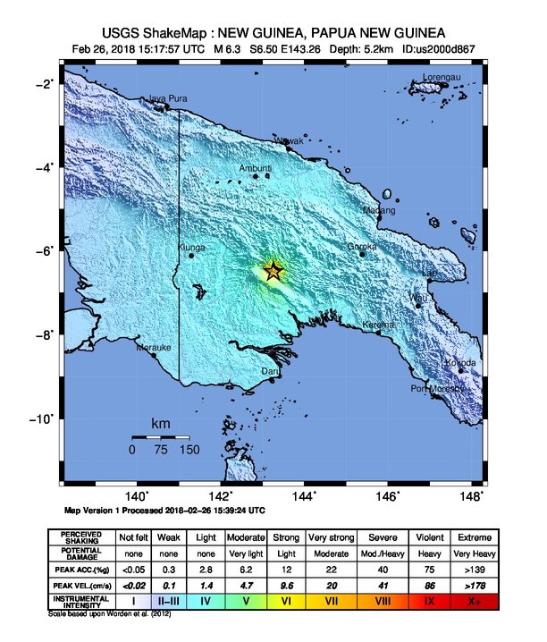
Some 18 000 people are estimated to have felt very strong shaking produced by the M6.3 quake.
February 27
13:20 UTC
The unofficial death toll has risen to 31, but there are fears of many people buried under the rubble as the quake produced massive landslides across the region. At least 300 people are confirmed injured and thousands of homes either destroyed or damaged.
March 5
Magnitude 6.0 aftershock hit Southern Highlands province of Papua New Guinea at 19:56 UTC on March 4, 2018. This is the 4th M6+ earthquake to hit this region after M7.5 mainshock on February 25.
Today's aftershock hit at a depth of 10 km (6.2 miles) as 110th M4+ earthquake to hit the region since February 25. The quake was followed by M4.9 at 20:24 UTC.
It's still unclear how many people died in the M7.5 earthquake due to severely disrupted transport and telecommunications, but PNG's Red Cross said it believes the number has reached 80.
However, unofficial reports received on Saturday, March 3, mention at least 156 deaths and at least 10 villages covered in debris after massive landslides.
The scale of devastation in Tari, a town close to the epicenter of M7.5 earthquake and home to 10 000 people, is immense, Mr. Isaac Pulupe told Radio New Zealand. Most of its buildings had collapsed, he said, including schools and parts of the hospital.
"Most people have been traumatized emotionally from all that is happening and the continual earthquakes going on," he said. "Most people, their gardens and even homes have been collapsed."
Pulupe added that most of the town is now living in tents, under tarpaulins, or ramshackle huts built from the rubble, which sometimes toppled in the near constant aftershocks.
Nearly 150 000 people remain in urgent need of emergency supplies, the director of the International Red Cross in PNG, Udaya Regmi, told Reuters on Sunday. "The quake destroyed or damaged the homes of around 7 000 people, while 147 000 were in severe need of food, water and sanitation," he said.
"The challenge is road access, it’s still not accessible to trucks and four-wheel drives," Regmi said. "Big trucks cannot go there. It’s one of the reasons the food is becoming less and less. There are no fears of starvation yet but we’ve not got the full picture."
The country has declared a state of emergency across the earthquake-hit region last week but the scale of the disaster will not be known until relief workers and authorities can complete their assessments in the area, agencies said.
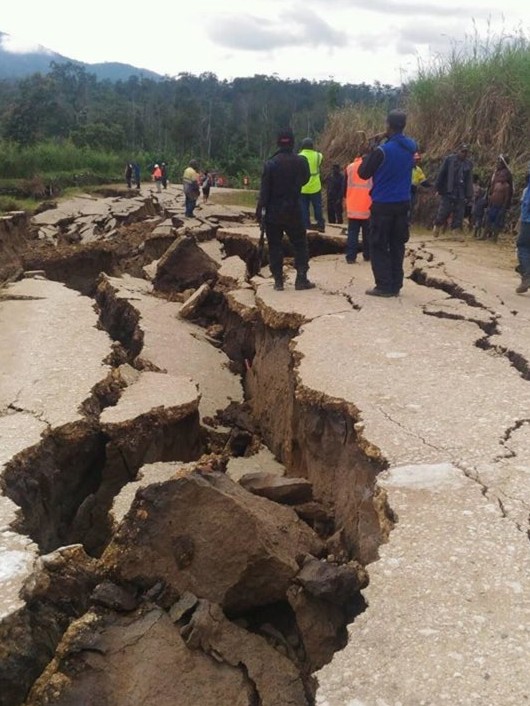
Road damage after M7.5 earthquake on February 25. Credit: Earthquake Report
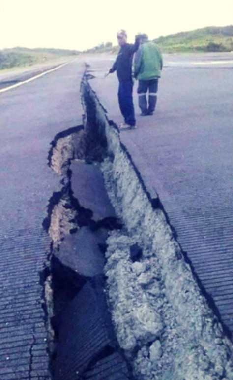
Damage to airport runway located 13 km (8 km) E of the M7.5 earthquake epicenter
Seismotectonics of the New Guinea region and vicinity
The Australia-Pacific plate boundary is over 4000 km long on the northern margin, from the Sunda (Java) trench in the west to the Solomon Islands in the east. The eastern section is over 2300 km long, extending west from northeast of the Australian continent and the Coral Sea until it intersects the east coast of Papua New Guinea. The boundary is dominated by the general northward subduction of the Australia plate.
Along the South Solomon trench, the Australia plate converges with the Pacific plate at a rate of approximately 95 mm/yr towards the east-northeast. Seismicity along the trench is dominantly related to subduction tectonics and large earthquakes are common: there have been 13 M7.5+ earthquakes recorded since 1900. On April 1, 2007, a M8.1 interplate megathrust earthquake occurred at the western end of the trench, generating a tsunami and killing at least 40 people. This was the third M8.1 megathrust event associated with this subduction zone in the past century; the other two occurred in 1939 and 1977.
Further east at the New Britain trench, the relative motions of several microplates surrounding the Australia-Pacific boundary, including north-south oriented seafloor spreading in the Woodlark Basin south of the Solomon Islands, maintain the general northward subduction of Australia-affiliated lithosphere beneath Pacific-affiliated lithosphere. Most of the large and great earthquakes east of New Guinea are related to this subduction; such earthquakes are particularly concentrated at the cusp of the trench south of New Ireland. 33 M7.5+ earthquakes have been recorded since 1900, including three shallow thrust fault M8.1 events in 1906, 1919, and 2007.
The western end of the Australia-Pacific plate boundary is perhaps the most complex portion of this boundary, extending 2000 km from Indonesia and the Banda Sea to eastern New Guinea. The boundary is dominantly convergent along an arc-continent collision segment spanning the width of New Guinea, but the regions near the edges of the impinging Australia continental margin also include relatively short segments of extensional, strike-slip and convergent deformation. The dominant convergence is accommodated by shortening and uplift across a 250-350 km-wide band of northern New Guinea, as well as by slow southward-verging subduction of the Pacific plate north of New Guinea at the New Guinea trench. Here, the Australia-Pacific plate relative velocity is approximately 110 mm/yr towards the northeast, leading to the 2-8 mm/yr uplift of the New Guinea Highlands.
Whereas the northern band of deformation is relatively diffuse east of the Indonesia-Papua New Guinea border, in western New Guinea there are at least two small (<100,000 km²) blocks of relatively undeformed lithosphere. The westernmost of these is the Birds Head Peninsula microplate in Indonesia's West Papua province, bounded on the south by the Seram trench. The Seram trench was originally interpreted as an extreme bend in the Sunda subduction zone, but is now thought to represent a southward-verging subduction zone between Birds Head and the Banda Sea.
There have been 22 M7.5+ earthquakes recorded in the New Guinea region since 1900. The dominant earthquake mechanisms are thrust and strike slip, associated with the arc-continent collision and the relative motions between numerous local microplates. The largest earthquake in the region was a M8.2 shallow thrust fault event in the northern Papua province of Indonesia that killed 166 people in 1996.
The western portion of the northern Australia plate boundary extends approximately 4800 km from New Guinea to Sumatra and primarily separates Australia from the Eurasia plate, including the Sunda block. This portion is dominantly convergent and includes subduction at the Sunda (Java) trench, and a young arc-continent collision.
In the east, this boundary extends from the Kai Islands to Sumba along the Timor trough, offset from the Sunda trench by 250 km south of Sumba. Contrary to earlier tectonic models in which this trough was interpreted as a subduction feature continuous with the Sunda subduction zone, it is now thought to represent a subsiding deformational feature related to the collision of the Australia plate continental margin and the volcanic arc of the Eurasia plate, initiating in the last 5-8 Myr. Before collision began, the Sunda subduction zone extended eastward to at least the Kai Islands, evidenced by the presence of a northward-dipping zone of seismicity beneath Timor Leste. A more detailed examination of the seismic zone along it's eastern segment reveals a gap in intermediate depth seismicity under Timor and seismic mechanisms that indicate an eastward propagating tear in the descending slab as the negatively buoyant oceanic lithosphere detaches from positively buoyant continental lithosphere. On the surface, GPS measurements indicate that the region around Timor is currently no longer connected to the Eurasia plate, but instead is moving at nearly the same velocity as the Australia plate, another consequence of collision.
Large earthquakes in eastern Indonesia occur frequently but interplate megathrust events related to subduction are rare; this is likely due to the disconnection of the descending oceanic slab from the continental margin. There have been 9 M7.5+ earthquakes recorded from the Kai Islands to Sumba since 1900. The largest was the great Banda Sea earthquake of 1938 (M8.5) an intermediate depth thrust faulting event that did not cause significant loss of life. (USGS)
I'm a dedicated researcher, journalist, and editor at The Watchers. With over 20 years of experience in the media industry, I specialize in hard science news, focusing on extreme weather, seismic and volcanic activity, space weather, and astronomy, including near-Earth objects and planetary defense strategies. You can reach me at teo /at/ watchers.news.
Thank you so much for all the effort towards producing this to enlighten us with the most significant tragic historical disaster in my beloved little country. Our prayers are with especially those who have lost their loved ones. What an unfortunate event for Papua New Guinea. Lets Gods Will be done after all..