
M3.6 earthquake hits Öræfajökull volcano, the largest on record
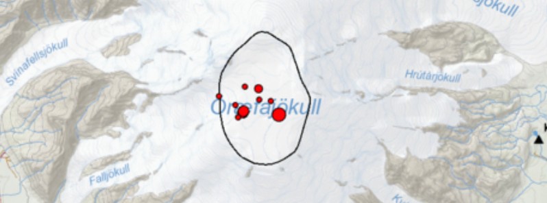
Image credit: IMO
A magnitude 3.6 earthquake was registered within the caldera of Öræfajökull volcano in Iceland at 05:07 UTC on February 9, 2018 and was followed by 10 aftershocks. This volcano is on Yellow alert since November 17, 2017 when a new ice-cauldron formed within its caldera. The last eruptive episode of this volcano started in August 1727 and ended in May 1728.
Today's earthquake is the largest recorded in Öræfajökull since instrumentation in the area started in 1976, The Icelandic Met Office said. The earthquake occurred inside the caldera just southeast of the ice-cauldron, about 1 km (0.62 miles) in diameter, that formed in November last year. The depth seems to be confined in the first few kilometers of the crust."
Öræfajökull has been showing signs of unrest for over a year, IMO said, adding that two other earthquakes larger than M3 have been recorded since last fall – M3.5 on the October 3, 2017 and M3.1 on January 18, 2018.

Oraefajokull earthquakes on February 9, 2018. Credit: IMO

Oraefajokull earthquakes on February 9, 2018. Credit: IMO
No significant changes have been observed for the past weeks with other monitoring data, including deformation, hydrological and geochemical data available to the Icelandic Meteorological Office.
An overflight, to measure glacial surface will be done as soon as the weather condition allows, IMO said. This is important as it can reflect changes of the underlying geothermal system.
In addition, satellite images will be acquired in the next days to identify possible changes of the ice-surface.
No significant changes have been seen in the satellite images this year (last image required end of January).
The last eruptive episode of this volcano started on August 3, 1727, and ended on May 1, 1728 (± 30 days). It had Volcanic Explosivity Index of 4 (on a scale of 1 – 7) and was responsible for deaths of three people.
Before that, the volcano started erupting on June 5, 1362 (± 4 days) and stopped on October 15, 1362 (± 45 days). This one had Volcanic Explosivity Index of 5 and was Iceland's largest historical explosive eruption. The volcano ejected huge amounts of tephra and destroyed the district of Litla-Hérað by floods and tephra fall. More than 40 years passed before people again settled the area, which became known as Öræfi.
Geological summary
Öraefajökull, Iceland's highest peak, is a broad glacier-clad central volcano at the SE end of the Vatnajökull icecap. A 4 x 5 km (2.5 x 3 miles) subglacial caldera truncates the summit of the dominantly basaltic and rhyolitic volcano. The extensive summit icecap is drained through deep glacial valleys dissecting the SW-to-SE flanks. The largest-volume volcano in Iceland, 2119-m-high (6 962 feet) Öraefajökull was mostly constructed during Pleistocene glacial and interglacial periods.
Holocene activity has been dominated by explosive summit eruptions, although flank lava effusions have also occurred. A major silicic eruption in 1362 CE was Iceland's largest historical explosive eruption. It and another eruption during 1727-28 were accompanied by major jökulhlaups (glacier outburst floods) that caused property damage and fatalities. (GVP).

Teo Blašković founded The Watchers in 2011 and edited it until 2026, covering seismic and volcanic activity, extreme weather, space weather and near-Earth objects. Articles on this page are his archive.
Published in the last 24 hours
- CPC posts a slight risk of heavy rain from the Gulf Coast to the Northeast urban corridor November 25-29, and a moderate risk of West Coast wind and Sierra snow on November 25
- Florida's east coast faces a moderate flash flood risk Wednesday through Friday, with 4 to 8 inches of rain forecast and the St. Johns River near Cocoa already in major flood at 17.13 feet
- Cyclone Akvan to make landfall between Nellore and Visakhapatnam around noon on November 20, IMD forecasts 120-130 km/h winds gusting to 145
