
Winter Storm Mateo dropped huge snow across British Columbia and Alberta
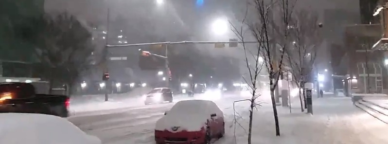
Image credit: Kyle Brittain
A winter storm rich in moisture, the same storm expected to affect areas from the Northern Rockies to the Midwest into Friday, brought huge amounts of snow to central British Columbia and Alberta, Canada over the past couple of days.
Forecasters expect upwards of 60 cm (23.6 inches) could fall across British Columbia by Friday, February 9, a huge amount for a region that has already reached its month's worth of snowfall.
"Williams Lake, B.C. has already seen around 30 cm (11.8 inches) of snow with this latest system and the average snowfall amount for the region for the entire month of February is 21.1 cm (8.3 inches). In Terrace, B.C., 56 cm (22 inches) of snow has fallen in the last two days, adding to the hefty total amount of 171 cm (67.3 inches) of snow since January 29," The Weather Network said in their today's article titled 'Jaw dropping photos from huge snow in B.C., Alberta.'
Southern Alberta saw first snow on Wednesday night, February 7, and witnessed impressive rates through the overnight hours. Authorities urged drivers to stay home if they can on Thursday with 20 to 40 cm (7.8 – 15.7 inches) of snow expected through Friday morning.
In 24 hours ending 12:00 local time Thursday, Calgary, Alberta recorded 14 cm (5.5 inches) of snow, a couple of cm shy of its greatest recorded snowfall for February 8 (19.3 cm / 7.5 inches in 1888).
INSANE snowfall rates in downtown Calgary this hour! This is for all my weather peeps and fellow Calgarians. #yyc #abstorm @DemocraticDiner @ReedTimmerAccu pic.twitter.com/IrirpFEyCG
— Kyle Brittain (@calgarywxguy) February 8, 2018
28cm in Ranchlands in NW Calgary as of 1040AM, via Matt Lerigny #yyc #abstorm pic.twitter.com/WX8RLyxGgh
— Kyle Brittain (@calgarywxguy) February 8, 2018
This winter storm, named Mateo by The Weather Channel, is already dropping snow and freezing rain on some parts of the Northern Rockies (US) as it moves to the Midwest into Friday.
Mateo is expected to spread a narrow swath of snow from Montana to New England, with the heaviest in northern High Plains and parts of the Midwest.
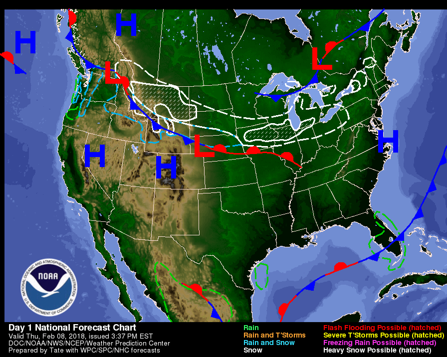
Chicago, Milwaukee, Detroit and other areas in path of this storm are expected to see poor travel conditions (snow/freezing rain).
Quite a rare sight to see freezing rain in Billings. Similar conditions are being reported from Harlowton to Billings to Hardin down to the Wyoming border along I-90. PLEASE take your time on the roads. No reason to drive fast in this. #MTwx Photo by NWS Billings Forecaster. pic.twitter.com/BkswUdb0Yh
— NWS Billings (@NWSBillings) February 8, 2018
The storm has already canceled 163 flights planned for Friday at Chicago O'Hare airport and 150 at Chicago Midway. More flights are expected to be canceled today.
Meanwhile, moisture from the Gulf of Mexico will move northward over the Gulf Coast overnight Thursday advancing as far north as the Ohio Valley and Mid-Atlantic by Saturday. Light rain with embedded thunderstorms will develop over parts of the Central/Eastern Gulf Coast by Friday afternoon.
The rain will expand northward into parts of the Ohio Valley and the Mid-Atlantic by Saturday morning.
Showers and thunderstorms will extend as far north as parts of the Middle Mississippi/Tennessee Valleys and the Southern Mid-Atlantic by Saturday.
I'm a dedicated researcher, journalist, and editor at The Watchers. With over 20 years of experience in the media industry, I specialize in hard science news, focusing on extreme weather, seismic and volcanic activity, space weather, and astronomy, including near-Earth objects and planetary defense strategies. You can reach me at teo /at/ watchers.news.
Commenting rules and guidelines
We value the thoughts and opinions of our readers and welcome healthy discussions on our website. In order to maintain a respectful and positive community, we ask that all commenters follow these rules.