
Slow-moving landslide on Rattlesnake Ridge in Washington’s Yakima County
Featured image: Rattlesnake Ridge crack on December 31, 2017. Credit: Steven Mack
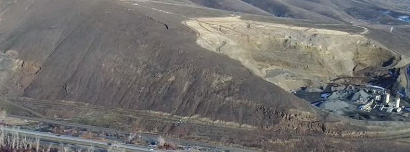
A major crack discovered on the Rattlesnake Ridge in Yakima County, Washington in October 2017 is spreading some 6.3 cm (2.5 inches) per day, officials said. This slow-moving landslide is now threatening to dump as much as 765 500 m3 (1 million cubic yards) of rock down the ridge, but most of it is expected to be trapped in a quarry and not reach Interstate 82 or the Yakima River. Roughly 50 residents living near the base of the ridge have been warned to evacuate.
The area of concern is on the east side of the Union Gap, east of Thorp Road near the Columbia aka Anderson Quarry, officials said.
"With this type of incident, there is no definitive answer as to if or when significant movement of the slide will occur or how far the slide will travel. The geologic experts that have been monitoring this slide believe that since the slide is slow moving and on a gentle slope that the landslide event will be small in nature and hopefully stabilize itself," the Yakima Valley Office of Emergency Management said in a press release.
Rattlesnake Ridge crack on December 31, 2017. Credit: Steven Mack
Video courtesy KING5
It's unclear when the crack first formed but officials are monitoring it since October and have started creating what will eventually be a 180 meters (600 feet) of concrete-filled shipping containers between the base of the ridge at the Thorp Road and nearby Interstate 82. The containers are intended to defend the interstate against moderate rockfall, officials said, but won't protect from a major landslide.
According to George Machan, a senior associate geotechnical engineer with Cornforth Consultants, the landslide is projected to occur sometime between now and the end of February 2018.
Video courtesy KING5
Machan said there is an extremely remote possibility that some of the estimated 380 000 – 765 000 m3 (500 000 – 1 million cubic yards) of material is going to get into the river. Instead, most of it is expected to fall into the quarry pit and stabilize.
However, as the slow-moving slide, which is moving at an average of 6.3 cm (2.5 inches) per day, the surrounding areas could see increased rockfall, he said.
Emergency Management is preparing for a variety of different case scenarios, the Yakima Valley OEM said.
Thorp Road between Birchfield Road and Gangl Road will remain closed until further notice, it said. "The homes along Thorp Road south of the Quarry have been put on a Level 3 – Recommended evacuation. I-82 is still open but WSDOT is monitoring the area for rockfall but so far has not seen any. If WSDOT feels that the Intestate has become unsafe they will close it. In the meantime, they have placed signs along the highway alerting drivers of the potential for rockfall."
I'm a dedicated researcher, journalist, and editor at The Watchers. With over 20 years of experience in the media industry, I specialize in hard science news, focusing on extreme weather, seismic and volcanic activity, space weather, and astronomy, including near-Earth objects and planetary defense strategies. You can reach me at teo /at/ watchers.news.
Is the slide occuring moving east, south , west or north? I have this philosophy that a volcano with small activity can stretch the ground at large distances. Is it Yellowstone or the west coast volcanoes? I believe for example that the Idaho earthquakes are Yellowstone related. Years ago I dreamed of a sinkhole showing up, considerable time before they did all over the world. I also dreamed that a huge flood came inland and made Mt. Spokane into an island. It was so huge and we could not get away from it. I don’t know where that water came from, very scary indeed.