
Strong eruption at Mount Sinabung, large pyroclastic flow generated
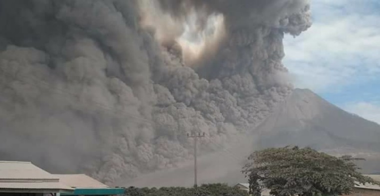
Featured image: Eruption and pyroclastic flow at Mount Sinabung on August 2, 2017. Credit: Eliana Permata Tarigan
Indonesia's Sinabung volcano erupted at 01:10 UTC (08:10 local time) on August 2, 2017, ejecting a plume of ash and smoke up to 5.4 km (18 000 feet) above sea level. It was one of Sinabung's biggest eruptions in the past several months. By 05:10 UTC, there were at least 19 reported eruptions, up from about 2 to 8 per day. The Aviation Color Code is Orange. There were no reports of casualties.
The eruptions produced a large pyroclastic flow at 03:04 UTC (08:04 local time). The flow tumbled down the east and southeast slopes as far as 4.5 km (2.8 miles), reaching the Labortus River and creating a natural dam on its upper reaches.
By 03:30 UTC, volcanic ash cloud was reaching a height of 5.4 km (18 000 feet) above sea level, according to the Darwin VAAC.
According to local media reports, students from an elementary school in Kuta Rakyat were sent home because volcanic ash covering the village was considered dangerous.
National Disaster Mitigation Agency spokesman Sutopo Purwo Nugroho said, as reported by the AFP, thousands of people in 10 villages were directly affected by ash fall. He warned villagers to stay out of a danger zone that extends as far as 7 km (4.4 miles) from the peak.
Nugroho said villagers urgently need face masks and clean water and called on people to be vigilant about the possibility of flash floods and lava flows because the eruption created a natural dam on the Laborus River.
Sinabung's first eruption in known history took place in August 2010. It lasted about a month and had Volcanic Explosivity Index of 2.
Seismicity fluctuated until September 2013, when dense white plumes started rising 100 to 150 m (328 to 492 feet) above the crater. Sinabung's first major eruption in known history occurred on September 17, 2013 and the volcano remains active ever since. Tens of thousands have been evacuated.
Between February 2014 and May 2016, eruptions at Mount Sinabung claimed lives of 23 people.
Geological summary
Gunung Sinabung is a Pleistocene-to-Holocene stratovolcano with many lava flows on its flanks. The migration of summit vents along a N-S line gives the summit crater complex an elongated form. The youngest crater of this conical, 2 460-m-high (8 070 feet) andesitic-to-dacitic volcano is at the southern end of the four overlapping summit craters.
An unconfirmed eruption was noted in 1881, and solfataric activity was seen at the summit and upper flanks in 1912.
No confirmed historical eruptions were recorded prior to explosive eruptions during August – September 2010 that produced ash plumes to 5 km (16 404 feet) above the summit. (GVP)
I'm a dedicated researcher, journalist, and editor at The Watchers. With over 20 years of experience in the media industry, I specialize in hard science news, focusing on extreme weather, seismic and volcanic activity, space weather, and astronomy, including near-Earth objects and planetary defense strategies. You can reach me at teo /at/ watchers.news.
Commenting rules and guidelines
We value the thoughts and opinions of our readers and welcome healthy discussions on our website. In order to maintain a respectful and positive community, we ask that all commenters follow these rules.