
Extreme rainfall event affecting eastern Canada
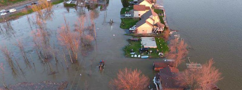
Image credit: Leanne Diy'er
A slow-moving weather system moving up from the southern United States is dumping heavy rain on parts of eastern Canada, especially Ontario where month's worth of rain in just 48 hours caused severe flooding problems in nation's capital region. Quebec was hardest hit, with more than 1 300 homes affected by floods. With grounds already saturated and more heavy rain in the forecast, meteorologists warn the worst is yet to come.
Rainfall is expected to continue across southern and eastern Ontario over the weekend. With the ground already saturated from days of rain and showers, many watersheds have issued water level statements, flood watches and flood warnings.
"With up to 70 mm (2.8 inches) of rain in the forecast for the Toronto area, and even higher in the southwest, the province's rivers are swollen, with high water levels on Lake Ontario adding to the flood risk. As of Friday evening, Toronto had already picked up 43 mm (1.7 inches) of rain and counting. Anywhere from 50 to 70 mm (2 – 2.8 inches) of rainfall are expected through Sunday," The Weather Network (TWN) said.
Flood warnings, watches and advisories are widespread across the south of the province, and residents of the Toronto Islands are being asked to prepare to evacuate as a precaution, with emergency evacuation plans drawn up by the city. The plans include leaving a ferry docked at the island overnight in case an evacuation of the area's 700 permanent residents becomes necessary.
"Normally, even up to 70 mm of rain over a 12 hour period would not be too much of a concern for southern Ontario waterways. However, this system is coming on the heels of around two and a half days of rainfall, which delivered between 25 – 30 mm [1 – 1.2 inches] of rain across parts of southwestern Ontario and the GTA (with higher amounts in some localized areas), and even up to 50 mm [2 inches] or more in areas like Barrie, Peterborough and across parts of eastern Ontario," TWN said.
Additionally, along with many rivers and streams running at higher than normal levels for this time of year, Lake Ontario is currently at around 60 cm (1.96 feet) higher than average – its highest levels since 1993.
In neighboring Quebec, rivers in the Pierrefonds and Île Bizard areas have swelled dramatically, flooding nearby homes and roads. More than 1 300 homes have been affected, and flood emergencies are ongoing (as of late Friday, May 5, local time) in more than a hundred Quebec municipalities.
The system will then move into Atlantic Canada, bringing similar deluges. It will most likely hit New Brunswick the hardest.
"The rain will begin over southwestern regions this evening (Friday) and then spread to the rest of province overnight," Environment Canada says. "Rainfall amounts of at least 50 mm are forecast by Saturday evening for most of the southern half of the province. These amounts will approach 100 mm total over southwestern regions."
New Brunswick authorities warned people in St. John River valley to prepare for the possibility of flooding.
I'm a dedicated researcher, journalist, and editor at The Watchers. With over 20 years of experience in the media industry, I specialize in hard science news, focusing on extreme weather, seismic and volcanic activity, space weather, and astronomy, including near-Earth objects and planetary defense strategies. You can reach me at teo /at/ watchers.news.
Commenting rules and guidelines
We value the thoughts and opinions of our readers and welcome healthy discussions on our website. In order to maintain a respectful and positive community, we ask that all commenters follow these rules.