Hurricane force low sends huge chunks of ice into Newfoundland

Car and house-sized chunks of broken-up sea ice are being pounded onto the shore of St. John's harbor today, as a hurricane-force low continues to produce powerful winds, heavy rain and blizzard conditions in parts of Canada's Newfoundland and Labrador province. Locals say they haven't seen such sight since the 1980's.
Blizzard conditions continue for central and northern portions of the island, with additional snowfall accumulations of 20 – 40 cm (7.9 – 15.7 inches) in the forecast, The Weather Network meteorologists said.
Rain, at times heavy, will continue today but rain will change over to snow this afternoon over the northern Avalon and taper to drizzle over the southeastern Avalon, according to the Environment Canada. Persistent strong winds along the east and northeast coasts will also result in extensive ice buildup and pounding surf, especially north of Cape St. Francis.
Weather Network reporters Mark Robinson and Chris St. Clair were at the Avalon Peninsula Thursday and found car and house-sized chunks of broken-up sea ice being pounded onto shore by the normal course of tidal action. The ice continues to enter the St. John's harbor Friday, they said and added that these chunks are huge but compared to what's out at sea are 'really quite small.'
Video courtesy The Weather Network
Video courtesy The Weather Network
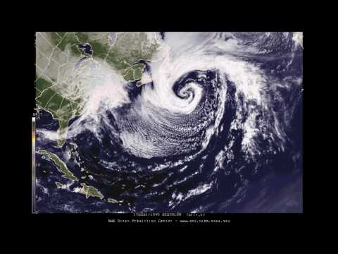
The video below shows the development of this hurricane force low in the West Atlantic. The low started out to the south of Bermuda, and it strengthened while moving NE. It then merged with a northern stream low that moved off the New England coast. The combined system intensified to hurricane force to the SE of Newfoundland earlier this morning.


An extratropical/post-tropical low pressure system is classified as "hurricane force" when the winds are greater than or equal to 118 km/h (73 mph). Video courtesy NWS OPC
The estimated central pressure of the storm was 964 hPa Friday morning. Significant wave heights up to 12.5 m (41 feet) were measured south of the low pressure center.
The weather in the province is expected to improve overnight into Saturday morning, April 1.
Featured image: Hurricane force low sends huge chunks of ice into Newfoundland. Credit: The Weather Network

Commenting rules and guidelines
We value the thoughts and opinions of our readers and welcome healthy discussions on our website. In order to maintain a respectful and positive community, we ask that all commenters follow these rules:
We reserve the right to remove any comments that violate these rules. By commenting on our website, you agree to abide by these guidelines. Thank you for helping to create a positive and welcoming environment for all.