
Wildfires threaten New Zealand’s Christchurch
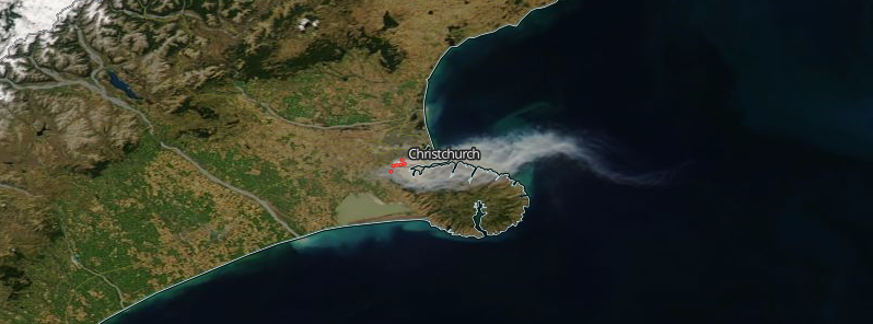
Featured image: Wildfires threaten Christchurch, New Zealand - February 15, 2017. Credit: NASA Aqua/MODIS
A state of emergency has been declared in New Zealand's Christchurch as wildfires threatened its suburbs on February 15, 2017, forcing up to 1 000 people to evacuate. As of early UTC morning, at least one person has been killed and 5 homes destroyed.
Christchurch residents were told to prepare to evacuate at short notice as of 03:00 local time tonight as wildfires reached dangerously close to Port Hills.
“It’s gone from being a rural fire on the boundary between a city and a district, now to a city response being required,” Christchurch Mayor Lianne Dalziel stated during an interview with Radio New Zealand. “Every window you look out of … you can just see the pall of the smoke.”
State of emergency has been declared for Christchurch City and Selwyn District.
At least five homes have been lost in Christchurch since yesterday. Tens of thousands homes in the city suffered power loss during the afternoon hours as wildfires continued to burn.
People have been told to stay indoors to avoid smoke inhalation.
The fires are burning since Monday evening when two separate fires broke out. The situation worsened after a change of wind direction flared up the fire overnight on Wednesday, pushing the flames in the direction of houses and burning roughly 50 hectares (123 acres) of land in the process, news agencies reported.
Flames were reportedly as high as 20 meters (65 feet).
Since Monday, approximately 650 hectares (1 606 acres) of land has been burned.
According to NZHerald, evacuations are currently happening in the following areas:
• Worsley Rd
• Hoon Hay Rd – from Cashmere Rd, and
• Kennedys Bush Rd – from Cashmere Rd.
• Dyers Pass Rd has also been evacuated from Sign of the Takahe
• Early Valley Rd
Road Closures
• Cashmere Rd is closed west of Kaiwara St through to Kennedys Bush Rd.
• Worsleys Rd is closed
• Hoon Hay Valley Rd is closed
• Kennedys Bush Rd is closed form the roundabout with Rock Hill Drive. This includes the southbound cycle track
• Worsleys Track from Worlseys Rd is closed
• Dyers Pass Rd is closed between Hackthorne Rd to Governors Bay Rd. Use the Lyttelton Tunnel or Gebbies Pass as the alternate route
• Summit Rd is closed between Gebbies Pass and Rapaki Track
• Old Tai Tapu Rd is closed between Osterholts Rd and Early Valley Rd
• Early Valley Rd is closed
• Holmes Rd is closed.
The Watchers team and our contributors bring the latest on extreme weather, earthquakes, volcanic eruptions, space weather, and all things science. We're all about making sense of the natural world and keeping you informed on what’s happening. Got a tip or a question? Hit us up using the form at newstips!
Commenting rules and guidelines
We value the thoughts and opinions of our readers and welcome healthy discussions on our website. In order to maintain a respectful and positive community, we ask that all commenters follow these rules.