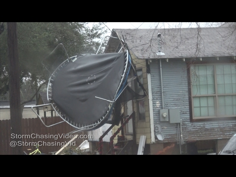
Severe thunderstorms hit Texas, moving toward Florida

A line of severe storms moved east through southeastern Texas early Tuesday morning (local time), February 14, 2017, destroying several homes and injuring at least two people.
Tornadoes touched down in several locations across southeast Texas today with thunderstorms moving right through the center of Houston.
A confirmed tornado was first reported at 08:20 a.m. near Rosenberg in Fort Bend County. Several homes, trees and fences were destroyed in the area.
Significant damage to homes and other buildings was later reported in the Bridlewood neighborhood near Richmond.
About 08:30, another tornado reportedly touched down near Greatwood in First Colony, Fort Bend County. Significant damage was also reported in Stafford, Missouri City and in the Van Vleck area of Matagorda County.


Nearly 21 000 homes lost power at the height of the storm.
The National Weather Service said storm survey teams are being sent to Rosenberg, Richmond, Stafford, Wharton, El Campo, Van Vleck and Sweeney areas.
9:30 AM Radar Update: Severe storms continue to move eastward through SE Texas. Take shelter if you are in a warning! #houwx #txwx pic.twitter.com/ivXmvIv3vR
— NWS Houston (@NWSHouston) February 14, 2017
2-story RV garage in Bridlewood. We have closed the neighborhood to non-residents. #HouWx pic.twitter.com/MBMbLuyjFN
— FBCSO Texas (@FBCSO) February 14, 2017
Storms have cleared the Houston metro and will continue to push out of SE Texas over the next hour or so. Marine impacts may linger longer. pic.twitter.com/LovxMiZHTA
— NWS Houston (@NWSHouston) February 14, 2017
Storm damage in Bridlewood Estates subdivision in Fort Bend County. Thankfully, it doesn't appear that anyone was hurt. pic.twitter.com/2XhQyaNvjr
— Tim Wetzel (@KHOUTim) February 14, 2017
Pretty obvious path through the trees to this 2-story garage. @NWSHouston #HouWx pic.twitter.com/cp54OYJrrX
— FBCSO Texas (@FBCSO) February 14, 2017
The NWS Storm Prediction Center is forecasting a slight risk for severe thunderstorms in the Southern Plains and Lower Mississippi Valley today. The greatest potential for isolated tornado development is from southeast Texas to the Florida panhandle. Convective weather is forecast to move into the southeastern states and Florida Wednesday.
Featured image: Damage in southeastern Texas after severe thunderstorms on February 14, 2017. Credit: FBSCO Texas

Commenting rules and guidelines
We value the thoughts and opinions of our readers and welcome healthy discussions on our website. In order to maintain a respectful and positive community, we ask that all commenters follow these rules:
We reserve the right to remove any comments that violate these rules. By commenting on our website, you agree to abide by these guidelines. Thank you for helping to create a positive and welcoming environment for all.