
West Antarctic Ice Sheet breaking apart from the inside out
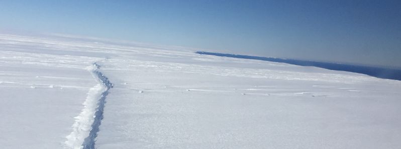
Featured image: A rift in Pine Island Glacier ice shelf, West Antarctica, photographed from the air during a NASA Operation IceBridge survey flight on November 4, 2016. Image credit NASA/Nathan Kurtz
A new study has found the glacier bounding the West Antarctic Ice Sheet is breaking apart from the inside out.
The Pine Island Glacier, one of the glaciers which will probably rapidly retreat, forms an important part of the ice shelf of the West Antarctic Ice Sheet.
Over half of the world's fresh water reservoir is currently frozen in Antarctica. The Pine Island Glacier and the Thwaites Glacier block the ice flow on the continent, keeping about 10% of the Ice Sheet from draining away into the sea.
About 582.7 square kilometers (225 square miles) large iceberg broke off the glacier in 2015. While observing the satellite images of the area in 2013, the scientists noted evidence of a rift forming at the base of the ice shelf, about 32.2 km (20 miles) inland. This rift moved upward over the next two years and broke through the ice surface, setting the iceberg adrift for more than 12 days during July and August 2015.
“It’s generally accepted that it’s no longer a question of whether the West Antarctic Ice Sheet will melt, it’s a question of when, This kind of rifting behavior provides another mechanism for rapid retreat of these glaciers, adding to the probability that we may see significant collapse of West Antarctica in our lifetimes.” said Ian Howat, an associate professor of earth sciences at Ohio State and a leader of the study.
This discovery is the first in the Antarctic, although similar situations have been previously observed in the Greenland Ice Sheet, in regions where the water from the ocean would seep inland and begin melting the ice from below.
Video credit: Seongsu Jeong, The Ohio State University.
According to the scientists, the satellite images present the first solid evidence of how the Antarctic ice reacts to changes occurring at the ocean edge.
“Rifts usually form at the margins of an ice shelf, where the ice is thin and subject to shearing that rips it apart. However, this latest event in the Pine Island Glacier was due to a rift that originated from the center of the ice shelf and propagated out to the margins. This implies that something weakened the center of the ice shelf, with the most likely explanation being a crevasse melted out at the bedrock level by a warming ocean,” said Howat.
The bottom of the West Antarctic Ice Sheet is situated below the sea level, so the water from the ocean may intrude far inland without detection. The valleys which can form on the surface can indicate the ice below is in the process of melting.
Due to the lucky circumstances, the Landsat – 8 images were collected while the sun was low and the long shadows cast across have driven the attention to the forming valley. Otherwise, the rift origin in the Pine Island Glacier would have remained undetected.
“The really troubling thing is that there are many of these valleys further up-glacier. If they are actually sites of weakness that are prone to rifting, we could potentially see more accelerated ice loss in Antarctica,” explained Howat.
.jpg)
A rift in Pine Island Glacier ice shelf, West Antarctica, photographed from the air during a NASA Operation IceBridge survey flight on November 4, 2016. Image credit NASA/Nathan Kurtz
According to the researchers, the West Antarctic Ice Sheet is quite unstable, and it may collapse over the next 100 years. This would cause the sea level to rise for about 3 m (10 feet), flooding the coastal communities and displacing about 150 million people across the globe.
“We need to understand exactly how these valleys and rifts form, and what they mean for ice shelf stability. We're limited in what information we can get from space, so this will mean targeting air and field campaigns to collect more detailed observations. The U.S. and the U.K. are partnering on a large field science program targeted at that area of Antarctica, so this will provide another piece to the puzzle,” concluded Howat.
See also:
Researchers find surprisingly high geothermal heating beneath West Antarctic Ice Sheet
Is it possible to get weekly or monthly updates on earthquakes: depth, size and location, (Date) in Antartic Or is the Antartic relatively stable? Location of known volcanoes? Any discovery of fossils in mountains on Antartic? Have rafters from meteorites been discovered and if so, where?
So that’s it. Like a growing cancer the West Antarctic Ice Sheet is rotting from the inside out. And that’s really, really bad news — for those born today or in recent years. For the rest of us, especially those around age 50 or more, no big deal. The rot won’t be complete in our lifetimes. It’s not that we don’t care about you it’s just that nothing can be done about it, whether in the Antarctic or the Arctic. Time for a scotch and cookie.
Pine Island Glacier ripped open in 2015 while Larsen C ripped open in 2016 – both during the winter.
If this isn’t alarming enough, we have the 8,000 glacial lakes that also suddenly appeared during the 2016 Antarctic winter.
As glacial melt inundates the sea waters, glaciologists tell us the water temperatures are five to ten degrees above freezing.
If that doesn’t prompt you to pause and ponder, perhaps you’re allowing the experts-on-parade to do your thinking for you.
Those who have failed to figure out what’s going on are in the news, shrugging their shoulders while stuffing their pockets with public funds as the ice streams and glacial lakes melt the ice shelves from the top while drilling downward to the sea –
simultaneously the 5C water temperatures are melting the ice shelves from below.
With 14 weeks of record-breaking heat ahead, the rapid melting and rapid weakening of the ice shelves will continue to escalate.
Our France-sized Ross Ice Shelf – with a couple dozen giant glaciers resting on it – is the most life-threatening of all the ice shelves.
If the experts-on-parade had any intelligence at all, monitors would already be installed on all the seamounts that are beneath and alongside the Ross Ice Shelf.
All the seamounts in Amundsen also need monitors to detect the heat and monitor the explosions.
Underwater video cameras on all those seamounts with online livestreaming for public access is also vital.
However, since the experts-on-parade have chosen to instead drill, drill, drill –
this tells us everything we need to know.
For those who didn’t notice, NASA is bragging about logging 300 hours over Antarctica over the past couple months while offering only two minutes of that video footage to the public.
Antarctic reports from glaciologists are compiled on my discussion page –
I’ve been monitoring glacial melt all across the world for nearly 20 years and have tracked it backward in time over 600 years –
I also monitor record-breaking rainfall – which is the result of an exponential increase in evaporation which is the result of an exponential increase in heat coming off the ocean waters which is the result of an exponential increase in heat coming off the seamounts all across the world which is why the Arctic is heating up faster than any place on Earth – because the Arctic Ocean is the most shallow of all the oceans which results in the sea water there warmer up faster than any place else on Earth.
Thousands of links to reports, translated from over a dozen languages, are here:
youtube.com/whirledpublishing/discussion