
Series of earthquakes hit Oklahoma
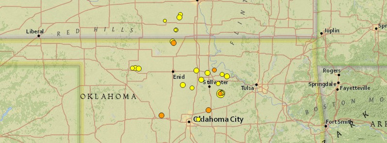
Image credit: USGS
A series of earthquakes hit parts of Oklahoma on November 11, 2016, just days after damaging M5.0 in Cushing, north-central Oklahoma, one of the world's key oil hubs.
Between 00:08 and 15:49 UTC today, USGS registered a total of 6 earthquakes with magnitudes between 2.5 and 3.0.
Today's quakes come just 4 days after a sharp M5.0 earthquake hit the city of Cushing in Payne County, a key world oil hub, at 01:44 UTC on November 7, 2016. That quake, however, was the strongest after M5.8, the strongest earthquake in Oklahoma's history, hit Pawnee and forced shutdowns of 37 oil wells.
Oklahoma governor Mary Fallin declared a state of emergency for Payne County on Tuesday, November 8. The authorities shut down 7 more disposal wells and reduced volumes of 47 others.
In recent years, Oklahoma has had thousands of earthquakes. Nearly all have been traced to the underground injection of wastewater left over from oil and gas production.
Over the past 7 days, Oklahoma and neighboring Kansas were hit by 32 earthquakes, according to the USGS, with magnitudes between 1.4 and 5.0.
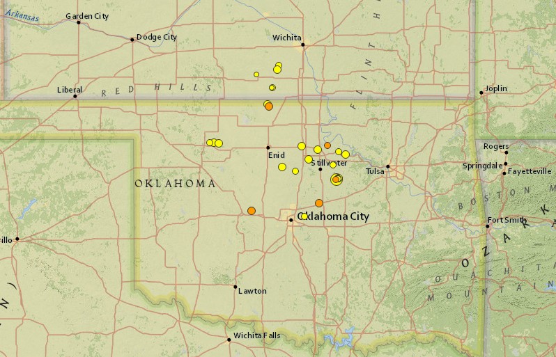
Image credit: USGS
- 3.0
11km ENE of Luther, Oklahoma
2016-11-11 15:49:56 (UTC)
- 3.0
17km NW of Medford, Oklahoma
2016-11-11 11:12:36 (UTC)
- 3.3
16km ESE of Geary, Oklahoma
2016-11-11 08:54:44 (UTC)
- 2.6
16km ESE of Geary, Oklahoma
2016-11-11 04:22:43 (UTC)
- 2.5
15km NW of Pawnee, Oklahoma
2016-11-11 00:44:27 (UTC)
- 2.9
4km W of Cushing, Oklahoma
2016-11-11 00:08:05 (UTC)
- 2.7
20km NE of Crescent, Oklahoma
2016-11-10 21:21:36 (UTC)
- 2.4
1km NNW of Cushing, Oklahoma
2016-11-09 22:18:01 (UTC)
- 1.4
1km NNW of Cushing, Oklahoma
2016-11-09 16:54:14 (UTC)
- 3.7
20km NW of Medford, Oklahoma
2016-11-09 02:15:37 (UTC)
- 2.0
1km NNW of Cushing, Oklahoma
2016-11-09 01:51:56 (UTC)
- 3.3
15km NNW of Perry, Oklahoma
2016-11-08 20:27:05 (UTC)
- 2.1
1km NNW of Cushing, Oklahoma
2016-11-08 04:03:56 (UTC)
- 2.7
35km NW of Fairview, Oklahoma
2016-11-07 22:17:14 (UTC)
- 3.2
25km NW of Fairview, Oklahoma
2016-11-07 13:43:17 (UTC)
- 1.7
19km E of Anthony, Kansas
2016-11-07 12:48:56 (UTC)
- 2.9
2km NNE of Nicoma Park, Oklahoma
2016-11-07 08:46:44 (UTC)
- 3.8
31km NW of Fairview, Oklahoma
2016-11-07 07:33:59 (UTC)
- 2.7
19km E of Anthony, Kansas
2016-11-07 07:01:43 (UTC)
- 3.1
8km W of Conway Springs, Kansas
2016-11-07 04:52:35 (UTC)
- 2.6
2km NNW of Cushing, Oklahoma
2016-11-07 02:23:22 (UTC)
- 3.0
2km N of Cushing, Oklahoma
2016-11-07 01:52:32 (UTC)
- 2.5
1km NNW of Cushing, Oklahoma
2016-11-07 01:52:29 (UTC)
- 5.0
2km W of Cushing, Oklahoma
2016-11-07 01:44:24 (UTC)
- 3.1
19km ENE of Perry, Oklahoma
2016-11-06 19:43:07 (UTC)
- 3.6
6km SE of Perry, Oklahoma
2016-11-06 03:20:43 (UTC)
- 1.9
4km NW of Harper, Kansas
2016-11-05 23:21:07 (UTC)
- 2.9
2km E of Pawnee, Oklahoma
2016-11-05 15:40:31 (UTC)
- 2.8
15km WNW of Yale, Oklahoma
2016-11-05 11:52:50 (UTC)
- 3.7
13km ESE of Pawnee, Oklahoma
2016-11-05 09:39:43 (UTC)
- 2.9
7km NW of Conway Springs, Kansas
2016-11-05 09:20:19 (UTC)
- 3.3
22km ENE of Hennessey, Oklahoma
2016-11-04 23:06:45 (UTC)
The Watchers team and our contributors bring the latest on extreme weather, earthquakes, volcanic eruptions, space weather, and all things science. We're all about making sense of the natural world and keeping you informed on what’s happening. Got a tip or a question? Hit us up using the form at newstips!
Commenting rules and guidelines
We value the thoughts and opinions of our readers and welcome healthy discussions on our website. In order to maintain a respectful and positive community, we ask that all commenters follow these rules.