
Typhoon “Sarika” hits the Philippines, heads toward Hainan and Vietnam
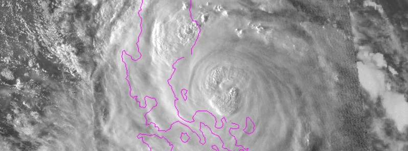
Image credit: NOAA, JMA/Himawari
Typhoon "Sarika" is making landfall in the Visayas, the central region of the Philippines on October 15, 2016 with maximum sustained winds near 166 km/h (103 mph).
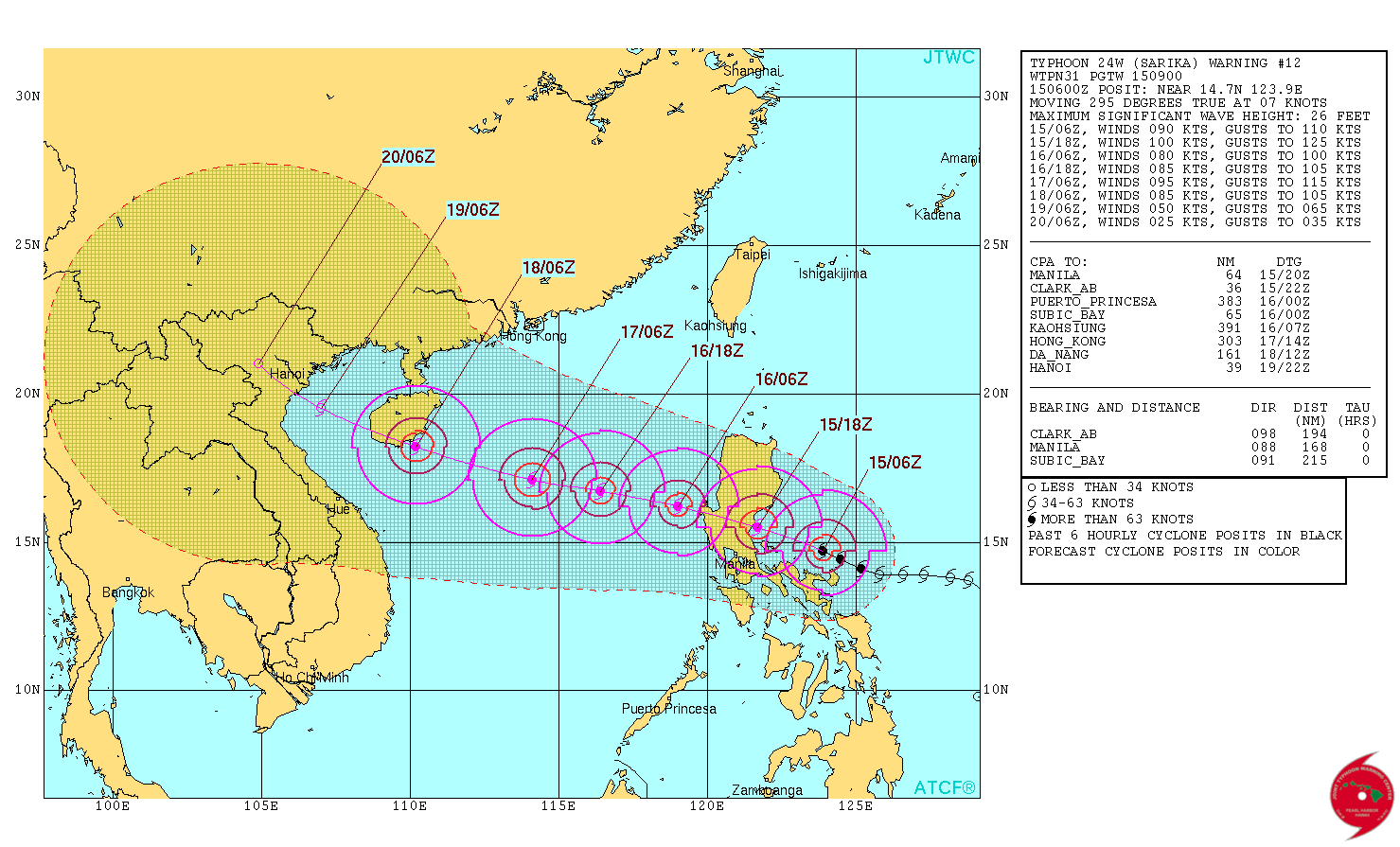
At 09:00 UTC, the system was located about 311 km (193 miles) east of Manila, and tracking west-northwest at 12.9 km/h (8 mph), according to the Joint Typhoon Warning Center (JTWC). Sarika is expected to cross over Luzon, the northern Philippines during the day, and continue moving into the South China Sea.
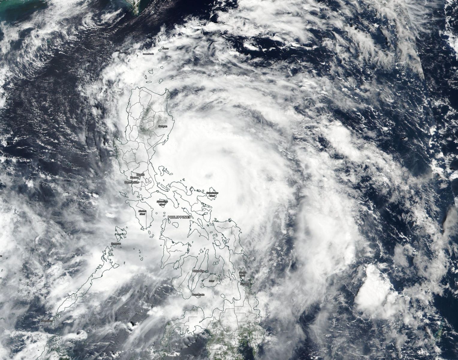
Typhoon "Sarika" approaching the Philippines, October 15, 2016. Image credit: NASA/Suomi NPP/VIIRS
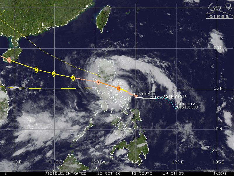
Typhoon Sarika, October 15, 2016, 12:30 UTC. Image credit: UW-CIMSS
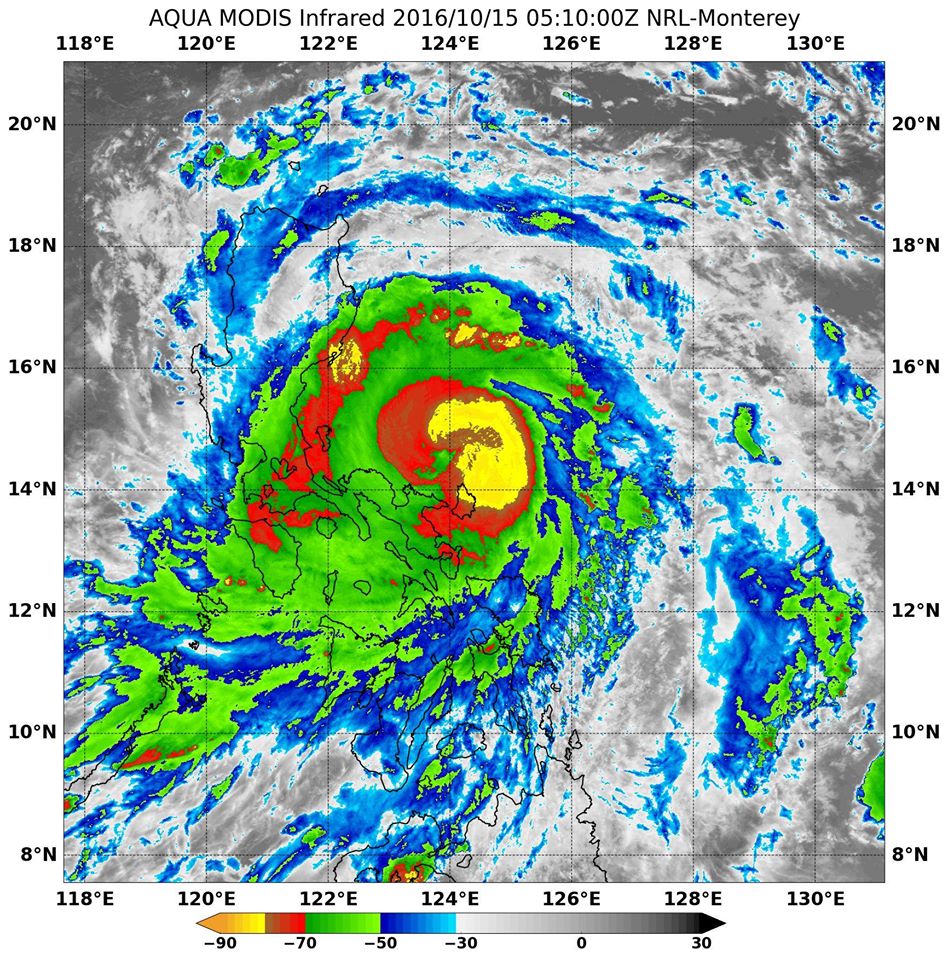
Typhoon Sarika making landfall in the Philippines, October 15, 2016. Image credit: NASA
According to meteorologists from Westpacwx, the storm is expected to lash most of central and south Luzon with heavy rainfall and damaging winds. Landslides are also possible in higher elevations.
Public storm warning signal #3 is currently in effect in the Luzon provinces of Pangasinan, Northern Zambales, Tarlac, Nueva Ecija, Aurora, and Northern Quezon, including Polilio Island, La Union, Benguet, Nueva Vizcaya and Quirino.
Public storm warning signal #2 is in effect in the Luzon provinces of Ilocos Sur, Southern Isabela, Mt Province, Ifugao, Rest of Zambales, Pampanga, Bulacan, Bataan, Rizal, Metro Manila, Rest of Quezon, Camarines Norte and Catanduanes.
Public storm signal #1 is in force in the Luzon provinces of Ilocos Norte, Abra, Kalinga, Rest of Isabela, Southern Apayao, Southern Cagayan, Oriental Mindoro, Cavite, Batangas, Laguna, Marinduque, Camarines Sur, and Albay, including Burias Island.
Typhoon "Sarika" 5-day forecast track. Image credit: JTWC
New threat – Tropical Storm "Haima"
Tropical Storm "Haima" was officially designated by the Japan Meteorological Agency (JMA) this morning, October 15.
The system will travel west-northwest, and become more northwesterly in the midst of its track, which will take it extremely close to northern Luzon.
At the time it is expected to develop into a Category 4 hurricane, and residents of western Micronesia and the Philippines are advised to monitor the storm closely.
Update
21:30 UTC, Sunday, October 16, 2016
Typhoon "Sarika" made landfall in Aurora Province around 18:30 UTC on Saturday, October 15 (02:30 local time on October 16), causing at least two fatalities and prompting pre-emptive evacuations of more than 15 000 people. At least 3 people are reportedly missing.
Sarika had wind speed of 150 km/h (93.2 mph) before making landfall.
Strong winds and rain knocked down trees and power lines, causing power outages and floods in five provinces.
Roofs of many houses were ripped off, as the storm ripped through heavily populated agricultural provinces.
Typhoon #Sarika reached Cat. 4 status before making landfall on Luzon – the 8th Cat. 4-5 typhoon of 2016. Average to date is about 5. pic.twitter.com/kTYc7njvyq
— Philip Klotzbach (@philklotzbach) October 15, 2016
In the Catanduanes Province, a man drowned after being swept by strong river currents and a farmer died after his head hit the ground amid fierce winds, provincial safety officer Gerry Beo said. "Three fishermen had not returned home from a fishing expedition and were reported missing," he added. "Most towns in the island province of about 260 000 people have no electricity and spotty communications."
Northeastern Philippines received a 'month's worth of rain on October 14, swelling rivers and creeks and flooding low-lying farming villages.'
At 08:00 UTC the Sarika was over the South China Sea, about 257 km (160 miles) off the Philippine coast. It had maximum sustained winds of 128 km/h (80 mph) and gusts to 201 km/h (125 mph). Sarika was moving northwestward at 24.1 km/h (15 mph), PAGASA said.
At 21:00 UTC, the center of Typhoon "Sarika" was located approximately 609 km (378 miles) south-southeast of Hong Kong and was tracking westward at 27.8 km/h (17.2 mph), according to the JTWC.
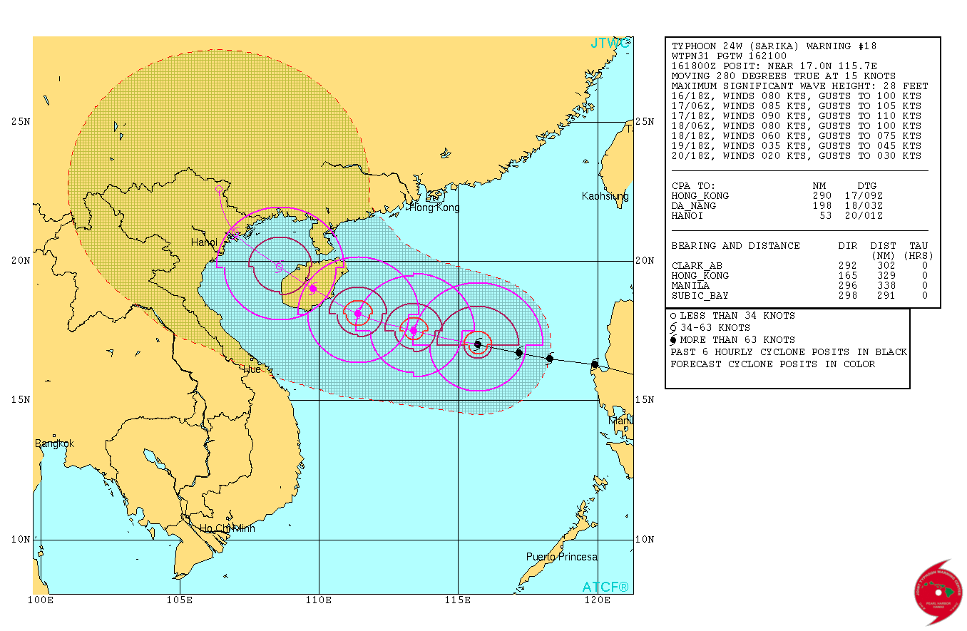
Typhoon "Sarika" forecast track by JTWC at 21:00 UTC on October 16, 2016
Sarika is expected to gain some modest strength over the next 24 to 30 hours prior to landfall on Hainan Island, China.
After that, Sarika is expected to make the final landfall in extreme northern Vietnam. This country has already suffered extreme flooding over the past couple of days, with at least 25 people killed and 4 missing, the government said Sunday.
Deputy Prime Minister Trinh Dinh Dung urged authorities in 22 coastal provinces to reinforce key infrastructure projects and prepare evacuation plans.
Many reservoirs are nearly full now and could burst at any time, state-run VTV warned viewers.
In the meantime, a new weather disturbance in the West Pacific has intensified into Typhoon "Haima". This new system is projected to make landfall in North Luzon late next week, potentially as a super typhoon.
Commenting rules and guidelines
We value the thoughts and opinions of our readers and welcome healthy discussions on our website. In order to maintain a respectful and positive community, we ask that all commenters follow these rules.