
Life-threatening Hurricane “Matthew” to hit Jamaica, Haiti, Cuba and the Bahamas
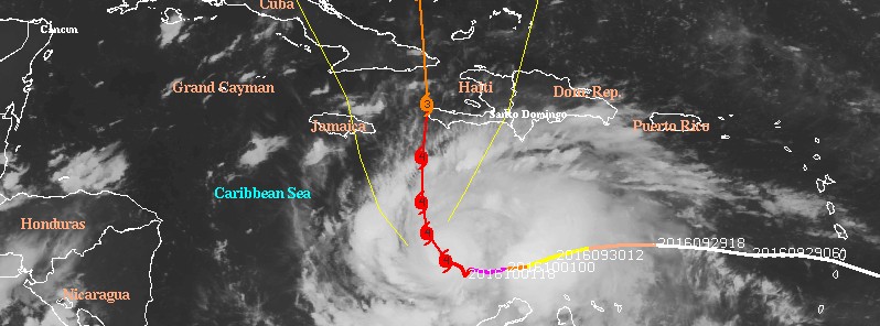
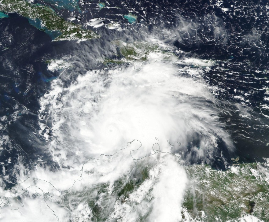
Featured image: Hurricane "Matthew" at 08:45 UTC on October 2, 2016. Credit: UW-CIMSS
Category 4 Hurricane "Matthew" is expected to approach southwestern Haiti and Jamaica during the UTC afternoon of Monday, October 3, 2016.
Matthew is bringing extremely heavy rain, very powerful winds and a combination of dangerous storm surge and high waves first to Jamaica, Haiti and Cuba and then to the Bahamas during the early UTC hours of Wednesday, October 5.
Preparations to protect life and property should be rushed to completion.
The current NHC forecast track (09:00 UTC, October 2) takes Matthew's eye right over or just west of the western tip of Haiti around 06:00 UTC on Tuesday, October 4. A direct hit to eastern Cuba is expected a couple of hours later.
Matthew is expected to produce total rain accumulations of 381 to 635 mm (15 to 25 inches) over southern Haiti, with possible isolated maximum amounts of 1 016 mm (40 inches).
254 to 508 mm (10 to 20 inches) are expected over eastern Jamaica, the Dominican Republic and eastern Cuba, with possible isolated maximum amounts of 635 mm (25 inches).
This rainfall will produce life-threatening flash floods and mudslides.
At 09:00 UTC on October 2, 2016, the center of Hurricane "Matthew" was located about 540 km (335 miles) SSE of Kingston, Jamaica and 540 km (345 miles) SSW of Port Au Prince, Haiti.
Matthew is moving slowly to the NW at 7 km/h (5 mph) and this motion is expected to continue until it turns north, toward Jamaica, Haiti and Cuba in the hours ahead.
Matthew is now a Category 4 hurricane on the Saffir-Simpson Hurricane Wind Scale with maximum sustained winds of 240 km/h (150 mph) and gusts up to 296 km/h (184 mph).
Some fluctuations in intensity are possible during the next couple of days, but Matthew is expected to remain a powerful hurricane.
Its minimum estimated central pressure is 940 hPa, according to the NHC.
Hurricane-force winds extend outward up to 35 km (25 miles) from the center, and tropical-storm-force winds extend outward up to 335 km (205 miles).
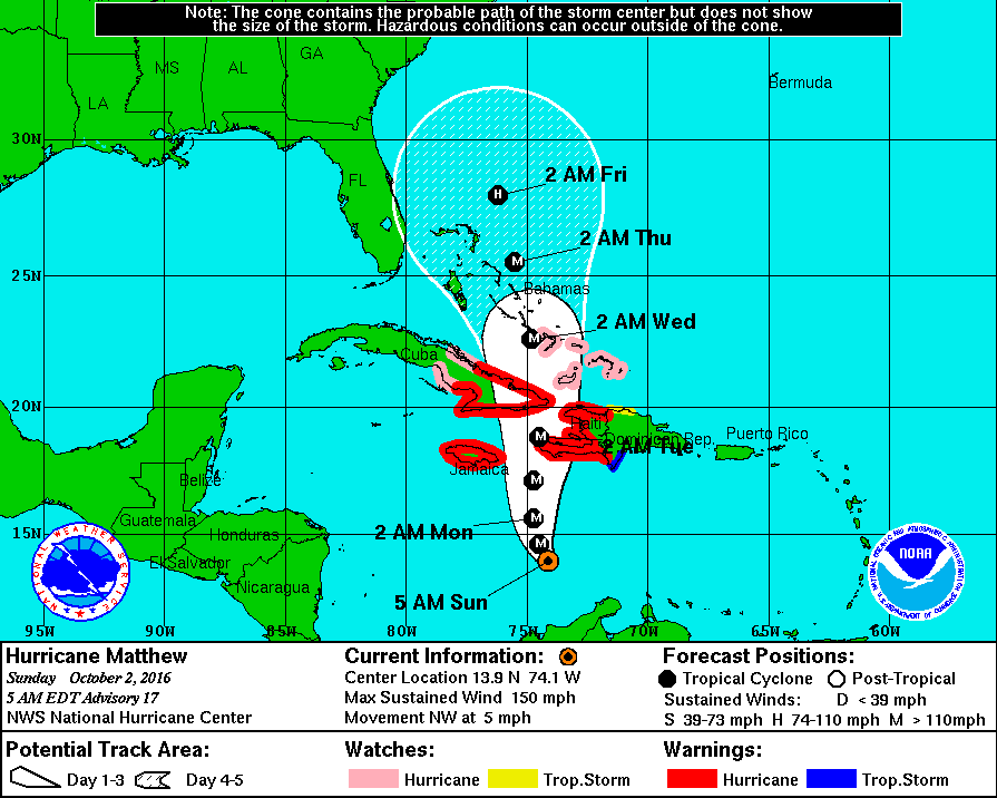
Hurricane "Matthew" forecast track by NHC at 09:00 UTC on October 2, 2016
Preparations to protect life and property should be rushed to completion as first effects will be felt within a couple of hours in Jamaica and Haiti, followed by eastern Cuba by Monday, October 3.
- A Hurricane Warning is in effect for Jamaica, Haiti, Cuban provinces of Guantanamo, Santiago de Cuba, Holguin, Granma, and Las Tunas
- A Hurricane Watch is in effect for Cuban province of Camaguey, Southeastern Bahamas, including the Inaguas, Mayaguana, Acklins, Crooked Island, and Long Cay, and Turks and Caicos Islands.
- A Tropical Storm Warning is in effect for the Dominican Republic from Barahona westward to the border with Haiti.
- A Tropical Storm Watch is in effect for the Dominican Republic from Puerto Plata westward to the border with Haiti.
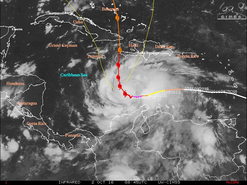
Hurricane "Matthew" IR image at 08:45 UTC on October 2, 2016 with NHC forecast track issued 06:00 UTC. Credit: UW-CIMSS
Life-threatening flash floods and mudslides
NHC expects Matthew will produce total rain accumulations of 381 to 635 mm (15 to 25 inches) over southern Haiti, with possible isolated maximum amounts of 1 016 mm (40 inches).
Total rain accumulations of 254 to 508 mm (10 to 20 inches) are expected over eastern Jamaica, the Dominican Republic and eastern Cuba, with possible isolated maximum amounts of 635 mm (25 inches).
This rainfall will produce life-threatening flash floods and mudslides.
Matthew is expected to produce additional rain accumulations of 25.4 to 50.8 mm (1 to 2 inches) over Aruba, Curacao, and Bonaire through today.
Total rain accumulations of 50.8 to 101.6 mm (2 to 4 inches) are expected over northern Colombia, northwest Venezuela, and western Jamaica, with possible isolated maximum amounts of 152.4 mm (6 inches).
Image below shows total accumulated rainfall over the past 72 hours (by 03:00 UTC on October 2, 2016):
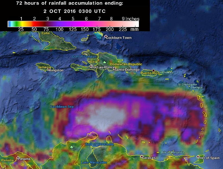
Hurricane "Matthew" – 72 hours of rainfall accumulation by 03:00 UTC on October 2, 2016. Credit: NASA/TRMM
Hurricane "Matthew" on October 1, 2016. Credit: NASA/NOAA/DoD Suomi NPP/VIIRS
Storm surge
The combination of a dangerous storm surge and large and destructive waves could raise water levels by as much as the following amounts above normal tide levels:
- Southern Coast of Cuba east of Cabo Cruz: 2.1 to 3.3 m (7 to 11 feet)
- South Coast of Haiti: 1.8 to 2.7 m (6 to 9 feet)
- Northern Coast of Cuba east of Camaguey: 1.2 to 1.8 m (4 to 6 feet)
- Jamaica: 90 cm – 1.5 m (3 to 5 feet)
- Gulf of Gonave in Haiti: 90 cm – 1.5 m (3 to 5 feet)
Surge-related flooding depends on the relative timing of the surge and the tidal cycle, and can vary greatly over short distances.
Large waves generated by Matthew will cause water rises to occur well in advance of and well away from the track of the center.
Surf
Swells generated by Matthew will continue to affect portions of the coasts of Puerto Rico, Hispaniola, Jamaica, Aruba, Bonaire, Curacao, Venezuela, Colombia, eastern Cuba, and the Caribbean coastline of Central America during the next few days.
These swells are likely to cause life-threatening surf and rip current conditions.
Hurricane "Matthew" – long-term track analysis
by meteorologist Lewi Cowan of the TropicalTidbits
Video courtesy Lewi Cowan, TropicalTidbits.com
Read more: Hurricane "Matthew" summary: data, images and videos – September/October 2016
The Watchers team and our contributors bring the latest on extreme weather, earthquakes, volcanic eruptions, space weather, and all things science. We're all about making sense of the natural world and keeping you informed on what’s happening. Got a tip or a question? Hit us up using the form at newstips!
Commenting rules and guidelines
We value the thoughts and opinions of our readers and welcome healthy discussions on our website. In order to maintain a respectful and positive community, we ask that all commenters follow these rules.