
Perfect storm creates weather events never seen before in South Australia
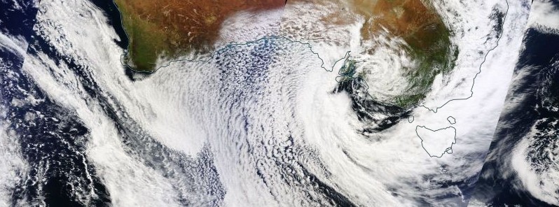
Image credit: NASA Terra/MODIS. Acquired: September 29, 2016
A deep low pressure system hit parts of the southeast Australia on Wednesday, September 28, unleashing widespread heavy rainfall and unprecedented winds to South Australia, New South Wales, Victoria, and Tasmania.
A line of severe storms first marched into South Australia during the early morning UTC hours of September 28 (afternoon local time) bringing heavy rain and winds of up to 120 km/h / 74.5 mph (some of the strongest winds the state has ever seen). In a short period, the storm produced more than 100 000 lightning strikes and several confirmed tornadoes. Shortly after, the entire South Australia and its 1.7 million residents were left without power.
Federal Environment and Energy Minister Josh Frydenberg said the preliminary observations were that a "perfect storm" of events – including electricity transmission towers blowing over and a lightning strike at a power station – combined to cause a debilitating surge at a crucial interconnector with Victoria that supplies a fifth of South Australia's energy.
Later on, Premier Jay Weatherill said in a press conference that two tornadoes destroyed three elements of critical infrastructure, which led to the power system protecting itself with a shutdown.
The blackout immediately caused chaos throughout the state with devastating effects, but some say this could have been expected since the closure of a gas power station at Port Augusta in May. At the time, Australian Energy Counciafinvl chief executive Matthew Warren said the power station's closure meant the state would have less back-up energy available on days of peak demand.
As of early September 30, some 20 000 residents were still without power.
Premier Weatherill described the storm as "catastrophic" and said it had involved weather events not seen before in the state.
"It's unusual for it to be organized and this well developed in Australia," said Rob Sharp, a meteorologist with Weatherzone. "It wraps all the way around with the associated cold front and the trough that continues up into Queensland. We often see cut-off low pressure systems but it's rare for them to be as slow moving as this one and as powerful as this one."
"South Australia had suffered the double-whammy of a summer-like thunderstorm on Wednesday, and then a winter-like storm on Thursday with cold temperatures and huge winds," Sharp said.
BOM – Severe Weather Update for September 29, 2016
A feed of moist tropical air coming in from the Indian Ocean down over South Australia and a very cold dry air moving up from the Southern Ocean over the top of that low have combined to lead to an environment that was right for the low to develop quite rapidly and also for severe thunderstorms to develop, BOM reported at 02:00 UTC on September 30 (12:00 AEST).
In the last 12 hours the system has been near stationary just over Victoria but was still wrapping in wind and moisture on its northern and southern flanks.
Mount Lofty Ranges in South Australia received between 100 and 120 mm (3.9 – 4.7 inches) of rain, Ovens and Kiewa catchments of Victoria between 80 and 100 mm (3.1 – 3.9 inches),Tasmania 50 and 100 mm (1.9 – 3.9 inches), NSW and ACT between 40 and 60 mm (1.5 – 2.3 inches).
The last couple of months have been the wettest in history for parts of southeast Australia so this additional rainfall fell on already heavily soaked grounds. As of 02:00 UTC today, there are 43 flood warnings in place across the southeast.
Most noticeably, a major flood warning is in place for the Gawler catchment in South Australia which is expected to peak later today. 73 mm (2.87 inches) of rain has been recorded within 36 hours within the catchment areas.
WATCH: There have been concerns throughout the afternoon for properties at Gawler. @alicemonfries reports. #9News https://t.co/lCD7ZlaziG
— Nine News Adelaide (@9NewsAdel) September 30, 2016
As of 05:58 UTC (15:28 CST), minor to major flooding is occurring in the North Para River and the Gawler River. The river level at Gawler Township is approaching the peak.
Levels in the Gawler River downstream of Gawler will rise during Friday afternoon to Friday night (local time) with moderate flooding expected.
The river levels in the North Para River upstream of Turretfield Dam have peaked and are receding.
The South Para Reservoir is full and is spilling. Water levels at the reservoir have reached a peak and will gradually fall over the weekend.
Major flooding in the Gawler River is occurring along the Gawler Township.
The Gawler River at Gawler West is currently at 7.59 m (24.9 feet) and rising but levels are now approaching the peak. The Gawler River at Gawler West will remain above the major flood level (7.30 m / 23.9 feet) during Friday afternoon.
The Gawler River at Heaslip Road is expected to exceed the moderate flood level (7.00 m / 22.9 feet) Friday afternoon. The river level is expected to peak around 22:00 local time with moderate flooding.
The River Gawler is likely to break out of the channel around Old Port Wakefield Rd to the Virginia bypass. Breakouts are also possible from Baker Rd to Old Port Wakefield Rd.
BOM – Severe Weather Update for September 30, 2016
This low pressure system is going to remain quite slow moving towards the southeast later today.
"The winds are starting to ease off as it moves away so our focus now shifts to the next system which is going to impact Western Australia during Saturday, October 1.
BOM expects gale force winds feeding in around this low once again, possibly impacting the Perth region. The system is going to continue to move toward the east across the weekend and is going to bring more rainfall which may lead to prolonged river rises in those already saturated eastern catchments, but not as much rainfall as experienced this week.
The Watchers team and our contributors bring the latest on extreme weather, earthquakes, volcanic eruptions, space weather, and all things science. We're all about making sense of the natural world and keeping you informed on what’s happening. Got a tip or a question? Hit us up using the form at newstips!
Commenting rules and guidelines
We value the thoughts and opinions of our readers and welcome healthy discussions on our website. In order to maintain a respectful and positive community, we ask that all commenters follow these rules.