
Record rain, wild electrical storms hit southeast Australia
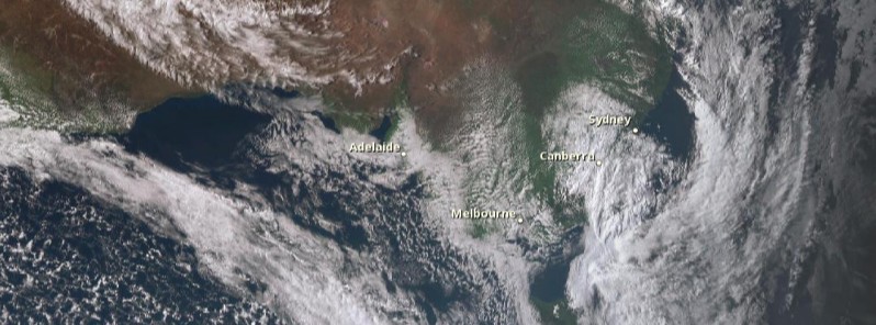
Image credit: JMA/Himawari acquired September 10, 2016
A strong cold front moved through southeast Australia on September 8 and 9, 2016, producing severe thunderstorms, very heavy rain, and powerful winds. Some regions experienced the heaviest rain in six years. The worst of the storms are over now, but the Australian Bureau of Meteorology warns some parts of the southeast will see more severe weather through the weekend and over the next week.
Severe thunderstorms in South Australia have cut power to thousands of people over the past two days. At the height of the storms, about 10 000 properties have lost power, most of them on the Eyre Peninsula. In some parts of the state, properties were without electricity and phone services for more than 24 hours after transmission lines were damaged.
Adelaide saw more than 19 000 lightning strikes on September 8 and about 30 mm (1.18 inches) of rain was reported in its eastern suburbs in just 30 minutes, making September 8 Adelaide's wettest September day in six years.
Flash flooding covered most of the city and emergency services said they reacted to more than 150 calls for help overnight. One car was hit by a lightning while driving in Adelaide's southern suburb. The driver was taken to the hospital in stable condition.
Don't let the weather put a dampener on #FinalsFever! Prepare your game plan with https://t.co/4W35o8zIoh @AFL @NRL pic.twitter.com/aGKLrv8ty4
— BOM Australia (@BOM_au) September 9, 2016
Strong cold front moving across the SE today. More fronts expected over weekend & next week. https://t.co/jlOoTZL1iF pic.twitter.com/TKDBrLA98W
— BOM Australia (@BOM_au) September 9, 2016
Meteorologist Stevie Jones said what they saw there was tropical moisture feeding into two cold fronts moving through Western Australia earlier in the week, causing some damage, and then over South Australia on Thursday and Friday (September 8 and 9) and into western Victoria, New South Wales, and Tasmania.
Victoria was set to get hit by pretty hard, with a month worth of rain in just one day. This has also been exacerbated by above average sea temperatures over the east coast of Australia, feeding moisture over Australia and making these rain events even heavier.
"The heavy rain came at a very bad timing because the river catchments are full at the moment with the amount of rain they received over winter," Jones said.
"New South Wales had its third wettest winter on record, South Australia its wettest winter in 15 years and areas of northern Tasmania had wettest 4 months ever on record. The catchments are full, the ground is saturated with water which makes this a very bad timing for such heavy rain."
Keep up to date with warnings, especially flooding over eastern Aust after recent rain https://t.co/wdUcA3jLa8 pic.twitter.com/WP1XdYsHxM
— BOM Australia (@BOM_au) September 9, 2016
Current weather warnings
as of 10:15 UTC on September 10, 2016 / 18:15 AWST / 19:45 ACST / 20:15 AEST
Western Australia
Queensland
- Severe Thunderstorm Warning – Southeast Queensland (QLD),
- Minor Flood Warning for the Paroo River,
- Final Flood Warning for the Lower Bulloo River,
- Minor Flood Warning for the Diamantina River,
- Flood Warning Summary for Queensland.
NSW and ACT
- Marine Wind Warning Summary for New South Wales,
- Warning to Sheep Graziers for Central Tablelands, Southern Tablelands, Central West Slopes & Plains, South West Slopes, Riverina and Snowy Mountains forecast districts,
- Flood Watch – New South Wales (NSW),
- Flood Warning – Gwydir River (NSW),
- Flood Warning – Peel and Namoi Rivers (NSW),
- Flood Warning – Macquarie River NSW (NSW),
- Flood Warning – Bogan River (NSW),
- Flood Warning – Lachlan River (NSW),
- Flood Warning – Murrumbidgee River (NSW),
- Flood Warning – Murray River (NSW),
- Flood Warning – Warrego River (NSW),
- Flood Warning – Paroo River (NSW),
- Flood Warning – Belubula River (NSW),
- Flood Warning – Murray River Upstream of Lake Hume (VIC).
Victoria
- Flood Warning – Murray River (NSW),
- Severe Weather Warning 2 (VIC),
- Marine Wind Warning Summary for Victoria,
- Flood Watch – North East Victoria (VIC),
- Flood Watch – Goulburn and Broken Rivers (VIC),
- Flood Warning Summary (VIC),
- Flood Warning – Werribee River (VIC),
- Flood Warning – Glenelg River (VIC),
- Flood Warning – Kiewa River (VIC),
- Flood Warning – Ovens and King Rivers (VIC),
- Flood Warning – Broken River (VIC),
- Flood Warning – Seven Creeks and Castle Creek (VIC),
- Flood Warning – Campaspe River (VIC),
- Flood Warning – Loddon River (VIC),
- Flood Warning – Avoca River (VIC),
- Flood Warning – Murray River Upstream of Lake Hume (VIC).
Tasmania
The Watchers team and our contributors bring the latest on extreme weather, earthquakes, volcanic eruptions, space weather, and all things science. We're all about making sense of the natural world and keeping you informed on what’s happening. Got a tip or a question? Hit us up using the form at newstips!
This is weather manipulation and I can see it from satellite pictures !!!!
http://www.geoengineeringwatch.org/