
2015 El Nino: Ocean temperatures in the tropical Pacific rising
Featured image: 7-day sea surface temperature (June 1 - 7, 2015). Credit: NOAA/NCDC/NNVL
The Australian Bureau of Meteorology analysis of international climate models indicates further warming of the tropical Pacific. The sea surface temperatures are forecasted to remain above the El Niño threshold for the rest of this year which means the 2015 El Nino is continually developing.
The sea surface temperatures in the tropical Pacific have continued to rise, and trade winds are constantly weaker than on average. Due to current local climate conditions, the El Niño Southern Oscillation Index (SOI) is on the rise, with values averaging on -9.7, exceeding the thresholds.
El Niño is related to a band of warm ocean water mass which forms in the central and east-central equatorial Pacific. It is a warm phase of the El Niño Southern Oscillation (ENSO). ENSO cycle is an exchange of hot and cold sea surface temperatures (SST) in the tropical central and eastern Pacific. The cold phase of the oscillation is called La Nina and the warm phase is El Niño. Both El Niño and La Niña cause global changes to temperatures and rainfall.

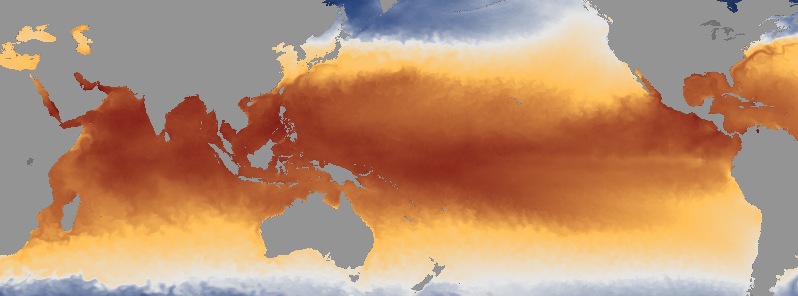
Image credit: BOM
The SST anomaly map for May 2015 (above) shows positive anomalies across the equatorial Pacific extending from the South American coastline past the International Date Line to around 160°E. Temperatures of the northeast Pacific Ocean steadily remain above average, while the temperatures around Australia cooled down in comparison to April SST values. The May anomalies in the Australian region remained close to average. According to the data, all NINO indices averaged per month were greater than +1 °C, which was not the case since the El Niño of 1997-98.
The value of Indian Ocean Dipole (IOD), which can be related to reduced winter and spring rainfall over parts of southern and central Australia is neutral at the minute. Two international models indicate IOD values to be positive later in 2015 while third model suggest values only a shy above the thresholds. A positive IOD values indicate reduced winter and spring rainfall over parts of southern and central Australia.
Typically El Niño is indicated with delays in monsoon onset, and this season's monsoon arrival was running approximately five days behind the schedule. The convection over the central equatorial Pacific was also above the average last week in consistency with current El Niño development.
After a quiet period in April and most of May, the Madden—Julian Oscillation (MJO) strengthened over Africa and the Indian Ocean. According to majority of the models, the MJO signal may act to enhance tropical activity over the Indian Ocean, but it's influence on tropical weather should reduce after a week.
I believe it is due to undersea volcanic eruptions – assuming the record number of erupting volcanoes on land as pretty good indicator or what we don’t underwater.
Anyone read about a nuclear power plant that went belly up about 5 years ago? Maybe that is the reason.