
2015 El Niño event strongest since 1997–98
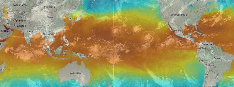
Featured image: Sea surface temperatures with global infrared image for September 1, 2015. Credit: UW-CIMSS.
Australian Bureau of Meteorology (BOM) issued its latest analysis and the status of the 2015 El Niño today, confirming it is the strongest El Niño since 1997-98.
The tropical Pacific Ocean and atmosphere are fully coupled, with sea surface temperatures well above El Niño thresholds, consistently weak trade winds, and a strongly negative Southern Oscillation Index, BOM reports.
Weekly tropical Pacific Ocean temperature anomalies (i.e. difference from normal) in the central Pacific are now at their highest values since 1997–98, though still remain more than half a degree below the peak observed during 1997–98.
Most international climate models surveyed by the Bureau indicate the tropical Pacific will continue to warm, with the largest anomalies occurring later in the year.
While the Indian Ocean as a whole has been at near-record temperatures, the Indian Ocean Dipole (IOD) index has been at or above +0.4 °C for the past four weeks.
To be considered a positive event, the IOD would need to remain at or above +0.4 °C through September.
The 2015 event has, so far, been following a normal El Niño life cycle.
Source: BOM
For more information, please visit:
- ENSO Wrap-Up – Current state of the Pacific and Indian Ocean (BOM)
- El Niño/Southern Oscillation (ENSO) Diagnostic Discussion (NWS/CPC)
The Watchers team and our contributors bring the latest on extreme weather, earthquakes, volcanic eruptions, space weather, and all things science. We're all about making sense of the natural world and keeping you informed on what’s happening. Got a tip or a question? Hit us up using the form at newstips!
Commenting rules and guidelines
We value the thoughts and opinions of our readers and welcome healthy discussions on our website. In order to maintain a respectful and positive community, we ask that all commenters follow these rules.