
Massive M8.1 earthquake hits Nepal, over 8 000 fatalities – Report and updates
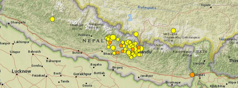
Image credit: USGS
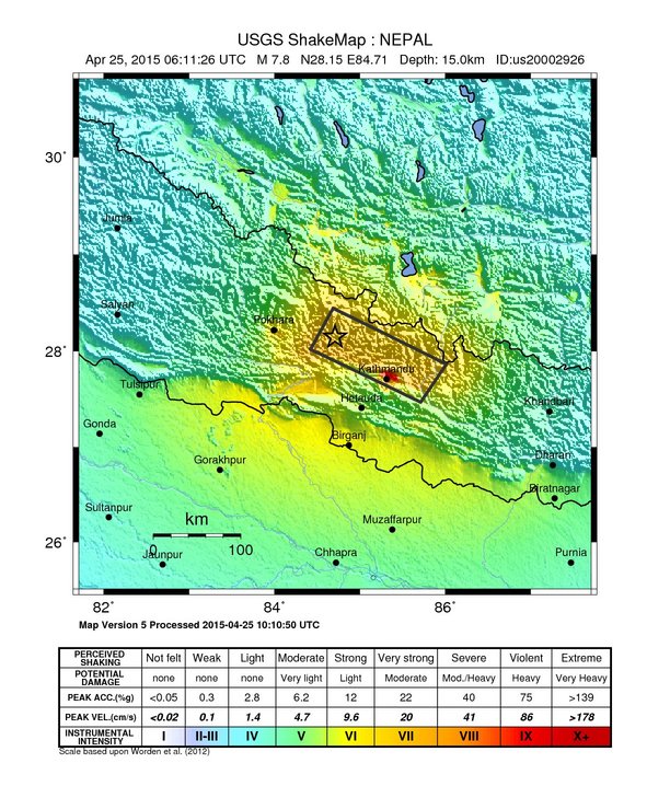
A very strong and shallow earthquake registered as M8.1 (CENC) hit Nepal at 06:11 UTC on April 25, 2015. CENC (China) is reporting depth of 20 km (12.4 miles). USGS is reporting M7.8 at a depth of 15.0 km (9.3 miles).
According to the USGS, epicenter was located about 35 km (22 miles) E of Lamjung, 60 km (37 miles) NNE of Bharatpur, 75 km (47 miles) E of Pokhara, 76 km (47 miles) NW of Kirtipur and 77 km (48 miles) NW of capital Kathmandu, Nepal.
There are about 6 667 822 people living within 100 km radius.
USGS issued red alert for shaking-related fatalities and economic losses. High casualties and extensive damage are probable and the disaster is likely widespread. Past red alerts have required a national or international response.
Overall, the population in this region resides in structures that are highly vulnerable to earthquake shaking, though some resistant structures exist. The predominant vulnerable building types are unreinforced brick masonry and rubble/field stone masonry construction.
Recent earthquakes in this area have caused secondary hazards such as landslides and liquefaction that might have contributed to losses.
A lot of devastation is expected, as well as strong and damaging aftershocks and large landslides.
Tremors were felt as far away as New Delhi and other northern cities in India.
According to media reports, massive tremors from initial earthquake lasted well over a minute.
This was the biggest quake in Nepal since the "1934 Nepal-Bihar earthquake" which severely damaged Kathmandu, and is thought to have caused around 10 600 fatalities. It is now reffered to as the "Gorkha earthquake".
Updates
07:30 UTC: Huge damage and collapsed houses are reported in Pokahara and capital Kathmandu. The first fatalities are reported originating from collapsed homes.
Cell phone service is paralyzed throughout Nepal.
Powerful aftershocks are hitting the region. EMSC is reporting M5.5 at 06:38 UTC at a depth of 100 km; M6.7 at 06:45 UTC at a shallow depth of 10 km, CENC is reporting this aftershock as M7.0 at a depth of 30 km; M5.8 at 06:56 UTC at a depth of 114 km; M5.3 at 07:08 UTC at a depth of 100 km. See updated aftershocks list below.
Dr. James Daniel has put all data in his theoretical model and expects in between 1 400 and 7 500 fatalities (ER).
EMSC "I felt it report" from reader in Kathmandu: "It is really big shaking all over. I never feel this kind of shake before!!"
At 07:52 UTC, ER reported official death count is 5 in Nepal and 1 in India (these are the first numbers).
There are reports that the quakes have triggered avalanches in Mount Everest region. Base camp of mountaineers is also reported to have been hit. Many mountaineers are reported to be missing .
Kathmandu airport has been shut post the earthquake and all flights diverted to India.
Nepal’s Lamjung, the epicenter of the quake, has reportedly flattened and only few buildings there are believed to be standing.
Historic Dharahara Tower in Kathmandu, built in 1832, has collapsed. This tower had been open to visitors for the last 10 years and had a viewing balcony on its eighth floor. One body was removed from the tower and a second lay further up the road, the witness said. It was not immediately clear how many people were in the multi-storey tower when it collapsed, DNA India reports. Nepali media reports that around 50 people are trapped in the rubble of the collapsed tower, and not 400 as reported earlier. Update: 180 bodies were retrieved from debris of Dharhara tower, as per reports received by 17:54 UTC.
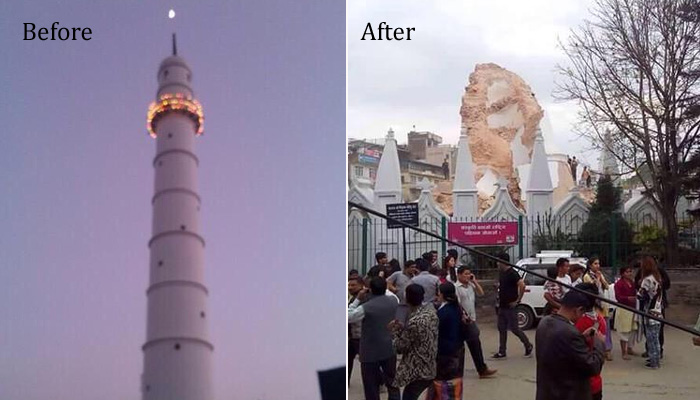
Image courtesy @StefSimanowitz (via Twitter)
Many historic temples have also been reduced to rubble in Nepal.
At 08:38 UTC, ER reports 30 people have been killed in Nepal, 3 people in Bihar, India and 1 in Siliguri. This number will rise every hour. There are no news from the epicenter area yet.
Power has been switched off in North Bihar for safety reasons.
There are reports of collapsed houses in Tibet.
Nepal’s information minister has told BBC that there has been massive damage in Gorkha, Lamjung and Bhaktapur.
ER update at 09:29 UTC: At least 150 people killed in Kathmandu, 1 in China, 10 in Pokhara, 2 at Mount Everest Base Camp and 11 in India (2 caused by mass panic)
10:24 UTC: The death toll in Nepal alone has climbed to 202 without 1 person from the direct epicenter area!
12:06 UTC: The earthquake toll is further climbing in Nepal and India – 750 fatalities reported so far (711 Nepal, 7 China, 30 India and 2 Bangladesh).
15:19 UTC: Massive rise in death count, now at 1 508 and further rising (1 457 Nepal, 12 China, 36 India and 3 Bangladesh).
17:28 UTC: Late night in Nepal right now. Outside temperatures in Nepal 12 °C and colder in higher areas. People are or in the open or in shelters due to fear of strong aftershocks. (ER)
19:09 UTC: New fatalities update 1554 (1475 Nepal, 13 China, 62 India and 4 Bangladesh).
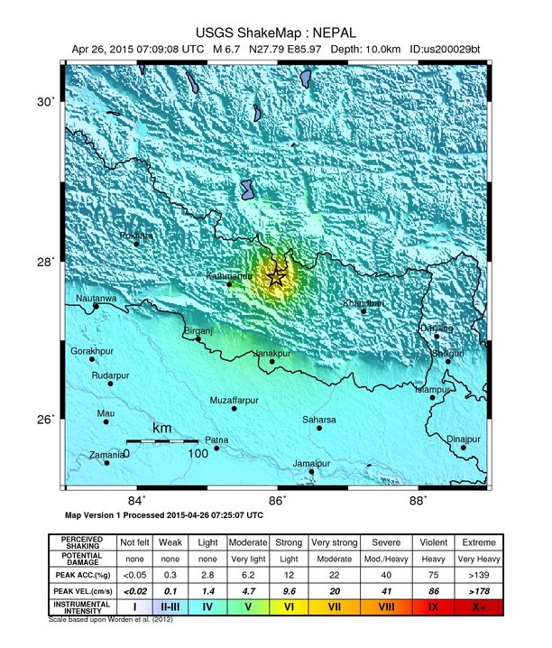
April 26, 2015:
07:09 UTC: Very strong aftershock measuring M6.7 (USGS) hits the region at a depth of 10 km. CENC (China) is reporting it as M7.1 at a depth of 10 km.
07:20 UTC: The current estimate of fatalities is at 1910 in Nepal, 13 in China, 62 in India and 4 in Bangladesh. A number of avalanches have caused large fatalities including the Mt. Qomolangma one with 17 killed, 61 injured.
07:45 UTC: Based on preliminary estimates from CATDAT, the direct losses in the earthquake are around the 3-3.5 billion USD and around 5-5.5 billion USD replacement/reconstruction costs from the theoretical model, using updated damage data. We hope that at least 20% extra is spent on the reconstruction with better earthquake resistant housing and buildings being built than simply the replacement costs! This is a significant loss financially, as well as the terrible human toll for Nepal – being in the order of 15-20% of GDP for the loss, and the reconstruction needing over 25%. It is important to note, that these values do not include indirect losses (usually an extra 50% for a country like Nepal) and intangible effects (cost to families, culture, religion etc.). (ER)
09:36 UTC: Fatality update: 2 092 (2 000 Nepal, 18 China, 70 India and 4 Bangladesh).
11:17 UTC: Fatality update: 2 244 (2 152 Nepal, 18 China, 70 India and 4 Bangladesh).
17:33 UTC: The Nepal earthquake is at this moment the 10th deadliest earthquake of the 21th century. (ER)
19:43 UTC: Fatality update: 2 589 (2 500 Nepal, 20 China, 68 India and 4 Bangladesh).
19:52 UTC: 217 people are missing in Mount Everest region, according to ministry officials. Twenty-two bodies have been recovered from the quake triggered avalanche site in the Mount Everest base camp.
April 27, 2015:
07:20 UTC: Fatality update: 3 443 (3 351 Nepal, 20 China, 68 India and 4 Bangladesh) – Injured in Nepal: 6 833
08:07 UTC: Fatality update: 3 709 (3 617 Nepal, 20 China, 68 India and 4 Bangladesh).
11:28 UTC: Fatality update: 3 824 (3733 Nepal, 20 China, 68 India and 4 Bangladesh) – Injured in Nepal: 7 002
18:42 UTC: Fatality update: 4 365 (4 264 Nepal, 25 China, 72 India and 4 Bangladesh) – Injured in Nepal: 7002
18:49 UTC: Drone footage recorded over the Nepalese capital Kathmandu shows the scale of destruction following a major earthquake.
April 28, 2015:
07:18 UTC: Nepal's prime minister, Sushil Koirala, has warned that the number killed in the earthquake could more than double to 10,000 people. He also ordered ordered rescue efforts to be stepped up and appealed for foreign supplies of tents and medicines.
07:44 UTC: Important note from Armand Vervaeck, the founder of Earthquake-report.com (ER):
Reuters quotes the Country’s Prime Minister Sushil Koirala as he said that “fatalities could reach 10,000″. Prudence should be on it’s place for these words.
At the time of writing this update (07:44 UTC) the death toll stands at 4,450 people and will keep increasing for a while. Less than 1000 of the total number are pointing to Kathmandu, almost the sole area where the media is reporting from. The fatality statistics (which we have seen yesterday evening) point however to an adequate repartition where the hardest hit areas are having the biggest fatality numbers. Some villages are still unaccounted for but the districts are already present in the fatality numbers.
Why inflation fear? Poor Nepal gets now the empathy of the world and will need billions of dollars (5 to 10 billion) to rebuild housing and infrastructure. Based on the Haiti example we know that fatality statistics were greatly inflated to get more empathy and more money from the international community.
Telling the press a number more than double than the current number is not wise.
Telling the press that Nepal needs billions of dollars of support would have been better.
09:50 UTC: Fatality update: 4 450 (4 349 Nepal, 25 China, 72 India and 4 Bangladesh) – Injured in Nepal: 8 517.
12:43 UTC: Some 250 people are missing after an avalanche in Rasuwa, a trekking area north of Kathmundu.
12:54 UTC: Fatality update: 5 158 (5 057 Nepal, 25 China, 72 India and 4 Bangladesh) – Injured in Nepal : 10 915. A lot of small villages are still unaccounted for.
April 29, 2015:
14:30 UTC: Helicopters are reaching remote villages in the Gorkha district. A lot of damage to homes. Seriously injured people are taken to Kathmandu hospitals. Video is a snapshot of an Image Channel Television video.
15:00 UTC: Rescuers are still at work in Kathmandu as the sun sets on the third day after a deadly earthquake struck the country.
15:24 UTC: Scary video captured by a CCTV camera along Tundikhel, the parade ground of Kathmandu (ER)
17:08 UTC: Fatality update: 5 339 (5 238 Nepal, 25 China, 72 India and 4 Bangladesh) – Injured in Nepal: 10 348.
April 30, 2015:
06:55 UTC: Roads in Kathmandu almost back to normal. Almost usual traffic & public vehicles.
08:04 UTC: Walking through devastated Kathmandu
10:33 UTC: Fatality update: 5 590 (5 489 Nepal, 25 China, 72 India and 4 Bangladesh) – Injured in Nepal: 10 965.
11:31 UTC: Airbus Defence and Space has acquired Pléiades satellites imagery to support the International Charter (Space and Major Disasters) and the Copernicus Emergency Management Service. The data acquired will assist in assessing the damage and help rescue organisations in the delivery of humanitarian aid:
15:50 UTC: Fatality update: 5 945 (5 844 Nepal, 25 China, 72 India and 4 Bangladesh) – Injured in Nepal: 10 965.
20:53 UTC: Fatality update: 6 256 (6 155 Nepal, 25 China, 72 India and 4 Bangladesh) – Injured in Nepal: 13 402. (ER)
Situation overview by UNOCHA
Six days into the response, the ongoing relief efforts continue to focus on reaching a greater number of areas, in particular the remote and hard-to-reach areas where many of the poorest and most affected remain.
It is becoming evident that a scale-up of operations is required to ensure immediate and principled assistance reaches people in desperate need within the next six weeks, in advance of the monsoon season. After the field visits and meetings with Government authorities and partners, the Emergency Relief Coordinator Valerie Amos emphasized the urgent need to provide emergency shelter and basic goods and services to people affected, as the weather conditions continue to deteriorate.
Following initial assessments, the Government has extended the most affected area to include Makawanpur and Sindhuli districts, in addition to Bhaktapur, Dhading, Dolakha, Gorkha, Kathmandu, Lalitpur, Lamjung, Rasuwa, Ramechhap, Nuwakot, and Sindulpalchowk.
The United Nations Disaster Assessment and Coordination (UNDAC) teams have traveled to Dhading and Gorkha, where the team has set-up a humanitarian hub for the area. On 2 May, another team is scheduled to arrive in Sindulpachowk District.
In Gorkha, the UNDAC team has found that there is a dire need for shelter, particularly tents and blankets. Access to some remote villages remains a key challenge as many landing zones are unsafe due to debris, altitude and current weather conditions. Road access is limited. Some remote villages can only be accessed by helicopters.
$415 million need for vital humanitarian relief
160 786 destroyed houses
143 673 damaged houses
May 2, 2015:
12:45 UTC: Fatality update: 6 723 (6 621 Nepal, 26 China, 72 India and 4 Bangladesh) – Injured in Nepal: 14 021.
May 5, 2015:
06:44 UTC: Fatality upate: 7 467 (7 365 Nepal, 26 China, 72 India and 4 Bangladesh) – Injured in Nepal: 18 261.
May 9, 2015:
Drone video of life and damage in the Kathmandu valley:
Fatality update: 8 014 (7 912 Nepal, 26 China, 72 India and 4 Bangladesh) – Injured in Nepal: 17 804.
May 12, 2015:
Fatality update: 8 148 (8 046 Nepal, 26 China, 72 India and 4 Bangladesh) – Injured in Nepal: 17 804.
Massive aftershock measuring M7.5 by CENC (M7.3 by USGS) hits the region at 07:05 UTC. Reports collected by 10:45 UTC mention 16 casualties in Nepal and 4 in India.
.jpg)
This page will be updated.
For detailed updates, please visit our friends at Earthquake-report.com
Multimedia
CCTV camera at a border inspection station in Gyirong, Tibet Autonomous Region, captures the moment the 7.9-magnitude earthquake struck Nepal:
The CCTV footage below was recorded in India. Unfortunately, it does not say exactly where in India.
Siobhan Heanue, ABC News Australia correspondent, was in Kathmandu when the devastating earthquake struck. In the video below, she tells Reported.ly's Malachy Browne what she saw:
Scottish geologist Iain Stewart explains in 17 minutes the many elements of the Gorkha earthquake.
#NepalEarthquake: Another hard-hit village #Laprak at #Gorkha. No support reached yet. Praying! (Pic @brb_laaldhwoj) pic.twitter.com/S6uycmAavN
— Gundruk Post (@GundrukPost) April 26, 2015
OMG….Here's what a village in Gorkha that was near the epicenter of #NepalEarthquake looks like(via Ujyaalo Online) pic.twitter.com/4lrskdDhga
— Oxomiya Jiyori (@SouleFacts) April 26, 2015
Left: #Kathmandu in 2014, already infrastructure nightmare. Right: after 7.9 quake. #Nepal will struggle to recover. pic.twitter.com/NedJMDwcXe
— Rebecca McKeown (@rebiccamck) April 25, 2015
RT zerohedge "RT cctvnews: Second quake at M7.0 jolts ground 30km beneath #Nepal at 6:45 UTC, 34 minutes after the… pic.twitter.com/jQb3oOaDf6"
— Jonathan (@jonnylaw59) April 25, 2015
Patan Durbar Square one of my favourite monuments, just can't believe this. #nepal pic.twitter.com/rheP6msRFn
— Naila Inayat (@nailainayat) April 25, 2015
Thinking of all those #Nepal Hoping for the best in wake of earthquakes pic.twitter.com/szHmsCxXrq
— Mark Hawthorne (@HawthorneMark) April 25, 2015
My Prayers with people of #Nepal & across #India after the massive 7.9 magnitude #Earthquake. Hope everyone is safe! pic.twitter.com/eQCP5fz5FC
— Habibies (@Habibies) April 25, 2015
Heavy tremors in #Nepal pic.twitter.com/svlmK8ujzv
— श्रीकान्त (@Ajnanahanta) April 25, 2015
Buildings collapse in #Kathmandu after M7.7 #earthquake hits #Nepal, casualties are feared pic.twitter.com/nKUAZ2asRM
— China Xinhua News (@XHNews) April 25, 2015
The remains of the day. #Kathmandu's Patan Durbar Square as it was & now is. #NepalEarthquake Photos via @cctvnews pic.twitter.com/3HUzHm6M8m
— Radha Kapoor Sharma (@radhakaps) April 25, 2015
Aftershocks
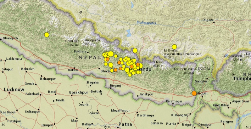
Image credit: USGS
- 4.32015-04-27 23:20:28 UTC10.0 km
- 4.32015-04-27 21:27:41 UTC10.0 km
- 3.92015-04-27 21:14:57 UTC10.0 km
- 4.82015-04-27 18:59:56 UTC20.0 km
- 4.52015-04-27 15:51:46 UTC10.0 km
- 4.12015-04-27 14:57:00 UTC10.0 km
- 5.12015-04-27 12:35:52 UTC29.4 km
- 4.22015-04-27 00:39:16 UTC10.0 km
- 4.62015-04-26 22:32:34 UTC10.0 km
- 4.42015-04-26 20:39:20 UTC10.0 km
- 4.22015-04-26 18:54:49 UTC10.0 km
- 5.32015-04-26 16:26:05 UTC10.0 km
- 4.42015-04-26 14:57:05 UTC17.6 km
- 4.62015-04-26 14:44:49 UTC10.0 km
- 4.52015-04-26 13:11:15 UTC10.0 km
- 4.52015-04-26 08:46:16 UTC10.0 km
- 4.62015-04-26 08:40:55 UTC10.0 km
- 4.72015-04-26 07:36:26 UTC10.0 km
- 5.02015-04-26 07:26:04 UTC10.0 km
- 6.72015-04-26 07:09:10 UTC17.3 km
- 4.42015-04-26 04:58:39 UTC10.0 km
- 4.62015-04-26 02:48:39 UTC10.0 km
- 4.52015-04-25 23:41:52 UTC10.0 km
- 5.62015-04-25 23:16:15 UTC10.0 km
- 4.32015-04-25 23:12:52 UTC10.0 km
- 4.72015-04-25 21:07:17 UTC10.0 km
- 4.42015-04-25 20:32:48 UTC10.0 km
- 4.12015-04-25 18:58:34 UTC10.0 km
- 5.42015-04-25 17:42:49 UTC3.2 km
- 4.92015-04-25 16:27:21 UTC10.0 km
- 4.62015-04-25 14:10:02 UTC10.0 km
- 4.62015-04-25 13:36:14 UTC10.0 km
- 4.62015-04-25 13:30:28 UTC10.0 km
- 5.22015-04-25 12:44:04 UTC10.0 km
- 4.52015-04-25 12:17:55 UTC10.0 km
- 4.22015-04-25 12:01:13 UTC10.0 km
- 4.42015-04-25 10:53:43 UTC10.0 km
- 4.82015-04-25 10:40:35 UTC10.0 km
- 4.22015-04-25 10:23:19 UTC10.0 km
- 5.02015-04-25 09:30:29 UTC10.0 km
- 5.72015-04-25 09:17:02 UTC10.0 km
- 4.92015-04-25 09:03:15 UTC10.0 km
- 5.32015-04-25 08:55:55 UTC10.0 km
- 4.42015-04-25 08:49:09 UTC10.0 km
- 5.02015-04-25 08:29:24 UTC10.0 km
- 4.72015-04-25 08:20:11 UTC10.0 km
- 4.92015-04-25 08:16:59 UTC10.0 km
- 4.62015-04-25 08:05:37 UTC10.0 km
- 5.02015-04-25 07:47:01 UTC10.0 km
- 4.52015-04-25 07:39:33 UTC10.0 km
- 4.82015-04-25 07:16:56 UTC10.0 km
- 4.82015-04-25 07:13:44 UTC10.0 km
- 5.02015-04-25 07:07:59 UTC10.0 km
- 5.52015-04-25 06:56:34 UTC10.0 km
- 6.62015-04-25 06:45:21 UTC14.6 km
- 5.12015-04-25 06:37:58 UTC9.8 km
- 7.82015-04-25 06:11:26 UTC15.0 km
- 5.02015-04-21 14:02:19 UTC41.8 km
USGS aftershock forecast for the Magnitude 7.8 Nepal earthquake of April 25, 2015
(as of April 27, 2015)
In the coming week, the USGS expects 3-14 M≥5 aftershocks of the magnitude 7.8 Nepal earthquake. Additionally, the USGS estimates that there is a 54% chance of a M≥6 aftershock, and a 7% chance of a M≥7 aftershock during this one-week period. After this, in the following month and then the following year, USGS expects several M≥5 aftershocks, with a significant chance of M≥6 aftershock (greater than 50%). The potential for an aftershock larger than the mainshock remains, but is small (1-2% in each time period).
Felt earthquakes (i.e., those with M≥ 3 or 4) will be common over the next weeks to months. Based on general earthquake statistics, the expected number of M≥ 3 or 4 aftershocks can be estimated by multiplying the expected number of M>=5 aftershocks by 100 or 10, respectively. The expected location of the aftershocks will be in the zone of current activity and at its edges. Currently aftershocks are occurring in a zone extending approximately 200 km away from the mainshock epicenter.
View and download Aftershock Forecast with Table and Background information
This information is preliminary and subject to change.
Tectonic summary
The April 25, 2015 M8.1 earthquake (M7.8 according to the USGS) occurred as the result of thrust faulting on or near the main frontal thrust between the subducting India plate and the overriding Eurasia plate to the north. At the location of this earthquake, approximately 80 km to the northeast of the Nepalese capital of Kathmandu, the India plate is converging with Eurasia at a rate of 45 mm/yr towards the north-northeast, driving the uplift of the Himalayan mountain range. The preliminary location, size and focal mechanism of the April 25 earthquake are consistent with its occurrence on the main subduction thrust interface between the India and Eurasia plates.
Although a major plate boundary with a history of large-to-great sized earthquakes, large earthquakes on the Himalayan thrust are rare in the documented historical era. Just four events of M6 or larger have occurred within 250 km of the April 25, 2015 earthquake over the past century. One, a M 6.9 earthquake in August 1988, 240 km to the southeast of the April 25 event, caused close to 1500 fatalities. The largest, an M 8.0 event known as the 1934 Nepal-Bihar earthquake, occurred in a similar location to the 1988 event. It severely damaged Kathmandu, and is thought to have caused around 10,600 fatalities.
Seismotectonics of the Himalaya and Vicinity
Seismicity in the Himalaya dominantly results from the continental collision of the India and Eurasia plates, which are converging at a relative rate of 40-50 mm/yr. Northward underthrusting of India beneath Eurasia generates numerous earthquakes and consequently makes this area one of the most seismically hazardous regions on Earth. The surface expression of the plate boundary is marked by the foothills of the north-south trending Sulaiman Range in the west, the Indo-Burmese Arc in the east and the east-west trending Himalaya Front in the north of India.
The India-Eurasia plate boundary is a diffuse boundary, which in the region near the north of India, lies within the limits of the Indus-Tsangpo (also called the Yarlung-Zangbo) Suture to the north and the Main Frontal Thrust to the south. The Indus-Tsangpo Suture Zone is located roughly 200 km north of the Himalaya Front and is defined by an exposed ophiolite chain along its southern margin. The narrow (<200km) Himalaya Front includes numerous east-west trending, parallel structures. This region has the highest rates of seismicity and largest earthquakes in the Himalaya region, caused mainly by movement on thrust faults. Examples of significant earthquakes, in this densely populated region, caused by reverse slip movement include the 1934 M8.1 Bihar, the 1905 M7.5 Kangra and the 2005 M7.6 Kashmir earthquakes. The latter two resulted in the highest death tolls for Himalaya earthquakes seen to date, together killing over 100,000 people and leaving millions homeless. The largest instrumentally recorded Himalaya earthquake occurred on 15th August 1950 in Assam, eastern India. This M8.6 right-lateral, strike-slip, earthquake was widely felt over a broad area of central Asia, causing extensive damage to villages in the epicentral region.
The Tibetan Plateau is situated north of the Himalaya, stretching approximately 1000km north-south and 2500km east-west, and is geologically and tectonically complex with several sutures which are hundreds of kilometer-long and generally trend east-west. The Tibetan Plateau is cut by a number of large (>1000km) east-west trending, left-lateral, strike-slip faults, including the long Kunlun, Haiyuan, and the Altyn Tagh. Right-lateral, strike-slip faults (comparable in size to the left-lateral faults), in this region include the Karakorum, Red River, and Sagaing. Secondary north-south trending normal faults also cut the Tibetan Plateau. Thrust faults are found towards the north and south of the Tibetan Plateau. Collectively, these faults accommodate crustal shortening associated with the ongoing collision of the India and Eurasia plates, with thrust faults accommodating north south compression, and normal and strike-slip accommodating east-west extension.
Along the western margin of the Tibetan Plateau, in the vicinity of south-eastern Afghanistan and western Pakistan, the India plate translates obliquely relative to the Eurasia plate, resulting in a complex fold-and-thrust belt known as the Sulaiman Range. Faulting in this region includes strike-slip, reverse-slip and oblique-slip motion and often results in shallow, destructive earthquakes. The active, left-lateral, strike-slip Chaman fault is the fastest moving fault in the region. In 1505, a segment of the Chaman fault near Kabul, Afghanistan, ruptured causing widespread destruction. In the same region the more recent 30 May 1935, M7.6 Quetta earthquake, which occurred in the Sulaiman Range in Pakistan, killed between 30,000 and 60,000 people.
On the north-western side of the Tibetan Plateau, beneath the Pamir-Hindu Kush Mountains of northern Afghanistan, earthquakes occur at depths as great as 200 km as a result of remnant lithospheric subduction. The curved arc of deep earthquakes found in the Hindu Kush Pamir region indicates the presence of a lithospheric body at depth, thought to be remnants of a subducting slab. Cross-sections through the Hindu Kush region suggest a near vertical northerly-dipping subducting slab, whereas cross-sections through the nearby Pamir region to the east indicate a much shallower dipping, southerly subducting slab. Some models suggest the presence of two subduction zones; with the Indian plate being subducted beneath the Hindu Kush region and the Eurasian plate being subducted beneath the Pamir region. However, other models suggest that just one of the two plates is being subducted and that the slab has become contorted and overturned in places.
Shallow crustal earthquakes also occur in this region near the Main Pamir Thrust and other active Quaternary faults. The Main Pamir Thrust, north of the Pamir Mountains, is an active shortening structure. The northern portion of the Main Pamir Thrust produces many shallow earthquakes, whereas its western and eastern borders display a combination of thrust and strike-slip mechanisms. On the 18 February 1911, the M7.4 Sarez earthquake ruptured in the Central Pamir Mountains, killing numerous people and triggering a landside, which blocked the Murghab River.
Further north, the Tian Shan is a seismically active intra-continental mountain belt, which extends 2500 km in an ENE-WNW orientation north of the Tarim Basin. This belt is defined by numerous east-west trending thrust faults, creating a compressional basin and range landscape. It is generally thought that regional stresses associated with the collision of the India and Eurasia plates are responsible for faulting in the region. The region has had three major earthquakes (>M7.6) at the start of the 20th Century, including the 1902 Atushi earthquake, which killed an estimated 5,000 people. The range is cut through in the west by the 700-km-long, northwest-southeast striking, Talas-Ferghana active right-lateral, strike-slip fault system. Though the system has produced no major earthquakes in the last 250 years, paleo-seismic studies indicate that it has the potential to produce M7.0+ earthquakes and it is thought to represent a significant hazard.
The northern portion of the Tibetan Plateau itself is largely dominated by the motion on three large left-lateral, strike-slip fault systems; the Altyn Tagh, Kunlun and Haiyuan. The Altyn Tagh fault is the longest of these strike slip faults and it is thought to accommodate a significant portion of plate convergence. However, this system has not experienced significant historical earthquakes, though paleoseismic studies show evidence of prehistoric M7.0-8.0 events. Thrust faults link with the Altyn Tagh at its eastern and western termini. The Kunlun Fault, south of the Altyn Tagh, is seismically active, producing large earthquakes such as the 8th November 1997, M7.6 Manyi earthquake and the 14th November 2001, M7.8 Kokoxili earthquake. The Haiyuan Fault, in the far north-east, generated the 16 December 1920, M7.8 earthquake that killed approximately 200,000 people and the 22 May 1927 M7.6 earthquake that killed 40,912.
The Longmen Shan thrust belt, along the eastern margin of the Tibetan Plateau, is an important structural feature and forms a transitional zone between the complexly deformed Songpan-Garze Fold Belt and the relatively undeformed Sichuan Basin. On 12 May 2008, the thrust belt produced the reverse slip, M7.9 Wenchuan earthquake, killing over 87,000 people and causing billions of US dollars in damages and landslides which dammed several rivers and lakes.
Southeast of the Tibetan Plateau are the right-lateral, strike-slip Red River and the left-lateral, strike-slip Xiangshuihe-Xiaojiang fault systems. The Red River Fault experienced large scale, left-lateral ductile shear during the Tertiary period before changing to its present day right-lateral slip rate of approximately 5 mm/yr. This fault has produced several earthquakes >M6.0 including the 4 January 1970, M7.5 earthquake in Tonghai which killed over 10,000 people. Since the start of the 20th century, the Xiangshuihe-Xiaojiang Fault system has generated several M7.0+ earthquakes including the M7.5 Luhuo earthquake which ruptured on the 22 April 1973. Some studies suggest that due to the high slip rate on this fault, future large earthquakes are highly possible along the 65km stretch between Daofu and Qianning and the 135km stretch that runs through Kangding.
Shallow earthquakes within the Indo-Burmese Arc, predominantly occur on a combination of strike-slip and reverse faults, including the Sagaing, Kabaw and Dauki faults. Between 1930 and 1956, six M7.0+ earthquakes occurred near the right-lateral Sagaing Fault, resulting in severe damage in Myanmar including the generation of landslides, liquefaction and the loss of 610 lives. Deep earthquakes (200km) have also been known to occur in this region, these are thought to be due to the subduction of the eastwards dipping, India plate, though whether subduction is currently active is debated. Within the pre-instrumental period, the large Shillong earthquake occurred on the 12 June 1897, causing widespread destruction. (USGS)
I'm a dedicated researcher, journalist, and editor at The Watchers. With over 20 years of experience in the media industry, I specialize in hard science news, focusing on extreme weather, seismic and volcanic activity, space weather, and astronomy, including near-Earth objects and planetary defense strategies. You can reach me at teo /at/ watchers.news.
Commenting rules and guidelines
We value the thoughts and opinions of our readers and welcome healthy discussions on our website. In order to maintain a respectful and positive community, we ask that all commenters follow these rules.