
“Gonzalo” makes direct hit on Bermuda as Category 2 hurricane
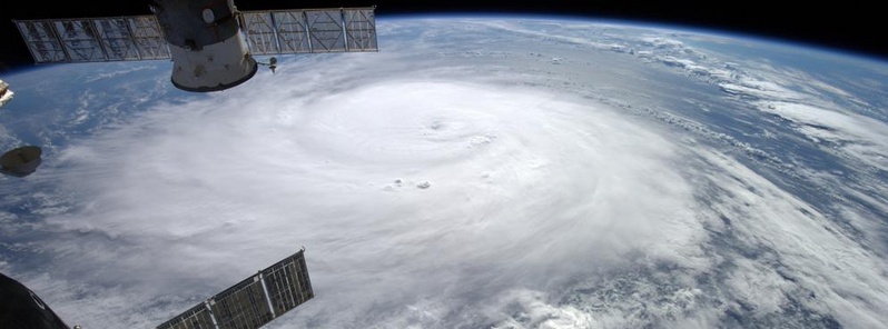
Featured image: Hurricane "Gonzalo" seen from ISS. Credit: NASA / ISS.
Hurricane "Gonzalo" made a full landfall on British island of Bermuda about 23:30 UTC (20:30 local time) on Friday, October 17, as the 56 km wide (35 miles) eye of the storm crossed the south-central coast of the island, the U.S. National Hurricane Center in Miami reported.
Gonzalo was dangerous Category 2 hurricane packing sustained winds of up to 175 km/h (110 mph) when it hit. Most of the electricity throughout the island was knocked down.
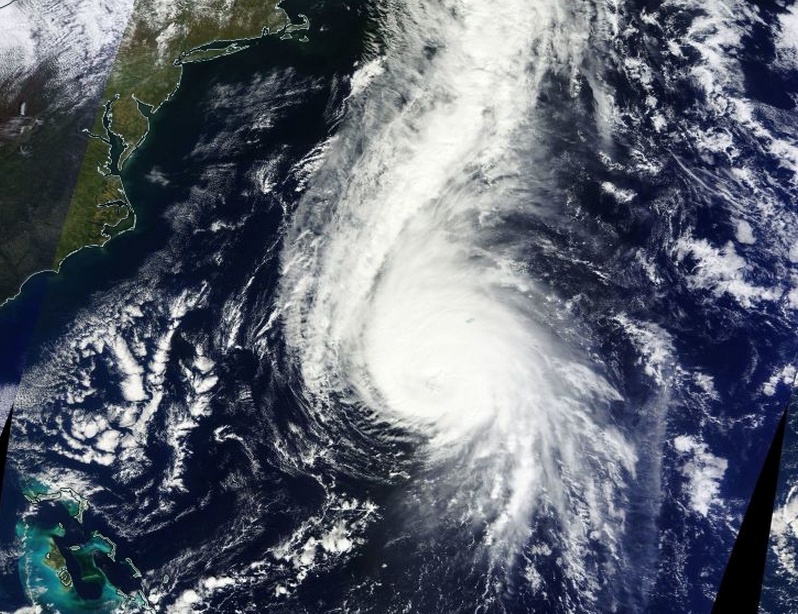
Hurricane "Gonzalo" on October 17, 2014. Image credit: NASA Terra/MODIS.
Bermuda Weather Service said damage to the old and new hospitals has been reported, the AWOS weather sensors at the Bermuda International Airport have been damaged due to saltwater inundation and are inoperable, and the RCC Bermuda Radio Maritime Operations Center at St. Georges has been damaged and is inoperable too.
There were no immediate reports of injuries.
The Royal Gazette said there was flooding and storm surges all around the island. Residents reported a strange calm as the eye of the storm passed, after which the second half of Gonzalo again lashed the island with pounding rains and potentially destructive winds.
"Large areas of the Island’s roads are blocked by fallen trees. Information received at 3.30 am [06:30 UTC] states that Trimingham Road and areas of Harbour Road are among those affected.
Residents are urged to stay indoors when the winds ease to allow the emergency services to clear the debris and reach those in urgent need."
#Hurricane #Gonzalo over the Caribbean Sea pic.twitter.com/4ufDIiAA61
— Alexander Gerst (@Astro_Alex) October 17, 2014
At 06:00 UTC today, the center of Hurricane "Gonzalo" was about 160 km (100 miles) northeast of Bermuda. The system had maximum sustained winds of 165 km/h (105 mph) and was moving NNE at 28 km/h (17 mph). Minimum central pressure was 995 mb.
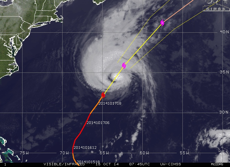
Hurricane "Gonzalo" forecast track by UW-CIMSS. October 18, 2014.
Hurricane force winds extend outward up to 75 km (45 miles) from the center. Tropical storm winds extend outward up to 280 km (175 miles).
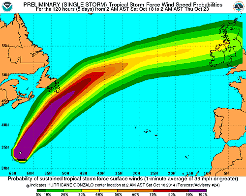
Increasing shear and cooler waters along the track of the hurricane should result in a faster weakening today. Gonzalo is likely to transition into a post-tropical cyclone by 36 to 48 hours as it moves near or south of Newfoundland, NHC said.
FORECAST POSITIONS AND MAX WINDS

INIT  18/0300Z 32.7N  64.5W   95 KT 110 MPH
 12H  18/1200Z 35.9N  62.3W   85 KT 100 MPH
 24H  19/0000Z 41.2N  57.5W   75 KT  85 MPH
 36H  19/1200Z 47.0N  49.7W   65 KT  75 MPH...POST-TROP/EXTRATROP
 48H  20/0000Z 52.0N  39.0W   50 KT  60 MPH...POST-TROP/EXTRATROP
 72H  21/0000Z 57.0N  11.0W   45 KT  50 MPH...POST-TROP/EXTRATROP
 96H  22/0000Z...DISSIPATED
Satellite animations
- Storm-Centered Infrared (GOES 13; NOAA/SSD)
- Storm-Centered Infrared (Aviation Color Enhancement) (GOES 13; NOAA/SSD)
- Storm-Centered Water Vapor (GOES 13; NOAA/SSD)
- Storm-Centered Visible (GOES 13; NOAA/SSD)
- Storm-Centered Visible (Colorized) (GOES 13; NOAA/SSD)
- Storm-Centered Infrared (GOES 13; CIMSS)
- Storm-Centered Enhanced Infrared (GOES 13; CIMSS)
- Storm-Centered Water Vapor (GOES 13; CIMSS)
- Storm-Centered Visible (GOES 13; CIMSS)
- West Atlantic Infrared (GOES 13; NOAA/SSD)
- West Atlantic Infrared (Aviation Color Enhancement) (GOES 13; NOAA/SSD)
- West Atlantic Water Vapor (GOES 13; NOAA/SSD)
- West Atlantic Visible (GOES 13; NOAA/SSD)
- West Atlantic Visible (Colorized) (GOES 13; NOAA/SSD)
I'm a dedicated researcher, journalist, and editor at The Watchers. With over 20 years of experience in the media industry, I specialize in hard science news, focusing on extreme weather, seismic and volcanic activity, space weather, and astronomy, including near-Earth objects and planetary defense strategies. You can reach me at teo /at/ watchers.news.
Commenting rules and guidelines
We value the thoughts and opinions of our readers and welcome healthy discussions on our website. In order to maintain a respectful and positive community, we ask that all commenters follow these rules.