
Bardarbunga volcano aviation color code raised back to Red, Iceland
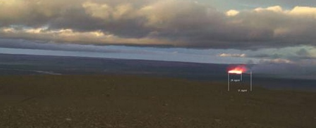
Image credit: Milo webcam
Another fissure eruption has started in Holuhraun, an ice-free area north of the Bárðarbunga volcano, on Sunday, August 31, 2014, at around 05:05 UTC. This is the same place as Friday's eruption but today's eruption is far more powerful.
Icelandic Met Office has again increased aviation color code of the volcano to Red. Intense seismic activity continues around the volcano.
Sveinbjörn Steinþórsson at the Institute of Earth Science at the University of Iceland, says that the eruption is far more powerful than the last one.
"The plumes reach 20 to 30 meters into the air. There are, however, no explosions in the rift… This eruption is a lot bigger, there is volcanic activity in a 1 200 meter long rift. There is one crater in the south of the rift that is not connected to ther other parts of the eruption," Sveinbjörn says. (MBL)
"That one [Fridays eruption] faded away almost instantly. This one is obviously more powerful and shows no signs of fading."
Scientists pointed out out that the lava which entered the surface on Friday was only about a thousandth of the magma on the move under the surface.
Accordint to IMO, at this moment it is unclear how the situation will develop. However, four scenarios are considered most likely:
- The migration of magma could stop, resulting in a gradual reduction in seismic activity and no further eruptions.
- The dike could reach the Earth's surface north of Dyngjujökull causing another eruption, possibly on a new fissure. Such an eruption could include lava flow and (or) explosive activity.
- The intrusion reaches the surface and an eruption occurs again where either the fissure is partly or entirely beneath Dyngjujökull. This would most likely produce a flood in Jökulsá á Fjöllum and perhaps explosive, ash-producing activity.
- An eruption in Bárðarbunga. The eruption could cause an outburst flood and possibly an explosive, ash-producing activity. In the event of a subglacial eruption, it is most likely that flooding would affect Jökulsá á Fjöllum. However it is not possible to exclude the following flood paths: Skjálfandafljót, Kaldakvísl, Skaftá and Grímsvötn.
Pahoehoe lava flow this morning, or what we call "helluhraun". Pic by Ármann Höskuldsson #Bardarbunga #Holuhraun pic.twitter.com/I77O0GfRbK
— Univ. of Iceland (@uni_iceland) August 31, 2014
Beauty! Pic from our geologist Ármann Höskuldsson of today's eruption #Holuhraun #Bardarbunga pic.twitter.com/HjIKatJjpv
— Univ. of Iceland (@uni_iceland) August 31, 2014
Video courtesy of Benedikt G. Ófeigsson
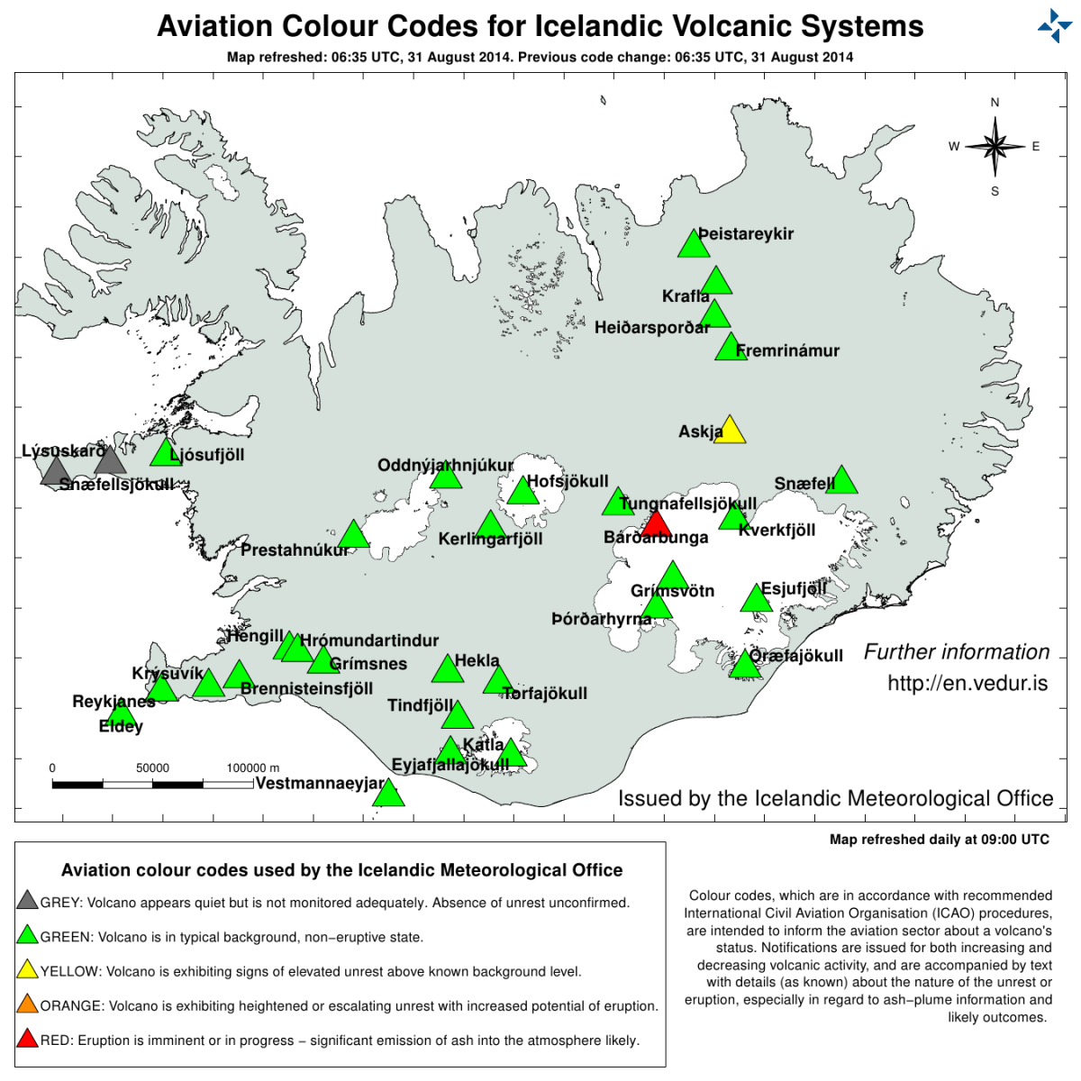
Overall assessment from the joint status report 310814 of the Icelandic Met Office and the University of Iceland, Institute of Earth Sciences (16:41 UTC):
Weather conditions made it difficult to follow the progression of the eruption since this morning, but scientists are in the area, using every opportunity to acquire information on gas and lava outflow. Weather conditions do not allow overflight at this time. The Aviation Colour Code for Bárðarbunga was rised at ‘red' this morning and it has been moved back to 'orange' since 15:00 UTC. The color code for Askja is at ‘yellow'.
Update, 18:21 UTC:
Few additional facts since status report earlier today: Now about 700 earthquakes have been detected since midnight. An earthquake M4.9 occurred at 16:12 on the northern rim of the Bárðarbunga caldera. The main seismic activity has been in the intrusive dike. Only a few quakes have been located near the caldera rim, mostly its nortern part. Little seismic activity has been near Askja but some seismic activity near Herðubreiðartögl. Weather conditions; very windy. (IMO)
Geologic summary
The large central volcano of Bárdarbunga lies beneath the NW part of the Vatnajökull icecap, NW of Grímsvötn volcano, and contains a subglacial 700-m-deep caldera. Related fissure systems include the Veidivötn and Trollagigar fissures, which extend about 100 km SW to near Torfajökull volcano and 50 km NE to near Askja volcano, respectively. Voluminous fissure eruptions, including one at Thjorsarhraun, which produced the largest known Holocene lava flow on Earth with a volume of more than 21 cu km, have occurred throughout the Holocene into historical time from the Veidivötn fissure system.
The last major eruption of Veidivötn, in 1477, also produced a large tephra deposit. The subglacial Loki-Fögrufjöll volcanic system located SW of Bárdarbunga volcano is also part of the Bárdarbunga volcanic system and contains two subglacial ridges extending from the largely subglacial Hamarinn central volcano; the Loki ridge trends to the NE and the Fögrufjöll ridge to the SW. Jökulhlaups (glacier-outburst floods) from eruptions at Bárdarbunga potentially affect drainages in all directions. (GVP)
I'm a dedicated researcher, journalist, and editor at The Watchers. With over 20 years of experience in the media industry, I specialize in hard science news, focusing on extreme weather, seismic and volcanic activity, space weather, and astronomy, including near-Earth objects and planetary defense strategies. You can reach me at teo /at/ watchers.news.
Just when you thought it was safe