
Increased seismicity under Loki-Fögrufjöll volcano (Hamarinn), Iceland
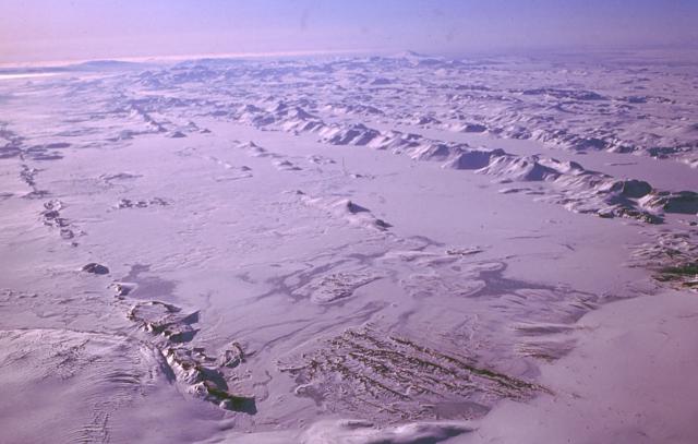
Featured image: The subglacial Loki-Fögrufjöll volcanic system, seen here from the ENE, is located SW of Bárdarbunga volcano and is also part of the Bárdarbunga volcanic system. It contains two subglacial ridges extending from the largely subglacial Hamarinn central volcano; the Loki ridge trends to the NE and the Fögrufjöll ridge, seen here, extends to the SW. Credit: Oddur Sigurdsson, 1994 (Icelandic National Energy Authority).
Increased seismic activity is taking place under Iceland's Hamarinn volcano, a part of Bardarbunga volcanic system, also known as Loki-Fögrufjöll.
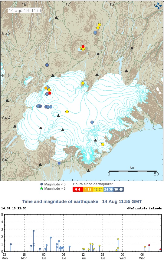
The largest earthquakes over the past 48 hours were two M2.8 registered at a depth of 11 km (6.8 miles) at 20:46 and 20:47 UTC. 6 other earthquakes were registered by IMO during the same period, ranging from M0.5 – 1.4 (depths 0.5 km / 0.3 miles – 11 km / 6.8 miles).
The last time Hamarinn volcano had this type of earthquake activity was in 2011, Jon Frimann reports. Increased seismic activity lasted for several months before a glacial-outburst flood event (jökulhlaup) started on July 13, 2011.
Around 280 earthquakes were located by the IMO from August 5 – 11, 2019, similar to the previous week, when 250 were located. The largest earthquake, a M2.9 occurred at 13:53 UTC on August 11, some 20 km (12.4 miles) NW of Gjögurtá. More earthquakes were detected in North Iceland and Vatnajökull glacier. The intensity increased on the Öræfajökull volcano. Two minor earthquakes where detected in Hekla, all smaller than M1.0.
Geological summary
The large central volcano of Bárðarbunga lies beneath the NW part of the Vatnajökull icecap, NW of Grímsvötn volcano, and contains a subglacial 700-m-deep (2 300 feet) caldera. Related fissure systems include the Veidivötn and Trollagigar fissures, which extend about 100 km (62 miles) SW to near Torfajökull volcano and 50 km (31 miles) NE to near Askja volcano, respectively.
Voluminous fissure eruptions, including one at Thjorsarhraun, which produced the largest known Holocene lava flow on Earth with a volume of more than 21 km3 (5 mi3), have occurred throughout the Holocene into historical time from the Veidivötn fissure system.
The last major eruption of Veidivötn, in 1477, also produced a large tephra deposit. The subglacial Loki-Fögrufjöll volcanic system to the SW is also part of the Bárðarbunga volcanic system and contains two subglacial ridges extending from the largely subglacial Hamarinn central volcano; the Loki ridge trends to the NE and the Fögrufjöll ridge to the SW. Jökulhlaups (glacier-outburst floods) from eruptions at Bárðarbunga potentially affect drainages in all directions. (GVP)
I'm a dedicated researcher, journalist, and editor at The Watchers. With over 20 years of experience in the media industry, I specialize in hard science news, focusing on extreme weather, seismic and volcanic activity, space weather, and astronomy, including near-Earth objects and planetary defense strategies. You can reach me at teo /at/ watchers.news.
Commenting rules and guidelines
We value the thoughts and opinions of our readers and welcome healthy discussions on our website. In order to maintain a respectful and positive community, we ask that all commenters follow these rules.