
M4.1 earthquake hits Bardarbunga volcano, Iceland
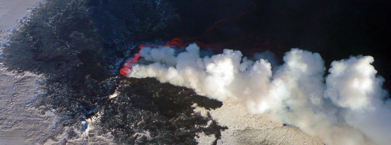
Featured image: Bardarbunga - Holuhraun eruption on October 21, 2014. Credit: Milan Nykodyn
Magnitude 4.1 earthquake was registered in the southern part of the Bardarabunga volcano caldera, Iceland on March 21, 2018. The quake hit at 22:56 UTC at a depth of 4.5 km (2.8 miles).
It was followed M2.6 at 23:02 and 2.5 at 00:38 UTC, March 22 and half a dozen of smaller quakes, but there are no signs of volcanic tremors.
These are the first quakes in the volcano since the end of January when Bardarbunga was hit by the largest quake since the end of the 2014/15 eruption.
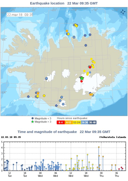
Bardarbunga, one of the most powerful volcanic systems in Iceland, has been showing a significant level of activity in recent months, Iceland Magazine reports. These quakes are caused by magma being thrust from the Earth's mantle up into the lava chambers of the volcano. The volcano has been re-filling it's lava chambers since the end of the 2014-15 Holuhraun eruption.
Geological summary
The large central volcano of Bárðarbunga lies beneath the NW part of the Vatnajökull icecap, NW of Grímsvötn volcano, and contains a subglacial 700-m-deep (2 300 feet) caldera. Related fissure systems include the Veidivötn and Trollagigar fissures, which extend about 100 km SW to near Torfajökull volcano and 50 km (31 miles) NE to near Askja volcano, respectively.
Voluminous fissure eruptions, including one at Thjorsarhraun, which produced the largest known Holocene lava flow on Earth with a volume of more than 21 km3 (5 mi3), have occurred throughout the Holocene into historical time from the Veidivötn fissure system.
The last major eruption of Veidivötn, in 1477, also produced a large tephra deposit. The subglacial Loki-Fögrufjöll volcanic system to the SW is also part of the Bárðarbunga volcanic system and contains two subglacial ridges extending from the largely subglacial Hamarinn central volcano; the Loki ridge trends to the NE and the Fögrufjöll ridge to the SW. Jökulhlaups (glacier-outburst floods) from eruptions at Bárðarbunga potentially affect drainages in all directions. (GVP)
I'm a dedicated researcher, journalist, and editor at The Watchers. With over 20 years of experience in the media industry, I specialize in hard science news, focusing on extreme weather, seismic and volcanic activity, space weather, and astronomy, including near-Earth objects and planetary defense strategies. You can reach me at teo /at/ watchers.news.
Commenting rules and guidelines
We value the thoughts and opinions of our readers and welcome healthy discussions on our website. In order to maintain a respectful and positive community, we ask that all commenters follow these rules.