
Earthquake swarm in the volcanic chain between Momotombo and Apoyeque continues, Nicaragua
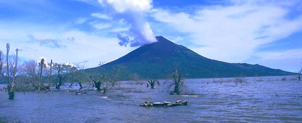
Image credit: Momotombo volcano, Lake Managua - Nicaragua. From www.world-traveller.org
An earthquake measuring M6.6 on the Richter scale hit Nicaragua on April 11, 2014 affecting a total of 2 403 homes of which 178 collapsed, were totally destroyed or rendered uninhabitable. The remaining 2 225 homes suffered partial damage.
The earthquake originated in Lake Managua, 15 km NE from Momotombo volcano, and was followed by numerous aftershocks in the area east of the volcano, as well as near Apoyeque volcano on the peninsula in Lake Managua to the SE.
Within the first five days there were 400 seismic events nationwide, with a frequency of 41 to 96 per day.
More than 12 000 people were affected and are in need of assistance. Water and electrical services have been interrupted, Food for the Hungry reported yesterday.
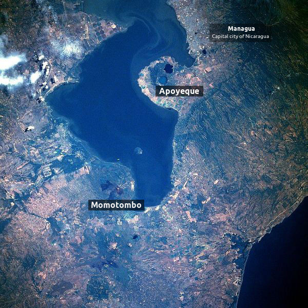
Lake Managua (also known as Lake Xolotlán), and its surrounding area, is a home to numerous volcanoes and volcano craters. It is the second largest freshwater lake in Central America.
The city of Managua, nations capital, is located on its SW shore and has been prone to many destructive earthquakes during its history, the last one occurring December 23, 1972 when Managua was almost completely destroyed and more than 10 000 lives were lost.
Lake Manaqua, Nicaragua. Image author: NASA astronaut during Space Shuttle mission (STS61C) – January 1986. Edit: The Watchers

Perspective view with Landsat Overlay, Lakes Managua (foreground) and Nicaragua (background). Image credit: NASA / JPL
Nicaragua has 19 active volcanoes which form a NW-SE running chain mostly inside the Nicaraguan Depression graben.
Most noticeable active volcano near Managua Lake, is a young, 1297 meters high, Momotombo stratovolcano rising above its NW shore. Momotombo has a long record of strombolian eruptions, punctuated by occasional larger explosive activity. The latest eruption, in 1905, produced a lava flow that traveled from the summit to the lower NE base. A small black plume was seen above the crater after an April 10, 1996 earthquake, but later observations noted no significant changes in the crater.
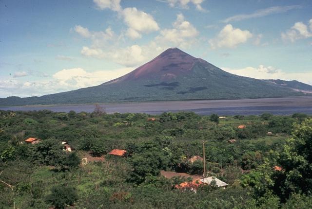
Momotombo volcano, Nicaragua. Image credit: GVP
.jpg)
This image was acquired on January 21, 2014, and is provided by the ISS Crew Earth Observations experiment and Image Science & Analysis Laboratory, Johnson Space Center.
The Apoyeque volcanic complex occupies the broad Chiltepe Peninsula, which extends into south-central Lake Managua. The peninsula is part of the Chiltepe pyroclastic shield volcano, one of three large ignimbrite shields on the Nicaraguan volcanic front. A 2.8-km wide, 400-m-deep, lake-filled caldera whose floor lies near sea level truncates the low Apoyeque volcano, which rises only about 500 m above the lake shore. Last know eruption of this volcano occured in 50 BCE, it had Volcanic Explosivity Index of 6.
A swarm of small earthquakes was detected near Apoyeque in 2012. These seismic swarms, when detected in volcanically active areas, can indicate movement of magma prior to an eruption. The capital city of Managua, not visible in the image, is located approximately 15 kilometers (9 miles) to the SE of Apoyeque, while the town of Bosques de Xiloa is considerably closer (approximately 4 kilometers, or 2.5 miles). (EO)

Earthquakes M3+ between Momotombo and Apoyeque (volcanoes during April 12 and 13, 2014. Image courtesy of Volcano Discovery.
Two days after M6.6 earthquake on April 11, 2014, Volcano Discovery reported that seismicity in the volcanic chain between Momotombo and Apoyeque volcanoes remains high. Dozens of shallow earthquakes in the magnitude 3-5 range have been occurring daily in a cluster SE of Momotombo and near Apoyeque.
"The quakes are probably tectonic in origin, and INETER has not reported any unusual activity at the volcanoes. On the other hand, earthquakes of this size could disturb the plumbing system of the volcanoes and potentially help trigger new activity."
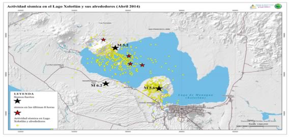
Lake Managua earthquake swarm – April 30, 2014. Image credit: INETER – Instituto Nicaragüense de Estudios Territoriales
This phase of increased seismicity that started on April 10 with M6.1 earthquake is ongoing.
Click here for INETER's list of most recent earthquakes in Nicaragua.
I'm a dedicated researcher, journalist, and editor at The Watchers. With over 20 years of experience in the media industry, I specialize in hard science news, focusing on extreme weather, seismic and volcanic activity, space weather, and astronomy, including near-Earth objects and planetary defense strategies. You can reach me at teo /at/ watchers.news.
lets get ready to rumble