
Strong and shallow earthquake M6.2 struck Guerrero, Mexico
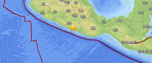
Image credit: USGS/Leaflet
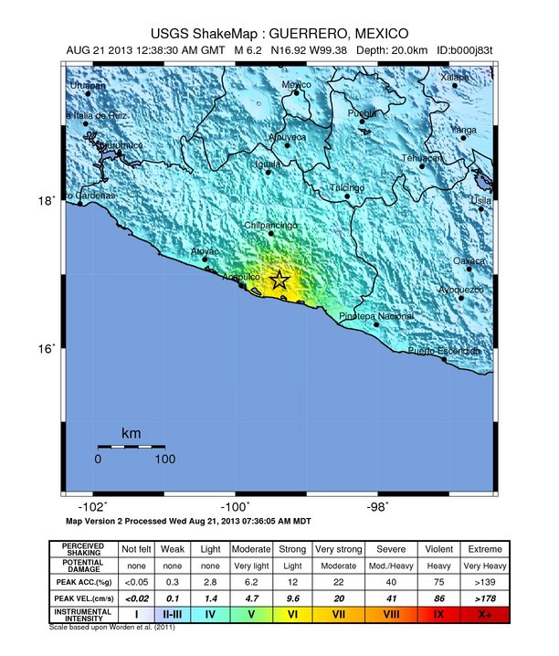
A strong and shallow earthquake with recorded magnitude of 6.2 (USGS) struck Guerrero, Mexico on August 21, 2013 at 12:38 UTC. USGS measured depth at 20 km (12.4 miles), EMSC reports magnitude 6.2 earthquake at depth of 30 km.
Epicenter was located on land, 18 km (11 miles) NW of Ayutla de los Libres, 59 km (37 miles) ENE of Acapulco de Juarez and 268 km (167 miles) S of Mexico city, Mexico.
There are 1 931 554 people living within 100 km radius.
An EMSC reader located 251 km N of epicenter said:
The whole house shuck, and the roads looks like they where doing "the worm" a flow kind of thing.
The data is still preliminary. This page will be updated.
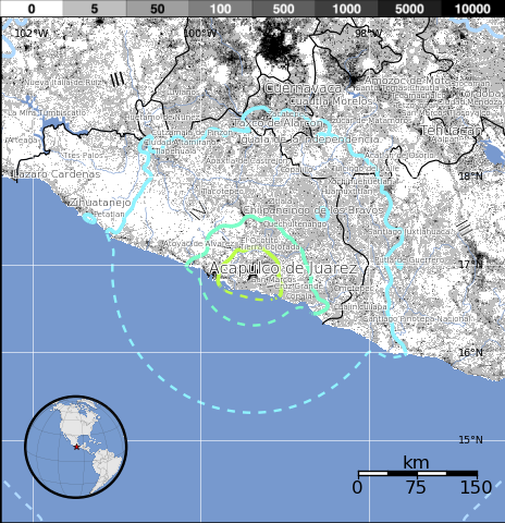
Population exposure
Population per ˜1 sq. km. from LandScan
Structure information summary
Overall, the population in this region resides in structures that are a mix of vulnerable and earthquake resistant construction. The predominant vulnerable building types are mud wall and unreinforced brick masonry construction.
Secondary effects
Recent earthquakes in this area have caused secondary hazards such as landslides that might have contributed to losses.
Selected cities exposed
from GeoNames Database of Cities with 1,000 or more residents.
| MMI | City | Population |
|---|---|---|
| VI | San Marcos | 12k |
| VI | Ayutla de los Libres | 10k |
| VI | Cruz Grande | 10k |
| VI | El Ocotito | 6k |
| VI | Tierra Colorada | 10k |
| VI | Copala | 7k |
| IV | Mexico City | 12,294k |
| III | Puebla de Zaragoza | 1,590k |
| III | Toluca | 506k |
| III | Morelia | 593k |
| III | Xalapa de Enriquez | 425k |
(k = x1,000)
Seismotectonics of Mexico
Located atop three of the large tectonic plates, Mexico is one of the world's most seismologically active regions. The relative motion of these crustal plates causes frequent earthquakes and occasional volcanic eruptions. Most of the Mexican landmass is on the westward moving North American plate. The Pacific Ocean floor south of Mexico is being carried northeastward by the underlying Cocos plate. Because oceanic crust is relatively dense, when the Pacific Ocean floor encounters the lighter continental crust of the Mexican landmass, the ocean floor is subducted beneath the North American plate creating the deep Middle American trench along Mexico's southern coast. Also as a result of this convergence, the westward moving Mexico landmass is slowed and crumpled creating the mountain ranges of southern Mexico and earthquakes near Mexico's southern coast. As the oceanic crust is pulled downward, it melts; the molten material is then forced upward through weaknesses in the overlying continental crust. This process has created a region of volcanoes across south-central Mexico known as the Cordillera Neovolcánica.
The area west of the Gulf of California, including Mexico's Baja California Peninsula, is moving northwestward with the Pacific plate at about 50 mm per year. Here, the Pacific and North American plates grind past each other creating strike-slip faulting, the southern extension of California's San Andreas fault. In the past, this relative plate motion pulled Baja California away from the coast forming the Gulf of California and is the cause of earthquakes in the Gulf of California region today.
Mexico has a long history of destructive earthquakes and volcanic eruptions. In September 1985, a magnitude 8.1 earthquake killed more than 9,500 people in Mexico City. In southern Mexico, Volcán de Colima and El Chichón erupted in 2005 and 1982, respectively. Paricutín volcano, west of Mexico City, began venting smoke in a cornfield in 1943; a decade later this new volcano had grown to a height of 424 meters. Popocatépetl and Ixtaccíhuatl volcanos ("smoking mountain" and "white lady", respectively), southeast of Mexico City, occasionally vent gas that can be clearly seen from the City, a reminder that volcanic activity is ongoing. In 1994 and 2000 Popocatépetl renewed its activity forcing the evacuation of nearby towns, causing seismologists and government officials to be concerned about the effect a large-scale eruption might have on the heavily populated region. Popocatépetl volcano last erupted in 2010. More information on regional seismicity and tectonics
I'm a dedicated researcher, journalist, and editor at The Watchers. With over 20 years of experience in the media industry, I specialize in hard science news, focusing on extreme weather, seismic and volcanic activity, space weather, and astronomy, including near-Earth objects and planetary defense strategies. You can reach me at teo /at/ watchers.news.
Commenting rules and guidelines
We value the thoughts and opinions of our readers and welcome healthy discussions on our website. In order to maintain a respectful and positive community, we ask that all commenters follow these rules.