
Red alert issued as Super Typhoon Utor made landfall in Philippines

Image credit: TW
Residents of the Philippines are on high alert as Super Typhoon Utor made a landfall near the Casapsapan Bay, over Isabela-Aurora. Utor's maximum sustained winds reached 130 knots (150mph/241 km/h) at 15:00 UTC on August 11, 2013 and the system was upgraded to a super typhoon. Utor had undergone some weakening and lost its super typhoon status prior to landfall.
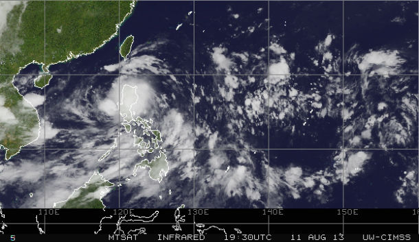
MTSAT Infrared satellite image taken at 19:30 UTC on August 11, 2013 (Credit: NOAA/MTSAT/CIMSS)
Utor (Labuyo) is the strongest typhoon to hit the Philippines so far this year. National Disaster Risk Reduction and Management Council (NDRRMC) declared red alert. GDACS estimated population affected by Category 1 typhoon (120 km/h) wind speeds or higher is about 16.7million. Authorities suspended inter-island ferry services and warned people to brace for possible flash floods and landslides.
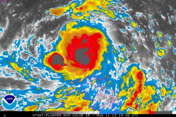
MTSAT Infrared AVN satellite image taken at 19:32 UTC on August 11, 2013 (Credit: NOAA/MTSAT)
Warnings
The 12th tropical cyclone to enter the country this year and the second tropical disturbance this month, will pass Quirino, Nueva Viscaya, Benguet, Ifugao, Mt. Province, La Union, between Ilocos Sur and Ilocos Norte and exit towards the West Philippine Sea. It will take about 12 hours for Utor to cross Luzon.
PAGASA released warnings as Super Typhoon Utor approaching Philippines from the east. Public storm warning signal #1 is in effect in the following provinces: Albay, Sorsogon, Rest of Quezon, Laguna, Calayan, Babuyan Group of Islands, Ilocos Norte, Zambales, Bataan, Cavite, Batangas and Metro Manila.
Public storm warning signal #2 is in effect in the following provinces: Catanduanes, Camarines Norte & Sur, Rizal, Northern Quezon, Bulacan, Pampanga, Tarlac, Pangasinan, La Union, Ilocos Sur, Abra, Apayao, Kalinga and Cagayan.
Public storm warning signal #3 is in effect in the provinces of Aurora, Nueva Viscaya, Mt. Province, Polilio Island, Quirino, Benguet, Ifugao, Nueva Ecija and Isabela. Once storm signal #3 is raised, classes in all levels, including college, are suspended.
Officials warned residents in low-lying and mountainous areas against possible flashfloods and landslides while those under storm warning signals No. 2 and 3 were alerted against possible storm surges. 390,000 people are living in coastal areas below 5 meters and can therefore be affected by storm surge. The typhoon is also generating waves between 9 and 12 meters (30 and 40 feet) over the waters east of Luzon.
More than 50 fishermen have been reported missing and more than 7,500 people were stranded in ports as passenger and cargo ferry services were canceled due to rough seas.
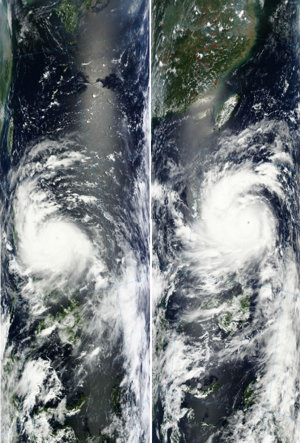
MODIS satellite imagery from August 11, 2013 (Credit: LANCE Rapid Response/MODIS)
According to latest report by Joint Typhoon Warning Center (JTWC), the center of Typhoon Utor was located approximately 109 nm northeastward of Manila, Philippines, The system is moving west-northwestward at speed of 15 knots. Maximum sustained winds are 120 knots with gusts up to 145 knots.
Rainfall
NASA's TRMM satellite captured rates of heavy rainfall around the storm's center and western quadrant. Utor's rainfall had already start spreading over the northern and central Phillippines. Utor is predicted to dump 150 to 250 mm (6 to 12 inches) of rain (heavy to intense) within its 600-km radius.

NASA's Tropical Rainfall Measuring Mission or TRMM satellite passed over Utor on August 11, 2013 at 07:19 UTC and captured rainfall rates near 1.4 inches per hour around the storm's center and western quadrant as it nears landfall. (Credit: NASA TRMM/METSAT/NRL)
Forecast
Utor has accelerated and weakened slightly as the northwestern periphery of the system began to interact with Luzon island, causing a disruption of the surface circulation. After weakening over the Philippines, Utor is expected to re-strengthen in the South China Sea before making landfall in southern China. These areas were hit hard by Mangkhut and Jebi.
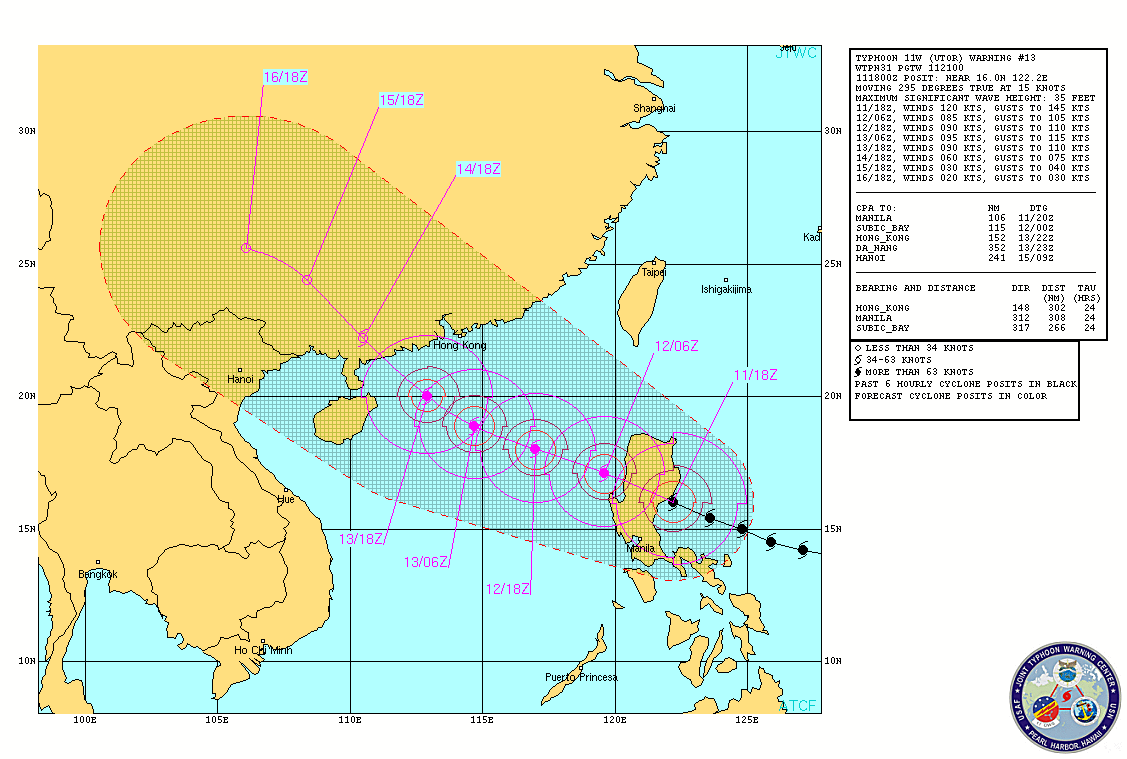
Typhoon Utor forecast track (Credit: JTWC)
The system will weaken considerably over the next 12 hours as it tracks over the terrain of Luzon, before emerging into the South China Sea. Favorable environmental conditions will allow steady intensification after the next 36 hours. The cyclone is expected to make landfall west-southwest of Hong Kong, and begin a rapid dissipation.
Satellite Animations
- Storm-Centered Infrared (MTSAT; NOAA/SSD)
- Storm-Centered Infrared (Aviation Color Enhancement) (MTSAT; NOAA/SSD)
- Storm-Centered Water Vapor (MTSAT; NOAA/SSD)
- Storm-Centered Visible (MTSAT; NOAA/SSD)
- Storm-Centered Visible (Colorized) (MTSAT; NOAA/SSD)
- West Pacific/South China Sea Infrared (MTSAT2; NOAA)
- West Pacific/South China Sea Enhanced Infrared (MTSAT2; NOAA)
- West Pacific/South China Sea Water Vapor (MTSAT2; NOAA)
Commenting rules and guidelines
We value the thoughts and opinions of our readers and welcome healthy discussions on our website. In order to maintain a respectful and positive community, we ask that all commenters follow these rules.