
Dalila weakens into tropical storm again
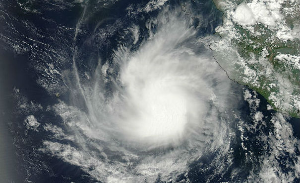
Featured image: Aqua MODIS satellite captured an image of Dalila reaching hurricane status on July 2, 2013 after Dalila became a hurricane. (Credit: NASA GSFC/MODIS Rapid Response Team)
Dalila reached hurricane status on July 2, 2013 but quickly weakened into tropical storm again. Although the storm is well off the southwest coast of Mexico and moving away from land it will continue to produce large surf and swells along portions of the central west coast of Mexico, resulting in dangerous surf conditions and rip currents.
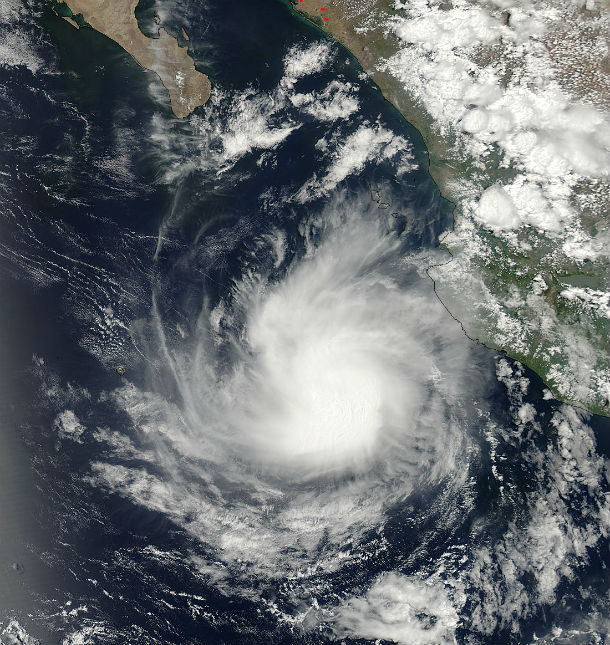
Aqua MODIS satellite image of Eastern Pacific on July 2, 2013 after Dalila became a hurricane. Dalila had strong thunderstorms around its center and bands of thunderstorms in the northern and southern quadrants. (Credit: NASA GSFC/MODIS Rapid Response Team)
According to latest public advisory issued by US National Hurricane Center (NHC) at 03:00 UTC on July 4, 2013, the center of Tropical Storm Dalila was located about 285 miles (460 km) WSW of Manzanillo, Mexico, at coordinates 17.6N and 108.4W. The system is moving westward at speed of 5 mph (7 km/h) and this general motion is expected to continue for the next 2 to 3 days. Minimum central pressure is 995 mb (29.38 inches).
Maximum sustained winds have decreased to near 60 mph (95 km/h). Tropical storm force winds extend outward up to 60 miles (95 km) from the center.
.png)
TS Dalila 5-day tropical wind speed probabilities map (Credit: NOAA/NHC)
The most recent satellite imagery reveals that the cloud pattern of Dalila is deteriorating fast. The low-level center is removed from a shrinking area of deep convection. It appears that dry and stable air is already affecting the circulation. The official forecast calls for a gradual weakening, but this process could occur faster than forecast.
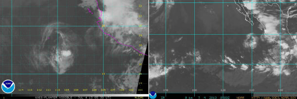
GOES-15 infrared satellite image of storm center on July 4, 2013 at 05:30 UTC and East Pacific hurricane sector visible image taken on July 4, 3023 at 05:00 UTC (Credit: NOAA/GOES West)
Dalila has barely moved during the day, trapped to the south of a strong mid-level ridge. This pattern should keep the cyclone on a slow west-southwestward to westward track during the next few days until dissipation. This scenario is consistent with most of the track model guidance.
.png)
Dalila forecast track by NHC, JTWC and UWM (Credit: NOAA/NHC/JTWC/UWM)
Another area of low pressure is getting better organized south of the southern coast of Mexico. Conditions are favorable for development of this feature. NOAA/NHC forecast 70% chances of developing into a tropical system within the next day or so. It is expected to move west or west-northwest.
.png)
Eastern Pacific tropical weather outllok for July 4, 2013 (Credit: NOAA/NHC)
Satellite Animations
- Storm-Centered Infrared (GOES 15; NOAA/SSD)
- Storm-Centered Infrared (Aviation Color Enhancement) (GOES 15; NOAA/SSD)
- Storm-Centered Water Vapor (GOES 15; NOAA/SSD)
- Storm-Centered Visible (GOES 15; NOAA/SSD)
- Storm-Centered Visible (Colorized) (GOES 15; NOAA/SSD)
- Tropical East Pacific Hurricane Sector Infrared (GOES 15; NOAA)
- Tropical East Pacific Hurricane Sector Water Vapor (GOES 15; NOAA)
- Tropical East Pacific Hurricane Sector Visible (GOES 15; NOAA)
Commenting rules and guidelines
We value the thoughts and opinions of our readers and welcome healthy discussions on our website. In order to maintain a respectful and positive community, we ask that all commenters follow these rules.