
Tropical Storm Dalila close to southern Mexican coast
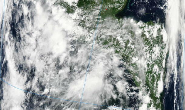
Featured image: MODIS satellite image captured by Aqua at 19:25 UTC on June 30, 2013 (Credit: LANCE/MODIS Rapid Responce)
System 96E in Eastern Pacific became a tropical depression late on June 29, 2013 and quickly grew into Tropical Storm Dalila early on June 30, 2013.
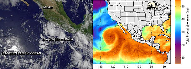
GOES Infrared satellite image and MIMIC Total precipitable water on June 30, 2013 (Credit: GOES/MIMIC-TPW/CIMSS)
According to latest public advisory issued by US National Hurricane Center (NHC) at 21:00 UTC on June 30, 2013, the center of TS Dalila was located near 16.2, -103.7, about 195 miles (320 km) SSE of Manzanillo, Mexico with movement NNW at 9 mph (15 km/h). Tropical-storm-force winds extend outward up to 35 miles (55 km) from the center. The minimum central pressure was 1003 mb (29.62 inches) with maximum sustained winds of about 40 mph (65 km/h). Some strengthening is forecast during the next 48 hours.
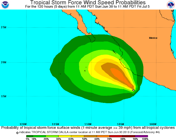
Tropical storm wind speed probabilities 5-day forecast forecast for period from June 30 to July 5, 2013 (Credit: NOAA/NHC)
Dalila is moving north-northwestward and a gradual turn toward the northwest is expected during the next 24 hours, followed by a turn toward the west-northwest at a slower forward speed. The center is expected to pass close to the southwestern coast of Mexico, from Punta San Telmo to la Fortuna on July 1, 2013.
NHC's Discussion report indicates that although situated in an environment that seems conducive to intensification, Dalila has not strengthened over the past several hours. The cloud pattern has become less organized since early June 30, 2013. The cyclone is of marginal tropical storm strength so the current wind speed estimate is held at 35 kt. Since conditions should favor strengthening over the next couple of days, the official forecast continues to show winds approaching hurricane force in about 48 hours. The official wind speed forecast is a blend of the statistical-dynamical and regional hurricane model guidance.
.png)
TS Dalila forecast tracks by NOAA/NHC, JTWC and UWM Spaghetti (Credit: NOAA/NHC/JTWC/UWM)
The center has been very difficult to locate on geostationary imagery, even with high-resolution visible images. A mid-tropospheric ridge associated with a high pressure center over the southwestern U.S. should cause the tropical cyclone to turn northwestward ot west-northwestward, and eventually westward during the forecast period.
.jpg)
GOES West and GOES East composite infrared satellite image taken on June 30, 2013 at 21:30 UTC (Credit: GOES/UW/CIMSS)
A Tropical Storm Warning is in effect for the southwest coast of Mexico, meaning that tropical storm conditions are expected somewhere within the warning area within 36 hours.
A Tropical storm watch is in effect for the southwest coast of Mexico from north of la Fortuna to Cabo Corrientes, which means that tropical storm conditions are possible within the watch area, generally within 48 hours.
Tropical storm conditions are expected to reach the coast within the warning area early on July 1, 2013, and tropical storm conditions are possible in the watch area by the end of the day.
Dalila is expected to produce total rain accumulations of 1 to 3 inches over coastal portions of the Mexican states of Michoacan, Colima and Jalisco. The likely impacts will be enhanced showers and thunderstorms, along with rough surf and the possibility of tropical storm force gusts.
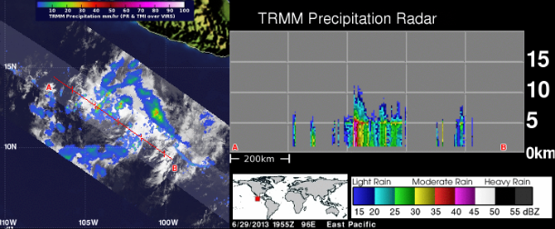
Tropical Rainfall Measuring Mission (TRMM) Precipitation Radar shows confditions on East Pacific on June 29, 2013 at 19:55 UTC (Credit: NASA/TRMM/GSFC)
Satellite Animations
- Storm-Centered Infrared (GOES 15; NOAA/SSD)
- Storm-Centered Infrared (Aviation Color Enhancement) (GOES 15; NOAA/SSD)
- Storm-Centered Water Vapor (GOES 15; NOAA/SSD)
- Storm-Centered Visible (GOES 15; NOAA/SSD)
- Storm-Centered Visible (Colorized) (GOES 15; NOAA/SSD)
- Tropical East Pacific Hurricane Sector Infrared (GOES 15; NOAA)
- Tropical East Pacific Hurricane Sector Water Vapor (GOES 15; NOAA)
- Tropical East Pacific Hurricane Sector Visible (GOES 15; NOAA)
Commenting rules and guidelines
We value the thoughts and opinions of our readers and welcome healthy discussions on our website. In order to maintain a respectful and positive community, we ask that all commenters follow these rules.